

Heading east from Dewey, this is the 7th segment of General Crook Trail.
I originally plotted the seventh segment of the General Crook Trail to run from General Springs Cabin (V43) to FR 295E (V53). It would have been the same distance and accumulated elevation gain (AEG) as the fourth segment from Upper Sawlog Tank #1 to FR 9361K, but I have not been as active the last few weeks as I should be, so I scaled it back a couple of miles. Good thing I did. 😉
Instead, this segment ends at FR 137 (V51). Originally, in the 1870s, the General Crook Trail’s mileage was scratched in trees and rocks. In the 1970s, the Boy Scouts replaced the missing rocks and fallen trees with a 24″ high logs, 4″ diameter, with the mileage etched into the angled top, and painted white. Many of which are now also missing.
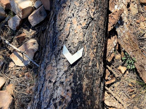
Besides the mile markers, the General Crook Trail is primarily indicated by chevrons. Every topo map claims a different route, and Bowman’s “A Guide to the General Crook Trail” (1978) yet another, but I’ve found chevrons to be the truest indicator. Where chevrons are not available, look for cairns, cut logs and ribbons.
I started hiking a 9:00 a.m., following The_Eagle‘s route from General Springs Cabin, past the spring itself. I didn’t see a single trail marker in over a mile. No sooner had I recorded a note to that affect, than right in front of me I saw a chevron. Turning the opposite direction, I saw a second chevron, and a path past that. I had bumped into the proper route. 👍
I followed the path past the second chevron, ¾ of a chevron-following mile downhill, to just above the Battle of Big Dry Wash memorial. Proper General Crook Trail route established, I turned around and headed back to where I picked it up. (The GPS file attached below contains the correct route.)
If I hadn’t scaled back my hike, I might not have finished until dark. Thankfully, once I picked up the General Crook Trail, it was fairly obvious. At times, it even looked groomed, like by a Mini Cat or compacting machine. A moderately skilled mountain biker could ride much of this segment. 🚴🏻♂️
Depending on how you count, the General Crook Trail crosses Rim Rd. about a dozen times. Plus Coconino National Forest roads FR 95, FR 139, FR 145, FR 321 and multiple dirt roads with even longer numbers. (Rougher, and often decommissioned.) In other words, this segment is not at all remote. You can customize its length to your interest and ability, with out & backs, shuttle hikes or bail points. Make arrangements ahead of time, as cell reception is almost non-existant, even on Rim Rd.
I found General Crook Trail mile marker V45 just before crossing Rim Rd., 1¾ miles from General Springs Cabin. It was 100 yds. before where previous information indicated. At 2¼ miles, The_Eagle’s route diverted left on FR 300F. After some consideration, I continued on the trail.
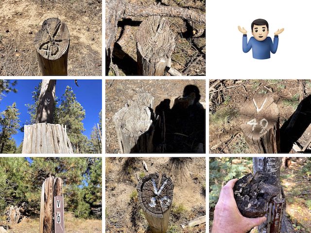
Top Row: V45, V46 barely visible, couldn’t find V47.
Middle Row: V48 pointer chevrons, V48 illegible, V49.
Bottom Row: V50 carsonite post, V50 top, V51 metal u-post?
I lost General Crook Trail at the first Dude Creek observation point. I continued on Rim Rd. for ¼ mile around upper Bear Canyon*, until I picked up the trail at another crossing. Again, I doubled back to establish the correct route. Mile marker V46 was just past that crossing, approaching dry Dude Lake.
I bumped into my wife, driving along Rim Rd., at the Dry Dude Creek observation point. Without her shuttle driving, I wouldn’t be able to do these hikes. At the OP, an orange ribbon marks the General Crook Trail’s route over a steep little hill. After crossing FR 139, the Boy Scout route follows what may be original trail along the top of Barbershop Canyon. 💈
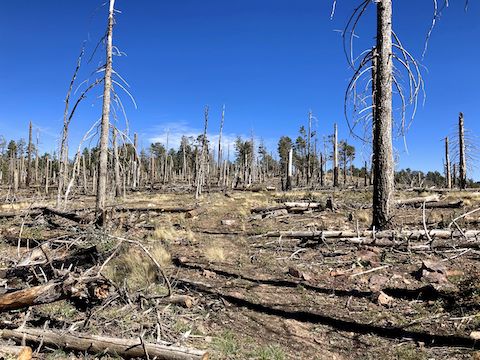
I found mile marker V48 five miles into this General Crook Trail segment, just before the Bonita Creek / Burnt Point OP. The latter appropriately named, as the Dude Fire crested the Mogollon Rim above Perley Creek. The trail through the moonscape was obvious.
General Crook Trail mile marker V49 is 200 yds. east of FR 145. When you cross a road, pay attention to where the trail resumes on the far side: I built at least three small cairns to help, including on FR 321 at 6¾ miles. Which, I should mention, was my tenth mile, due to all my backtracking. (My hike stats typically exceed the route by ~25%). 😅
The General Crook Trail disappeared on the east side of FR 321. There were no chevrons either. I followed the occasional orange ribbon, which indicated what I believed to be the Boy Scout route. Just before mile marker V50, I found a chevron, and just past V50 picked up the trail, which is on decommissioned FR 9714A. At 7¾ miles, the trail splits right to cross Rim Rd.
General Crook Trail is only briefly on the south side of Rim Rd., as it passes through the Dude Fire burn area above Ellison Creek. (Which was the windiest canyon OP yet!) The final 300 yds. of this segment, to FR 137, are on Rim Rd. Mile marker V51 is somewhere just a few yards northwest of that intersection. Search as I might, I couldn’t find it — unless it was that piece of moldy log?
So far, this has been my favorite General Crook Trail hike!
General Springs Directions: From Phoenix, head north on AZ-87, the Beeline Highway, through Payson, Pine and Strawberry. (Alternately, take I-17 north, then AZ-260 east.) 2.6 miles north of AZ-260, turn right onto Rim Rd. / FR 300. Drive 12 miles to the Battle of Big Dry Wash monument. Either park there or, if you have an SUV, turn left down rocky FR 705 for ¼ mile to General Springs Cabin.
FR 137 Directions: Continue east on Rim Rd. / FR 300. In another 8.2 miles, park at the intersection of Rim Rd. and FR 137. Alternately, turn left on FR 137, then park 200 yds. up on the left, next to the fire rings.
GPS File: General_Crook_Trail_V43_V51
Distance: 12.06 mi.
AEG: 1,558 ft.
Time: 4h 57m
Hike Video
Hiking General Crook Trail: V43-V51 from Preston McMurry on Vimeo.