

Heading east from Dewey, this is the 3rd segment of General Crook Trail.
From the Copper Canyon Trailhead (P2) on FR 136, I skipped eight miles past the sidewalk portions of the General Crook Trail in Camp Verde to Clear Creek Campground (V6). If I wanted to hike sidewalks I’d take a spin around my hood in Sunnyslope. I’ve driven those eight “missing” Camp Verde miles more times than I can count, so I consider that segment complete.
P markers represent miles west of Camp Verde; V markers represent miles east of Camp Verde. That system dates back to 1871, when General George Crook surveyed a supply road west from Fort Apache, Arizona, across the Mogollon Rim to Camp Verde, then on to Fort Whipple in Prescott. 🫡
The climb from Clear Creek Campground to Sawlog Tank #2 (V16) is the most elevation gain on the General Crook Trail: 3,000 ft. in ten miles. After a flat first mile, the slope is pretty consistent, varying from 250-400 ft./mile. Not a lot, but steady. Enough overall, I split the segment over two weeks.
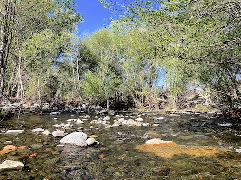
Part 1, to FR 9243C: I started hiking at the Clear Creek Campground entrance on AZ-260 at 9:00 a.m. I followed canopied FR 626 southeast through the campground for ¾ mile. FR 626 ends at a horse lot with a pit toilet. General Crook Trail continues east as foot trail. I had a moment of confusion with the web of trails in the West Clear Creek basin. There were no chevrons, gabions or cairns.
At 1⅓ miles, I found a knee-deep way across running West Clear Creek, picking up my first Boy Scout-installed cairn atop the 10 ft. bank. General Crook Trail cairns follow the old wagon road up a bluff, onto Wingfield Mesa. Unpainted mileage post V7 was just 100 ft. from AZ-260. 🚛
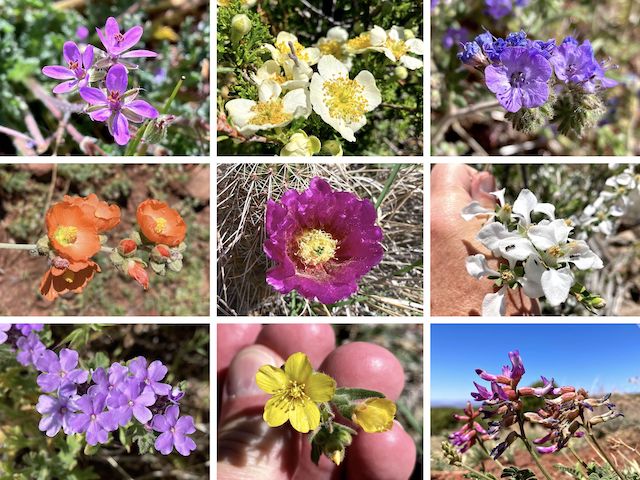
On the day, I spotted at least a dozen flower species: Besides those pictured below, I found desert globemallow, owl clover, suncup, strawberry hedgehog, and some stunning desert paintbrush that I had to low crawl a fence to get a closeup of. (Watch the video below to appreciate that one!)
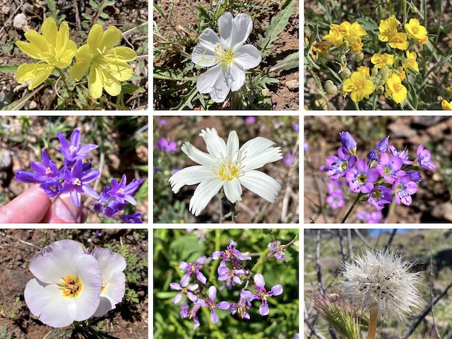
Top Row: desert evening primrose, tufted evening primose, Gordon’s bladderpod.
Middle Row: blue dick, desert chicory, lesser yellowthroat gilia.
Bottom Row: winding mariposa lily, blue mustard, Lindley’s false silverpuff.
After reaching AZ-260, General Crook Trail follows the north side of the AZ-260 right-of-way fenceline, east for the next two miles, to mileage post V9. (Oddly painted on its side, rather than its top.) Sometimes obviously singletrack, sometimes old graded road bed, the trail is never more than 250 ft. from the highway. If in doubt, stay closer to the fence. I was trying to follow the chevrons and cairns.
Just past the 3-mile mark, the old road bed crosses a cattle grate to AZ-260. Instead, split left through the wire loop gate to stay on General Crook Trail. The canyon to your left (north) is Black Mountain Canyon. I saw a number of salt licks along the way, but no cattle tanks. Or any sign of cattle at all. Only critter I remember seeing was a horny toad. 🐸
I may have wandered off course a bit past mileage post V9, where General Crook Trail is as much as 250 yds. from AZ-260, out of sight, on the north side of the spur it’s been ascending. At least part of the time, I was on another wagon road. Maybe not the Boy Scout route, but perhaps the original trail? In any case, at 5½ miles I arrived at FR 9243C, completing my day, having barely noticed the elevation gain.
Statistics: 5.96 mi., 1,517 ft. AEG, 2h 35m.
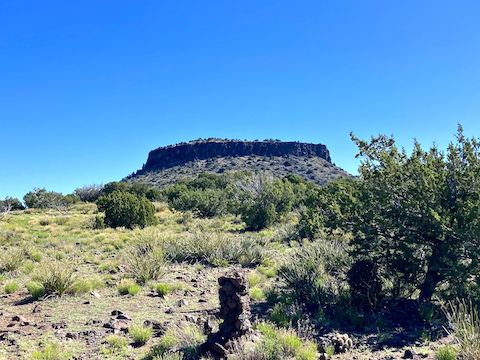
Part 2, to Sawlog Tank #2: I picked up where I left off last week. I started hiking from FR 9243C, near milepost 233 on AZ-260, at 8:20 a.m. It was again a sunny, cloudless, day. General Crook Trail starts off following FR 9243C, but splits right onto singletrack after 100 yds. Initially, I missed the turn. The trail continues to follow the AZ-260 fenceline towards Thirteenmile Rock Butte. 🧭
If you look on satellite view, you can see old road bed paralleling and crisscrossing the highway. I continued following the gabions, chevrons and cairns. One cairn had a broken, unpainted, wood post — which may have been V12, as it was about three miles from V9, and cairns are otherwise not posted. The wiring on the fence changed from single barbed strands, to a medium aperture small gauge mesh.
I briefly had to divert around an old school Class C winnebago parked on FR 9243B. No dog, but I just assume all such vehicles are meth cookers, or otherwise best avoided. The General Crook Trail climbs 100 ft. towards the butte, then dips towards AZ-260. At the lowpoint, there is some slight fence collapse. I crossed there, towards the large pullout, squeezing between the top barbed strand and the mesh.
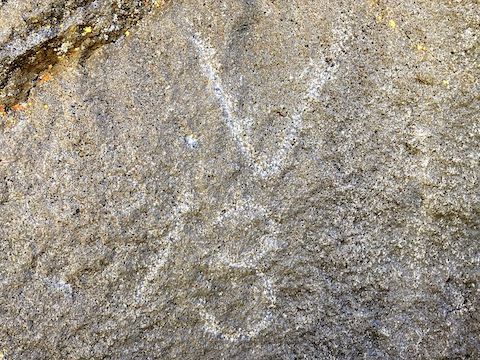
The V13 mileage marker is on a large boulder 75 ft. east of the paved pullout. There is also a brass historical marker. As I was checking it out, my shuttle driving wife drove up. Since she only enjoys my adventures via video, V13 was an easy one to show her in person. Afterwards, I climbed back through the fence, up to General Crook Trail.
The trail climbs 100 ft. out of the gully, to the base of Thirteen Mile Butte’s cliff. It’s not sketchy, but mind your footing along the cliff. A quarter mile northeast of V13, General Crook Trail changes from trail to graded Tom’s Creek Road. Not sure if FR 9243N, as it’s also labelled, is Crook’s original trail, or a Model T-era dirt successor built prior to AZ-260. 🤔
The next mile and a half of Tom’s Creek Road is the steepest part of this General Crook Trail segment. But at least it is smooth sailing. Nice flower coverage too. Tons of cliff rose! Overall, today I again spotted at least a dozen flower species, eight of which I had not seen the previous week. (Perhaps due to the gain in elevation: I actually found pine cones along Tom’s Creek Rd.!)
Top Row: redstem stork’s bill, cliff rose, distant phacelia.
Middle Row: desert globemallow, strawberry hedgehog, cliff fendlerbush.
Bottom Row: Gooding’s verbena, whitestem blazing star, ashen milkvetch.
Tom’s Creek Road continued upwards, but at a mellower angle, past Sawlog Tank #2, the General Crook Trail turnoff, and Sawlog Tank #1 to my waiting wife at the intersection of FR 9243D and AZ-260.
Statistics: 6.03 mi., 1,378 ft. AEG, 2h 35m.
Clear Creek Campground: From Phoenix, head north on I-17. Take exit 287 east onto AZ-260 through Camp Verde. In 8.5 miles, just before the second river crossing, turn left onto good dirt FR 626. There’s pullouts all along the road. Or park at the end and save yourself fifteen minutes of hiking.
FR 9243C Directions: Continue east on AZ-260. In 6.2 miles, at highway marker 233, turn left behind the big juniper. For shade & concealment, park there.
Sawlog Tank #2 Directions: Continue east on AZ-260. In 4.0 miles, near the top of the climb, just 100 ft. past milepost 237, in the middle of a right hand curve, turn left onto FR 9243D. Park right there, or if you have a 4×4, continue up FR 9243D for 200 yds. to Upper Sawlog Tank #1.
GPS File: General_Crook_Trail_V6_V16
Total Distance: 11.99 mi.
Total AEG: 2,895 ft.
Total Time: 5h 10m
Rumble Video
Vimeo Video
Hiking General Crook Trail: V6-V16 from Preston McMurry on Vimeo.