

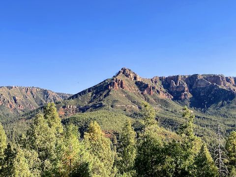
The Geronimo Trail #240 – East Webber Trail #289 hike starts at the Geronimo Trailhead, just outside the gate of Camp Geronimo (a Boy Scout facility). It’s been quite awhile since I last hiked out of the Geronimo Trailhead, on Airborne Day, 2015.
I’ve planned to hike Geronimo Trail #240 and East Webber Trail #289 for a couple of years, however I’ve been saving it for later in the season, hoping to see some fall color at the bottom of the Mogollon Rim. Last week, hiking the General Crook Trail, I could see spots of fall color 1,500 ft. below. This week, I finally pulled the trigger. 🔫
You can drive in via Houston Mesa Road / FR 199, but my wife & I continued north out of Payson, then cut over on Fire Control Road / FR 64. Fire Control Road is quite twisty. Early in the morning, it was no problem, although on our way back out, we had to dodge two tools who were driving left, and too fast.
Because Camp Geronimo is signed “no trespassing”, the Geronimo Trail #240 – East Webber Trail #289 hike loops two-thirds of the way around the Boy Scout camp. There is no low-slope short trail along the third side of the triangle. (A loop can be made of BSA Rim View Trail, but the loop is a mile longer and, at last report in 2020, significantly overgrown.)
From Geronimo Trailhead, hike south across FR 440 and Webber Creek, onto singletrack Highline Trail #31. It climbs 80 shady feet in ¼ mile. Turn right at the fiberglass “Trail -> 240” post. Geronimo Trail #240 twists & turns, generally northwest, climbing another 270 ft. in the next ¾ mile.
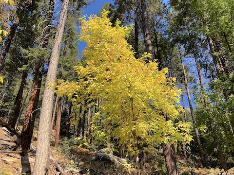
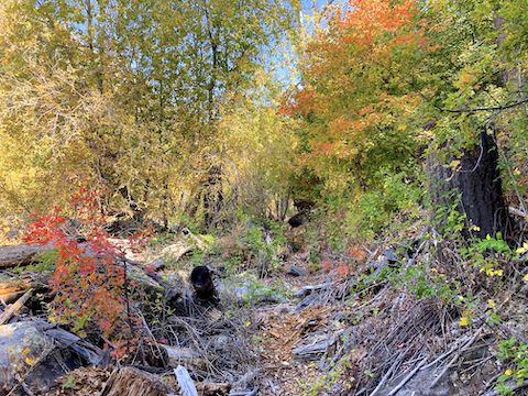
The only confusing bit of Geronimo Trail #240 is 1¾ miles out: The trail looks like it turns left & up, yet it actually turns right & down, towards Camp Geronimo. At the gate, then you turn sharp left. The fall color starts at the top of the climb, and continues to the 2-mile mark at Turkey Springs Trail #217. 🍁
If all you want is some fall color, turn around now, for a four mile, 575 ft. AEG out & back hike.
At the Turkey Springs Trail #217 sign, turn right to stay on Geronimo Trail #240, which continues to switch between singletrack and narrow jeep trail for one more mile . Facing the mid-morning sun, there isn’t as much shade either. ☀️
East Webber Trail #289 starts just past the 3-mile mark. I misinterpreted the signs, and soon found myself heading downhill. I doubled back. Instead, turn left at the “East Webber Trail 289 –>” sign.
East Webber Trail #289 begins a steady climb, the slope gradually increasing. It gains 900 ft. in two miles. (According to the topo, the trail gains 700 ft. more, to the top of the Mogollon Rim, in a further ½ mile to the Lee Johnson Spring.)
East Webber Trail #289 is all singletrack, often indistinct, with regular deadfall. Some quite large. Plus roots and rocks. I climbed over some deadfall, and ducked under others. In other words very similar to one of the canyon crawls I do on top of the Mogollon Rim. It’s physical going down canyon. Even more so going up.
Along the way, I saw one old & faded engraved wood “Webber” sign; two engraved yellow arrow-shaped “Spring” signs; and a stack of two signs announcing “FSTR 289 East Webber <—->” and “BSA TR Rim View”. Despite the signs, I got off trail twice. 🤦🏻♂️
East Webber Trail #289 crosses Webber Creek multiple times. Though water was running, I was able to cross dry each time. About a mile up 289, there is a really nice little pool, that is deep enough to sit in. An in & out hike to the pool would be 8½ miles, 1,135 AEG.
Before the 5-mile mark, I decided I’d had enough. No need for another Willow Springs Canyon. I didn’t realize at the time, the spring is only another ⅓ mile up Webber Creek. Kind of bummed in retrospect. I could have made it. But I had exercised, and that is always my main objective. Words of Wisdom: Always turn back before you are exhausted.
I bailed back down East Webber Trail #289. Without realizing it, I continued towards the second Camp Geronimo gate. I didn’t feel like doubling back a second time, so over the gate I went. I figure somehow straining my left pectoral was fair payment for the transgression. 😫
Damn, Camp Geronimo is huge. And nice. Multiple clean looking outhouses and toilet buildings. Much nicer than the Bear Paw Boy Scout Camp my Army Reserve unit would spend a drill weekend at every September. After hiking over four hours, I hiked the 1¼ road miles through Camp Geronimo in only 25 minutes. For once I made it back to my wife on time!
Directions: From Phoenix, head north on AZ-87, the Beeline Highway, through Payson. 10 miles north of Payson, about a mile before the town of Pine, turn right onto Fire Control Road / FR 64. In 5.5 miles, turn left onto FR 440. In a ¼ mile, turn left to stay on FR 440. In 1.6 miles, before entering Camp Geronimo, park at the Geronimo Trailhead.
GPS File: Geronimo_Trail_240_East_Webber_Trail_289
Distance: 8.75 miles
AEG: 1,308 ft.
Time: 3h 36m