

Bear Canyon is located atop the Mogollon Rim, just a ½ mile directly north of Christopher Creek and See Canyon Trail #184. Bear Beaver Ridge is on its west flank; Bear Willow Ridge to the east. (On the Rim, ridges tend to be named after the two canyons which border them.)
Bear Canyon is dammed two miles north of Rim Road / FR 300, forming Bear Canyon Lake, which I hiked around last year. Today, my plan was to hike from the dam, north to Mule Crossing, at the confluence with Willow Creek, then double back along FR 84B Willow T.S. Spur and decommissioned FR 92A1. (Even an easy canyon crawl is tiring headed up canyon; I prefer to avoid out & back hikes; and I’m scouting easily strollable roads for when I am too old for vigorous hikes.) 👴🏻
It was a frustrating drive up to the Mogollon Rim, with the most hair-pulling occurring following a Forest Service vehicle from AZ-260 nearly all the way to FR 34. She was driving 20 mph on dirt, swerving, and even occasionally brake stabbing. Obviously had never driven on dirt before. Did I mention she was Forest Service?
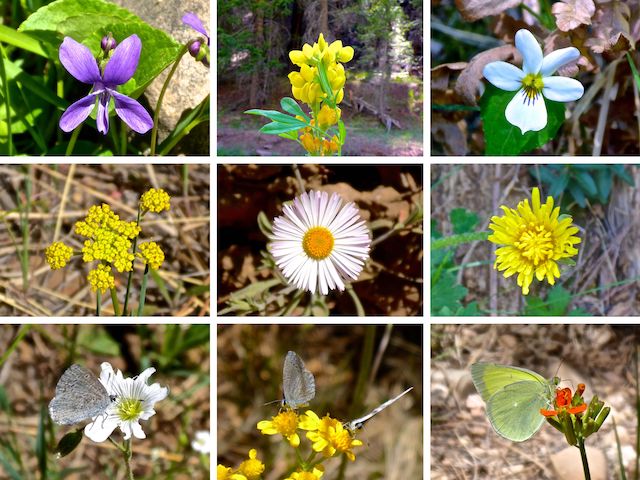
Top Row: northern bog violet, spreadfruit goldenbanner, Canada violet.
Middle Row: alpine false springparsley, spreading fleabane, dandelion.
Bottom Row: field chickweed & New Mexico groundsel (both with spring azure butterfly), western wallflower (with Queen Alexandra’s sulphur butterfly).
I finally started hiking around 9:00 a.m. From the Mallard Trailhead, the trail switchbacks down, 300 yds. to Bear Canyon Lake. Turn left (north) onto Bear Canyon Lake Trail #112, which hugs the bluff for another 300 yds. to the dam’s spillway. Mind your footing along the bluff, and crossing the logs that jam the spillway. Rather than descend the very steep concrete spillway, take the gravel path down.
The gravel path descends to a flat between the spillway to the left, and a creek to the right. I went left because there was a rock “bridge” and a little more space on the Bear Canyon bottom. I followed a human foot trail for the next ½ mile. There were so many beer cans — mostly Bud Light, of course — that I didn’t bother picking any up. I did pick up other garbage, though. ♻️
Bear Canyon’s bottom has water for about a mile north of the dam. Some pools, some more creek-like. One to six feet wide; up to 6″ deep. But no flow. The canyon bottom was dry the next two miles. The final mile to Mule Crossing had pools again — one was 20 ft. x 50 ft. and a good 18″ deep — with some light trickle.
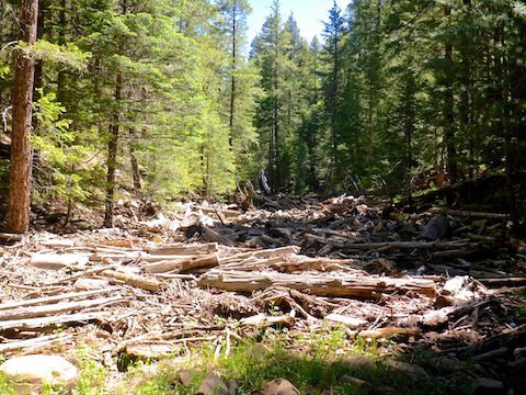
Trying to walk across the Bear Canyon log jam is a guaranteed ankle snapper. The log jam is easily avoided. (I went right.) I hoped the jam meant less deadfall down canyon, and for the most part that is true. I low-crawled once: I stood up too soon, and got stabbed in the neck by a sharp branch stub. Thankfully, no arteries were penetrated.
The only other bloodletting threat in Bear Canyon were mosquitoes, and I didn’t see any north of the log jam, not even when the canyon got wet again. Other critters I encountered were a few lizards, the usual scattered bones, and quite a few butterflies: The ones that stayed still long enough to photograph were the spring azure butterflies and Queen Alexandra’s sulphur butterfly shown above. 🦋
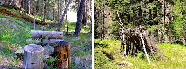
I found a number of unusual objects in Bear Canyon: The first, a ½ mile north of the dam, on the east shelf, was what I thought at first was a booby trap made of short, staked, logs. Not sure though. A ½ mile further down canyon, I found some fallen branches tied in a X with parachute cord. Finally, in a clearing ¾ mile south of Mule Crossing, I found a lean to.
Oh! I forgot to mention that this Bear Canyon is different than the other Bear Canyon, which is 12 miles west, also atop the Mogollon Rim. Not sure why there is more than one. Maybe because the other Bear Canyon is in the Coconino National Forest, and this one is in the Apache-Sitgreaves National Forest. And has a lake.
A ¼ mile north of the log jam, Bear Canyon passes under a high tension powerline. It’s an open area, roughly 100 yds. wide, so any possible shortage in the powerline doesn’t spark a wildfire. The Bear Fire, which ignited three days prior to my hike, ¾ mile northwest, was started by humans. Luckily, it was out by the next day, having burned only 15 acres. 🔥
There are several possible bail points along Bear Canyon. I marked one, which has animal trail west, up a spur, a ½ mile north of the powerline. That option is 2.0 miles, 300 AEG, back to Mallard Trailhead via FR 89A3. Another hiker I know, bailed east — a steeper climb — to FR 84B, near that point. That option is 3.0 miles, 400 AEG, back to Mallard Trailhead.
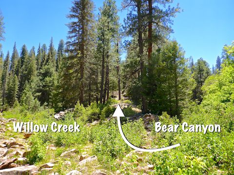
The middle two miles of Bear Canyon are often rocky. Though still hikeable, I took what shelves were available, and there were plenty. I never strayed more than 20 ft. upslope. I did get confused at Mule Crossing, first starting to follow FR 89, then contemplating the wrong spur to exit the canyon. The correct spur (above) is a 180 ft. climb in a mostly brush free ⅒ mile. I made it in seven minutes.
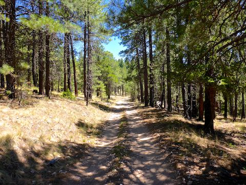
FR 84B, at the top of the climb, is the halfway point of the hike. The forest road is covered in about an inch of dust. With one small exception, it is easily SUV-able as far south as the powerline. I saw tire tracks south of the powerline on FR 92A1, where the Forest Service says it is no longer legal to drive. (Yet there were no signs.) Other than a short stretch of forest clearing, there was plenty of shade. 🌲
A ¼ mile north of Bear Canyon Lake, the forest road splits. Go right, through a locked heavy gate, down to the dam, then backtrack to the Mallard Trailhead.
It was around 3:30 p.m. when I finished, so rather than stop at Woods Canyon Lake for Good Humor ice cream, we headed straight into Payson, hitting Culver’s for dinner and their Flavor of the Day: chocolate custard with M&Ms, Oreo bits and Dove Chocolate drizzled with chocolate syrup. 💉
Directions: From Phoenix, head north on AZ-87, the Beeline Highway, into Payson. Turn right on AZ-260. In 29 miles, after cresting the Mogollon Rim, take the first left onto FR 300 / Rim Rd. In 3.2 miles, at the Woods Canyon Lake intersection, Rim Rd. changes to car-drivable dirt. 9.4 miles from AZ-260 is a t-intersection. Turn left. (Right is FR 34 to Winslow.) In 3.3 miles, turn right onto FR 89. In 2.0 miles, turn right onto FR 89A. In a ½ mile, stay left at the split. The Mallard Trailhead is by the pit toilet.
GPS File: Bear_Canyon_Loop
Distance: 11.38 miles
AEG: 759 ft.
Time: 4h 51m
Hiking Video
Hiking Bear Canyon to Mule Crossing from Preston McMurry on Vimeo.