

Heading east from Dewey, this is the 4th segment of General Crook Trail.
I haven’t being doing enough elevation gain on my hikes to tackle the first V segment of General Crook Trail #130, from Clear Creek Campground (V6) to Upper Sawlog Tank #1 (V16). It’s 3,800 ft. accumulated elevation gain (AEG) in just under 10 miles. The next segment, the one I did, is 1½ miles longer, but “only” 1,700 ft. AEG.
As the General Crook Trail makes it’s way from Ft. Whipple, in Prescott, to Ft. Apache, it is renumbered as it passes through the Prescott National Forest (Trail #64), Coconino National Forest (#130) and Apache-Sitgreaves National Forest (#140).
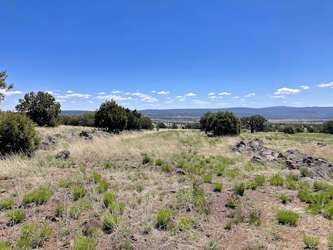
The fourth segment starts just north of AZ-260 milepost 237. I hiked ½ mile up rocky FR 9243D, past Upper Sawlog Tank #1, then split right onto General Crook Trail proper. I stopped at Upper Sawlog Tank #1, which was maybe 50% full. The tank had decent views 17 miles southwest to the Pine Mountain Wilderness.
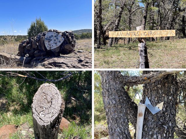
A gabion is a caged stack of rocks. The Boy Scouts used them to mark the General Crook Trail’s path in 1976. Every mile was marked with a 24″ high log, 4″ diameter, with the mileage etched into the angled top, and painted white. Many of the posts and gabions have gone missing. Of the gabions that remain, some have fallen. In all, I found 30 gabions, the V21 mileage post, and several chevrons.
The modern day General Crook Trail often follows dirt forest road, but there were several miles on the fourth segment that were cross-country. Though occasionally rocky, cross-country was never difficult. The gabions helped. To avoid cluttering up the attached GPS route, below, I’ve only included eleven gabions and three chevrons. 🛰
Some of the General Crook Trail gabions have a sign shaped like a triangle with curved sides (known as a Reuleaux triangle). Auto mechanics will recognize the shape from a rotary engine; musicians a guitar pick. The paint on the signs has faded over the last 47 years, but they once read “Nat. Recreation Trail – General Crook”.
I spotted the first gabion as I turned off FR 9243D onto General Crook Trail #130, which at that point is more rocky jeep trail. The trail gradually becomes fainter as it follows the shallow upper reaches of Devil’s Windpipe (a canyon). After crossing FR 9248A, the trail disappears. It took me a few minutes to figure out I should continue southeast, towards the top of Mud Tanks Mesa. 🤔
The next ¼ mile downhill off Mud Tanks Mesa is still cross-country, but then I picked up the old General Crook Trail roadbed pictured above. I followed the roadbed to a fenceline near Road Tank. The fence is the only one on this segment without a gate. The bottom strand was not barbed, so I low-crawled it. The old roadbed peters out as you approach AZ-260 at the 4 mile mark. (It’s probably under pavement.)
The remainder of this General Crook Trail segment is never more than 300 yds. from AZ-260, and sometimes as close as 50 ft. On Thursday afternoon, traffic wasn’t bad, and didn’t harsh my mellow. Nor did the grass, which was actually grass-like, not stabby & aggressive cheatgrass / foxtail. That would have sucked.
There is a tree line along the east side of Mud Tanks Draw. The shade was a short, but welcome, relief from the otherwise exposed pinyon & juniper grassland General Crook Trail #130 traverses. Apron Tank, at the intersection of Mud Tanks Draw and AZ-260, was little more than a mud puddle. Apron Tank is good turnaround / pickup point, with easier access than where I started on FR 9243D.
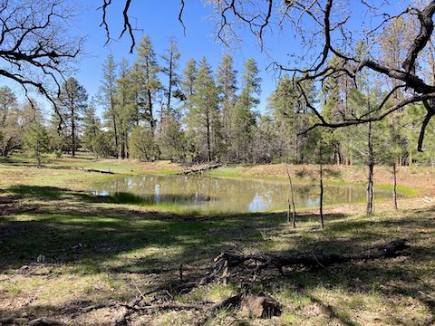
Though unnamed, the tank on Tin Can Draw was nearly full, dotted with reeds, and surrounded by plenty of shade. Removing my shoes & socks, I took a 20 minute lunch break. After airing out my dogs, I began the second of three 400-500 ft. climbs on this General Crook Trail segment, along the south slope of Salmon Lake Butte. (The first was Mud Tanks Mesa.) The climb was shady, but brushy. 🥪
Red & yellow pea were the most common flower throughout this hike. Doubting mariposa lily — which I thought were sego lily — near Upper Sawlog Tank. Great clusters of longleaf phlox. Hairy golden aster, yellow evening primrose, desert biscuitroot, western wallflower on the slope of Salmon Lake Butte, ashen milkvetch, and dandelion. Plus others I could not identify. Maybe 20 species in all.
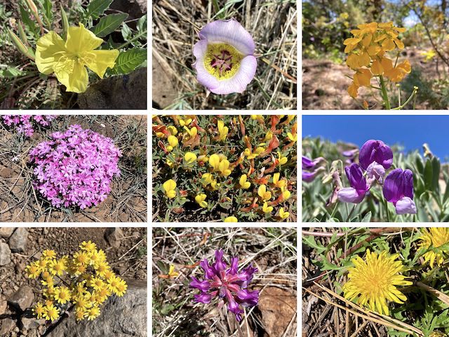
Top Row: yellow evening primrose, doubting mariposa lily, western wallflower.
Middle Row: longleaf phlox, red & yellow pea, {unknown}.
Bottom Row: hairy golden aster, ashen milkvetch, dandelion.
After Salmon Lake Butte, General Crook Trail crosses a shallow valley along dirt Tom’s Creek Rd. Now in ponderosa pine, most of the next three miles have spot shade. Just past Meadow Canyon Tank, Tom’s Creek Rd. turns right to AZ-260. Instead, bend left onto FR 9246R. In 150 yds., on the right, is a chain latch gate. Pass through it. I had to excuse myself as someone had parked his fifth wheel there. 🙄
The next mile of General Crook Trail #130 is on unnumbered jeep trail. (According to an informal sign, with letters made of screws, “Manchitas Circle Dr.”) Halfway up the third climb, near Juniper Tank, as the path peters out, turn right, continuing to pick out the gabions and, now, tree-mounted chevrons. Once again close to AZ-260, and on jeep trail, there is a mile to go.
I arrived at FR 9361K in a hair under seven hours, five hours moving time (2.60 mph). Not bad, considering all the times I stop to take pictures. After a change of socks, and street shoes, and a sodium replacing V-8 it was back into Phoenix to hit up my Wisconsin home boys, Culver’s, for my first cheese curds of the summer hiking season!
Upper Sawlog Tank #1 Directions: From Phoenix, head north on I-17. Take exit 287 east onto AZ-260 through Camp Verde. In 18.5 miles, near the top of the climb, just 100 ft. past milepost 237, in the middle of a right hand curve, instead turn left onto FR 9243D. Park right there, or if you have a 4×4, continue up FR 9243D for 200 yds. to Upper Sawlog Tank #1.
FR 9361K Directions: Continue east on AZ-260 for 10.5 miles. After milepost 247, but before 248, on the left is FR 9361K. Park just off AZ-260. It’s easy to miss, so make sure to download the GPS route below, and have it turned on as you drive along AZ-260.
GPS File: General_Crook_Trail_V16_V27
Distance: 12.76 mi.
AEG: 1,712 ft.
Time: 4h 55m
Hike Video
Hiking General Crook Trail: V16-V27 from Preston McMurry on Vimeo.