
, not silverleaf nightshade (Solanum elaeagnifolium), as the latter bloom later, at lower elevation. This is about 3,250 el., near Sears Kay Ruins.")
Counter-clockwise from Bronco Trailhead, this is the 25th segment of the Maricopa Trail.
In the intro for the previous Maricopa Trail video, I said Granite Mountain Trailhead to Bartlett Dam Rd. was the penultimate segment. And it is. But the final segment is 12¼ miles and over 2,200 ft. accumulated elevation gain (AEG). Because I tend to wander, and backtrack, my stats would be even greater. So, I decided to split the final segment in two.
Tonto National Forest road FR 1058 crosses the Maricopa Trail 4⅔ miles north of the Cave Creek Ranger Station on Bartlett Dam Rd. From the Maricopa Trail, it is 1½ miles on FR 1058 to Cave Creek Rd. I didn’t want my shuttle-driving wife to make the drive in before I had a chance to scout FR 1058 on foot.
My wife and I arrived at the Cave Creek Ranger Station gate on Bartlett Dam Rd. around 7:00 a.m. It was closed. A few minutes later a pickup drove through the gate, so we figured the station was open, and followed. It wasn’t. The gate closed behind us. Oh well. 🤷🏻♂️
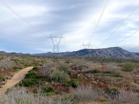
This segment starts at the ranger station’s detailed map board shown in my hike video (below). It was cloudy and chilly. Hike southeast for ¼ mile. After passing under the powerlines, the Maricopa Trail turns north. I thought the powerline road continued north, but instead the Maricopa Trail is doubletrack, rolling up & down, side-to-side, crossing many small washes, to the 2-mile mark.
I had brought two batteries, but the first one was only charged to 27%. Between two batteries, I figured my GoPro had power for maybe two hours, so I was hauling ass.
At the two mile mark, the trail splits: Go right, away from the powerline. (You can’t go wrong following the Maricopa Trail signs.) The Maricopa Trail descends 380 ft. in a mile to Camp Creek. I jogged a good chunk of that, trying to beat my lack of battery power. 🔋
Camp Creek is a four-way wash intersection: Camp Creek Falls is a quarter mile north. Blue Wash is northwest. (It is just over a mile up Blue Wash to Cave Creek Rd.) Southwest is the unnamed wash you just descended. Camp Creek flows downstream to the southeast.
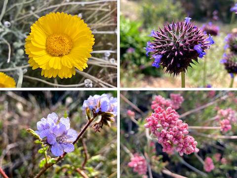
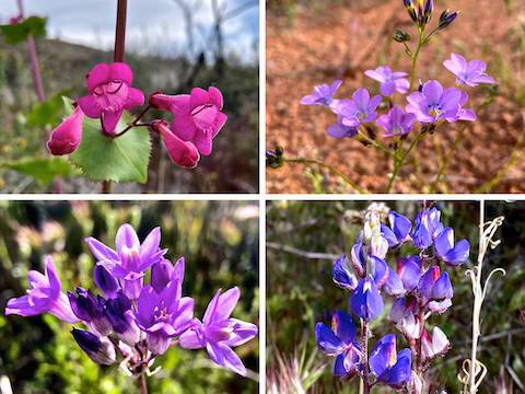
Besides the flowers pictured in this blog, I saw some very nice patches of plains blackfoot, red & yellow pea scattered along much of the Maricopa Trail, threadleaf groundsel, arizona popcornflower, silverpuff, fiddleneck, and invasive stinknet. The Arizona popcornflower (Plagiobothrys arizonicus) were a first for me, but my photos were regrettably blurry. Wildflowersearch.org is a big help!
Maricopa Trail makes a steep little climb out of Camp Creek, before the grade becomes more moderate. Overall, the trail rises 400 ft. in a mile. The best views on this segment are along this spur. At 4¼ miles, there is a trail split: follow the signs left, switchbacking down 100 ft. to cross a fairly large wash.
From the wash, Maricopa Trail switchbacks up 130 ft. in a quarter mile to FR 1058. Though I was done with the segment, I was only two-thirds done with my hike: I still had almost two miles to hike on FR 1058 to Sears Kay Ruins. It’s a good thing I did.
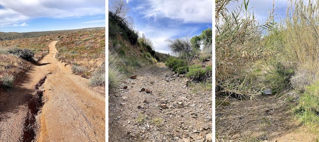
FR 1058 down to Camp Creek had a smooth surface, but was still slippery. And steep. After a half mile, there is a heavy Forest Service gate. It looked locked, but wasn’t. The next quarter mile isn’t as steep, but is rocky. The Camp Creek crossing is heavily overgrown: The vegetation is flexible and not scratchy. Water flow was steady, but not too deep or heavy. The next 50 ft. up out of the creek are even rockier.
FR 1058 then crosses the main part of Sears Kay Ranch. I heard some work going on, but saw no one. There’s a steep climb out of the main ranch area, in the middle of which is a second apparently locked — but actually not — gate. For folks driving east from Cave Creek Rd., there is also a “private property – no national forest access” sign. Crossing back under the powerlines, there is a large pullout. From there I followed random trails from FR 1058 to Sears Kay Ruins.
My GoPro power ran out just before I left FR 1058, so I got all the important footage I needed.
Afterwards, I called the Tonto National Forest to ask about FR 1058’s status where it crosses Sears Kay Ranch. They confirmed the bit within the ranch’s boundaries is in fact private property. I’ve done the whole Maricopa Trail counter-clockwise, but this segment may be one I should have done the opposite, from Bronco Trailhead to Cave Creek Ranger Station. 🤔
I’ve now completed 235.52 miles of Maricopa Trail. For sure, now, only one segment to go!
Cave Creek Ranger Station: From Loop 101 / Pima Freeway, take exit 36 north onto Pima Rd. Head north for 12.1 miles. Turn right on Cave Creek Rd. In 4.2 miles, turn right on Bartlett Dam Rd. In a quarter mile, turn left into the Cave Creek Ranger Station parking lot.
FR 1058 Trailhead: Honestly not sure about this one. You could drive FR 1058 from Horseshoe Dam Rd. / FR 205, but it looks rough on satellite view. It’s also a long way around from there up to Bronco Trailhead. Or you could park at the powerline pullout, then hike around the ranch’s boundary, using a wash that skirts the ranch’s southern tip. Up to you. 🤷🏻♂️
GPS File: Maricopa_Trail_Bartlett_Dam_Rd_to_FR_1058
Distance: 6.84 mi.
AEG: 935 ft.
Time: 2h 16m
Rumble Video
Vimeo Video
Maricopa Trail: Bartlett Dam Rd. to FR 1058 from Preston McMurry on Vimeo.