

My wife and I have been visiting our younger son, Jason, and his family in Hagerstown several times a year since 2010. Our autumn visit is for Halloween. This year Halloween fell on a Tuesday, so we flew into Baltimore on Friday, rather than our normal Thursday. Peak fall color in western Maryland is mid-October, but it still looked decent as we drove west along I-70.
Jason and I planned to hike from Keifers Lock 75 in North Branch (MP 175.7) to Canal Place in Cumberland (MP 184.5) on Saturday. Jason’s been putting in the miles around Hagerstown, and this would have been our first ever hike together. It was not to be. I got up so early on Friday (12:15 a.m.) to make our flight out of Phoenix, that I did not have the energy on Saturday. That night it rained. 🌧
* We finally got our hike in next March.
It wasn’t until Monday that I was able to hit the Chesapeake and Ohio Canal towpath. In just those 72 hours, Allegany County lost significant color. Bummer. And I was hiking alone. Oh well. Onwards!

Top Row: chicory, dandelion, some kind of aster.
Bottom Row: some kind of honeysuckle, wild bergamot, common blue aster.
MP 175.7: Keifer’s Lock 75 — aka North Branch 3 — has a portapotty, four picnic tables (each with a grill), and a mapboard. Though 60℉, it was chilly, overcast and threatening. The “green slime” / duckweed that covered the water of Keifer’s Lock 75 in August had disappeared.
As I hiked west on the C&O Canal, I could hear shooting to my right. It didn’t sound frantic, so not an escaped prisoner from FCI Cumberland. Turns out the Allegany County Sheriff’s Office has a small range off Pittburgh Plate Glass Rd. Worse was to my left, a horrendous feed lot smell. (What I tease my wife as smelling like “profit”.) Unlike Opequon Junction, no cows, just tarp-covered piles of cow pies. 🥧
MP 176.5: Next to the C&O Canal was a sign announcing the Historic Pollock Cemetery, 75 yds. across a fallow field. The gate was locked, but the cemetery was small enough I could still get photos of the graves. Only 19 graves, the cemetery has known burials from 1883-2013. While I was walking around, a car drove up, and the driver just sat there watching me. When I left, he left. Spooky.
MP 177.0: I was hoping FCI Cumberland would be closer to the C&O Canal, like FCI Phoenix is to the Black Canyon Trail, just so I would could take a photo of something besides the towpath. But the prison is barely visible through the trees, as the towpath wraps around it for the next mile to this segment’s only rest bench. The Mexico Farms community to my left had large properties and horse lots. 🐴
MP 179.0: After crossing Mexico Farm Rd., Canal Rd. and Brehm Rd., CSX’s massive, 3½ mile long, rail yard begins. (Otherwise know as the Cumberland Terminal Subdivision.) I could hear the trains clanking, and engines blowing their horns but, like the prison, the rail cars were barely visible through the trees, across the water-filled C&O Canal, and up a 30 ft. embankment. So, no train graffiti.
After being out of sight since Irons Mountain Campground (MP 175.4), the Potomac River hoves into view a half mile before Evitts Creek Campground.
MP 180.0: Evitts Creek Campground has a portapotty, picnic table, grill, fire pit, direction & distance sign, trash bag dispenser, and a well hand pump — which not only had a handle, but gave water after only two or three pumps. It might be good for an overnight family fun camp, but this close to the end, why stop? 🤷🏻♂️
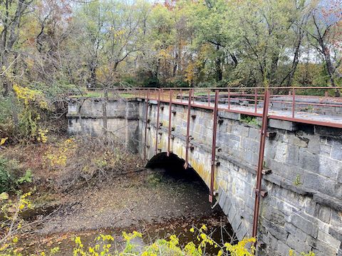
MP 180.7: Evitts Creek Aqueduct which, naturally, is over Evitts Creek, is the smallest of the C&O Canal’s twelve aqueducts. It’s crumbling 70 ft. arch of fossiliferous Tonoloway Limestone is reinforced with iron bars. Dammed at its south end, Evitts Creek Aqueduct is crossed by the towpath. (Conococheague Aqueduct is the only one I recall that still carries water.)
MP 181.5: The C&O Canal passes by Cumberland’s sewage plant, which smelled considerably better than the “profit” back by Keifer’s Lock 75. (If you ever get chance, sewage plant’s are a fascinating tour.) The Gene Mason Sports Complex is across Offut St. from the sewage plant. It’s relevance to the towpath is that it has actual bathrooms. The adjacent neighborhood had stunning fall color.
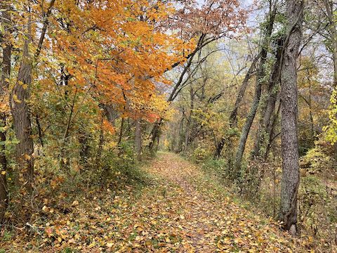
The best fall color I did photograph was visible on Knobley Mountain where the C&O Canal passes under MD-61 / Canal Parkway. The towpath turns north for the final stretch to Canal Place.
MP 183.0: The Carpendale Rail Trail intersects the C&O Canal. Carpendale Rail Trail is less than a mile, but packed with cool stuff: a 386 ft. wood bridge across the Potomac River, followed by a 1,500 ft. tunnel under Knobley Mountain to Carpendale, West Virginia. If I didn’t already have eight miles under my belt, I would have hiked it. 🚂
Hillcrest River Kampground is adjacent to the Carpendale Rail Trail. The kampground, a non-governmental field beween the towpath and Potomac River, has fewer amenities than the NPS “hiker biker campsites” downstream, such as Paw Paw Campground.
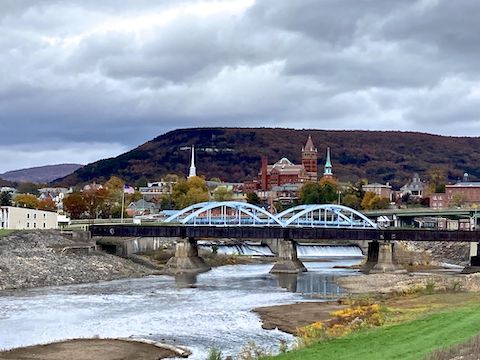
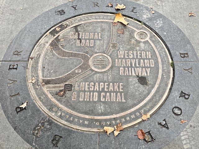
For the final mile, the C&O Canal is squeezed between the Potomac River, MD-61 and a half dozen CSX rail lines. Even at 2 p.m., it was chilly and windy. Canal Place was nearly empty. I was just glad I was able to find a place to eat — European Desserts & More — with my patient, shuttle-driving, wife.
Though not a thru-hike, it still feels good to finish section hiking a years-long project like the Chesapeake and Ohio Canal towpath. Next week, back in Arizona, I plan to finish the Black Canyon Trail. Next spring, the Maricopa Trail. And, next fall, the General Crook Trail. God willing. 🙏🏻
Lock 75 Directions: From I-68, take exit 43C to Downtown Cumberland. At the bottom of the ramp, turn left on Harrison St. At the next intersection, Canal Place (MP 184.5) is across the street. Turn left on Mechanic St., which becomes MD-51 / Industrial Blvd. In 6.0 miles, turn right on Pittsburgh Plate Glass Rd. In ½ mile, turn left into the North Branch trailhead.
Canal Place Directions: Double back the way you came!
GPS File: CO_Canal_175to184_North_Branch_to_Cumberland
Distance: 10.12 mi.
AEG: 127 ft.
Time: 3h 24m
Rumble Video
Vimeo Video
C&O Canal: Hiking North Branch to Cumberland from Preston McMurry on Vimeo.