

I planned to hike the Chesapeake and Ohio Canal towpath from McMahon’s Mill to Williamsport during Easter, 2022, but had to bail due to the path repairs along Big Slackwater. When I complete my C&O Canal segment hike this upcoming Halloween, I want the final segment to BE the final segment into Cumberland, so today I went back to pick up this missing link.
Easily the best flowers of this C&O Canal segment were the first mile west of McMahon’s Mill, where the path is squeezed between Big Slackwater and a ~70 ft. cliff. Where’s the canal? Big Slackwater. Actually in the Potomac River, because it would have been time & cost prohibitive for the Chesapeake and Ohio Canal Company to blast a canal prism through the cliffs. 🧨
The vegetation-choked cliff must trap Potomac River moisture, because I found at least six flower species in that mile, four of them new to me: bigroot morningglory (Ipomoea pandurata), narrowleaf evening primrose (Oenothera fruticosa), common soapwort (Saponaria officinalis) and rose of sharon (Hibiscus syriacus), plus dame’s rocket and woodland sunflower.

Top Row: bigroot morningglory, narrowleaf evening primrose, common soapwort.
Middle Row: rose of Sharon, white snakeroot, Pennsylvania smartweed.
Bottom Row: woodland sunflower, summer phlox, Asiatic dayflower.
MP 88.8: Lock 41 and, just past it, Lock 42. Together, the locks quickly drop the C&O Canal 19 ft., so canal boats could enter Big Slackwater, for the three mile trip down the Potomac River, before re-entering the C&O Canal at Guard Lock 4. When entering/exitting Big Slackwater, the towpath switched sides from right to left. I’m wondering how the mule teams switched sides?
After Lock 42, the Big Slackwater repairs detour rejoins the C&O Canal via Spring Dell Rd. Some cattle were ahead of me, that must have got loose from the farm up on Neck Road. As cattle do, they kept their distance, scattering ahead of me. Just before Opequon Junction Campground, all but a cow and her calf had disappeared. The calf actually turned and trotted towards me! The calf didn’t concern me, but I didn’t want to deal with mom, so I made myself small behind a tree. 🐄
MP 90.7: Opequon Junction Campground is small, with easy Potomac River access. It has a rest bench, portapotty, picnic table, fire pit, direction & distance sign, trash bag dispenser, and a well that gave water after only eight hand pumps.
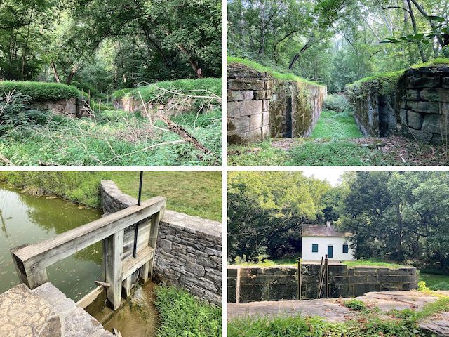
MP 93.0: Lock 43. The Lockhouse is 8 ft. lower than the towpath, on the landward side of the C&O Canal. It’s odd it would be so low, like it would be prone to flooding. Behind Lockhouse 43 is a leafy path that parallels the canal. Probably old railroad bed. Continuing uphill from the path, is a jeep trail that appears to give access to Acorn Way and Big Bend Way.
A ¼ mile past Lock 43, the towpath turns to gravel road as it enters the Potomac Fish & Game Club. They don’t have a website, so I’m not sure if it is private only, or how much membership costs. The lots are occupied by fifth wheels, mobile homes, modular homes and cinder block bungalows — some covered by RV carports. There’s a large cabana that looks like the one where Jim Jones handed out KoolAid.
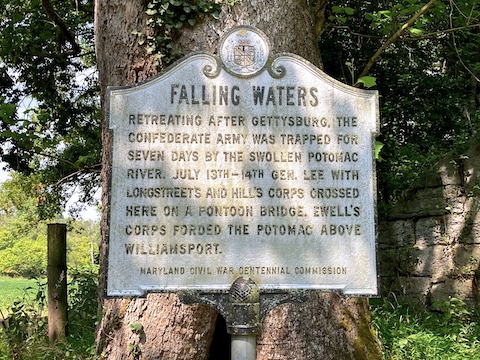
MP 94.4: Falling Waters marker, where Lee completed his retreat from Gettysburg on July 14, 1863.
MP 95.2: I didn’t explore Cumberland Valley Campground, as it was occupied, but it had all the usual free campground amenities: portapotty, picnic table, fire pit, grill, direction & distance sign and trash bag dispenser. Nor did I test the well hand pump, but it must work as the concrete base was wet. As of Spring, 2023, all C&O Canal well water is non-potable. I was wondering why that changed …
MP 96.6: A wood bridge crosses the C&O Canal to a dirt road, which appears to lead to Beagle Club Ln. There are railinged stairs from the towpath down to the Potomac River. (Often, even at campgrounds, there is a steep & slippery dirt path instead.) After seeing no flowers for two hours, I found Pennsylvania smartweed among the weeds & reeds on the Potomac River’s rocky shore. 🏞
I didn’t see a lot of flowers the last two miles to Williamsport, but it did some what pick up, with summer phlox, joe-pye weed and Asiatic dayflower. Thanx to Maryland Biodiversity and Wildflower Search!
MP 98.1: For miles, I had been hoping to find a second bench, to stop for lunch. Here it was. After I was done eating. Of course. The I-81 bridge over the Potomac River is a ¼ mile past the rest bench.
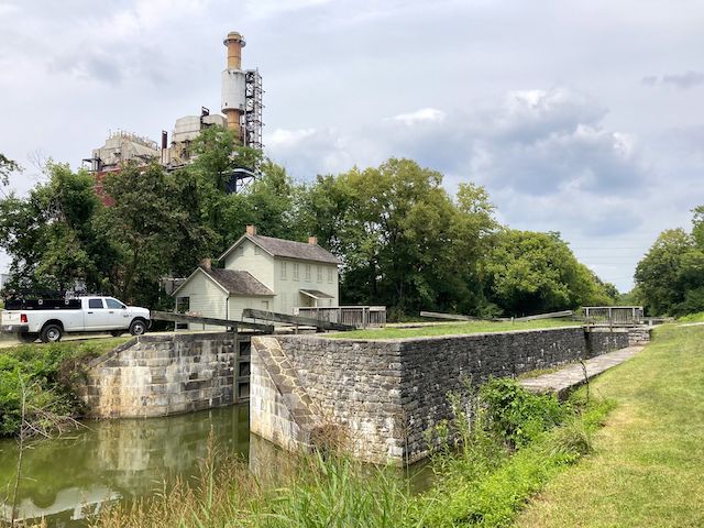
MP 99.1: It seems like C&O Canal locks near major towns are better preserved, and more watered, than those that are isolated. Lock 44 is no exception. For more info, see Locks on the Chesapeake and Ohio Canal. A ⅓ mile past Lock 44 is the rusty railroad lift bridge which connects the C&O Canal towpath, across Cushwa Basin, to the big red barn that is the Williamsport Visitor Center. 🚂
I’ve built up quite a library of music I’ve used on my ~800 videos. I try to find something new each week, but after spending hours, and finding nothing appropriate, dip into the library and re-use a tune. But always at least three years old, and never for a hike in the same area. You might recognize this week’s tune, “Man of Constant Sorrow”, from “O Brother, Where Art Thou?”, where it was performed by The Soggy Bottom Boys. Personally, I prefer the Howie Mitchell version that I last used in 2016. See below.
McMahon’s Mill Directions: From Hagerstown, or points east, take exit 28 off I-70 at Downsville Pike / MD-632. Head 5.5 miles south, through the hamlet of Downsville. Turn right on Dellinger Rd. In 0.5 miles, take the first left onto Avis Mill Rd. The trailhead is in 0.7 miles.
Williamsport Visitor Center Directions: From I-81, in Maryland, take exit 1 north onto Conococheague St. In 1.0 miles, turn left on US-11 / Potomac St. At the bottom of Potomac St., where it bends left, instead continue straight into the visitor center parking lot, which is marked by the old-time red brick building with the Cushwa’s sign.
GPS File: CO_Canal_MP88to99_McMahons_Mill_to_Williamsport
Distance: 12.79 mi.
AEG: 251 ft.
Time: 4h 21m
Hiking Video
Hiking C&O Canal: McMahon’s Mill to Williamsport from Preston McMurry on Vimeo.