

My typical schedule when visiting family in Hagerstown, is to fly in to Baltimore on Thursday, hike on Friday (while everybody is at work / school), visit on Saturday and Sunday, do a second hike on Monday, then fly back to Phoenix on Tuesday. That schedule maximizes family time, while also giving me time to rest between what is usually one of my longer hikes of the year.
My Halloween 2021 plan was to pick up where I left off last Easter, hiking 12 miles from from McMahon’s Mill to Williamsport on Friday, then 9 miles from Williamsport to Four Locks on Monday. But then it rained all day Friday, and into Saturday morning. What with the Chinese Lung AIDs panic still ongoing, the last thing I wanted to be was sick trying to get on a plane on Tuesday. 🚫🤒
So, I called an audible, instead hiking the shorter segment on Sunday, and planning to do the longer previous segment on Monday.
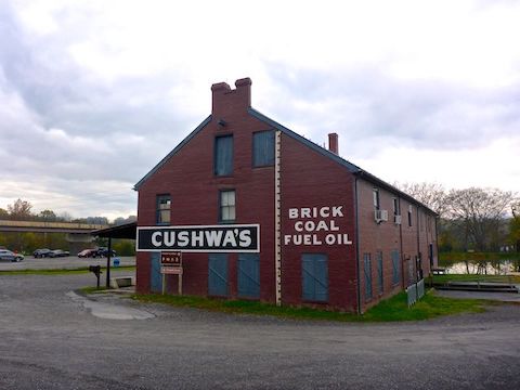
MP 99.4: The Williamsport Visitor Center, at Cushwa Basin, has a large gravel parking lot, picnic table, bike rack, two pit toilets and two portapotties (one handicapped), plus C&O Canal map & info signs.
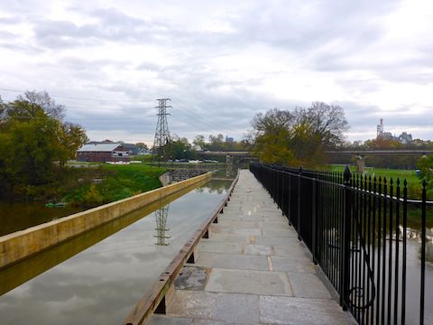
On satellite view — which tends to run about three years behind reality — Conococheague Aqueduct was under heavy restoration. I was not sure I would be able to cross it. You can’t, directly from the visitor’s center trailhead. Instead, as you face the warehouse, head left, under the US-11 bridge. Go up & over the metal skeleton of the old boat lift / lift bridge to Williamsport Park, then turn right to hike north on the C&O Canal towpath. 🛰
The restoration of the aqueduct over Conococheague Creek is not only complete, but the aqueduct is actually navigable — unlike other aqueducts back down the C&O Canal — though it would be a very brief kayak. The water ends at the Fenton Ave. access path. The canal to Four Locks is otherwise dry & brushy, with occasional swampy sections.
MP 101.2: I didn’t get a close look at the Jordan Junction Campground, because some shady rando was hanging out there, but it has the usual portapotty, picnic table, grill, direction & distance sign and doggie doo bag dispenser. Good thing I was carrying two bottles of water, as the well hand pump was missing its handle. Maybe the National Park Service removed it to prevent winter freeze damage?
MP 102.3: The Pinesburg Quarry is on top of a small bluff, on the landward side of the C&O Canal. I could see some old structures in it, but didn’t want to climb the bluff, and saw no easy way up. Probably best I didn’t, as it appears to still be an active operation. ⚒️
MP 103.3: There’s an old house on the landward side of the C&O Canal. Though farmland is often just the other side of the canal, that is not the case here. Neither is there a nearby canal lock. Nor a historical marker. The house is about to collapse, and not safe to enter. It’s chief advantage is using the back wall for a private whiz. Just past the old house, was the first of three Daofeng & Angela Foundation rest benches.
MP 104.8: Pilings for an old railroad bridge cross the Potomac River at Millers Bend. The rail line is not shown on any map, and the rail bed is not visible on satellite view. Unlike Old Rumsey Bridge, there were no historical signs. It’s just there. If you hear any shooting, it is coming from the West Virginia side of the river.
MP 105.6: Erosion has caused the Potomac River to encroach on the C&O Canal towpath, which here is separated by safety orange plastic webbing. Otherwise, despite 36 hours of rain, the towpath was in great shape. I saw lots of bikers, a few walkers, and one shirtless jogger. 🙄
MP 106.5: I could hear Dam 5 for a mile before I saw it. Dam 5 has a small gravel lot, a closed lockhouse, a portapotty, historical signs and a doggie doo bag dispenser. A shorter C&O Canal hiking option in this area would be a back & forth between Dam 5 and Four Locks (a 4.5 mile round trip).

Just past Dam 5, the towpath switches from its normal position on the Potomac River side of the C&O Canal to the landward side. I don’t recall see that before, except maybe in Georgetown, at the beginning of the canal. Then the canal disappears altogether, as the towpath hugs the cliff of a short ½ mile slackwater.
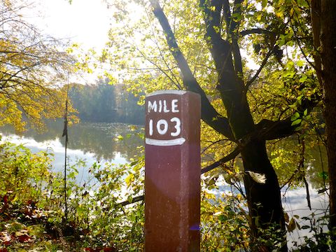
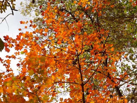
MP 107.4: The towpath returns to the Potomac River side of the C&O Canal at Lock 46, which has an interesting parallel culvert in its support structure. Lock 46 has a small grass parking lot, which is accessed via Ashton Rd. Fall color had been patchy at best, but from Lock 46 to Four Locks it improved, as I started seeing some decent orange, and even red, leaves. Prior to that, what leaves had color were mostly ripe banana colored. 🍂
MP 108.0: Charles Mill has been in the same family since it was built around 1790. Now with only parts of three crumbling walls remaining, it is on private land. If there is a physical milepost 108, I missed it while reading the mill’s historical sign.
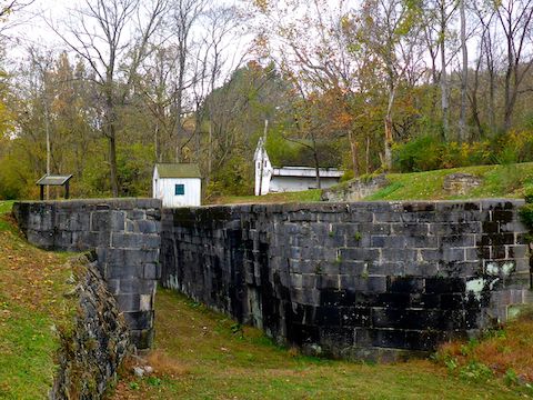
MP 108.5: Four Locks was a ⅔ mile cost-saving shortcut across the four-mile bend in the Potomac River known as Prather’s Neck. Built between 1836-1839, a small community of several dozen buildings soon grew up around Four Locks. Though now a ghost town, buildings still extant in Four Locks include the canal mule barn, Stone House, Denton Jacques’ warehouse, the lock keeper’s shelter, Lockhouse 49 and lesser ruins.
Lockhouse 49, which is available for rent as part of the Canal Quarters Program, is located in the middle, opposite Four Locks Landing (a large paved parking lot and boat ramp). The Four Locks area has a portapotty, pit toilet, doggie doo bag dispenser, rest bench, well hand pump (sans handle), C&O Canal info signs and multiple picnic tables & grills. 🌭
I felt good when I finished my hike, but between that and going trick-or-treating with my grandaugter Boo that Halloween night, on Monday, I was just not feeling it for a second 10+ mile hike in two days. So, I again need to recalculate my C&O Canal hiking segments so I can get them done in the next two years.
Williamsport Visitor Center Directions: From I-81, in Maryland, take exit 1 north onto Conococheague St. In 1.0 miles, turn left on US-11 / Potomac St. At the bottom of Potomac St., where it bends left, instead continue straight into the visitor center parking lot, which is marked by the old-time red brick building with the Cushwa’s sign.
Four Locks Directions: From I-70, take exit 18 north onto MD-68 / Clear Spring Rd. At the light, turn left on US-40. At the next light, turn left on Martin St., which becomes Big Spring Rd. Mind the one-lane bridge in the hamlet of Big Spring. In 2.4 miles, turn left on Four Locks Rd. In 0.6 miles, take a slight right onto Starliper Rd., which curls left under Four Locks Rd. to the boat ramp. Mind the two narrow tunnels along Four Locks Rd. and Starliper Rd.
GPS File: CO_Canal_MP99to109_Williamsport_to_Four_Locks
Distance: 10.78 mi.
AEG: 187 ft.
Time: 3h 33m
Hiking Video
C&O Canal: Cushwa Basin to Four Locks from Preston McMurry on Vimeo.