
.")
On Friday, I hiked the 16th C&O Canal segment from Bond’s Landing to Paw Paw Tunnel Campground. (Paw Paw Tunnel itself is currently closed at the north end due to landslide mitigation.) The day after Easter, I continued on, almost 11 miles to Oldtown.
MP 156.0: Paw Paw Tunnel Campground has 10 numbered spots, each with a picnic table, grill and fire pit. There are informational signs by the multiple frequently cleaned portapotties. (One is handicap accessible.) There is a well hand pump, but I did not check to see if it worked, or if it required filtering. Camping is $20 / night and reservations are required. Personally, I’d camp for free at Purslane Run. 😉
Though warmer than on Good Friday, it was still chilly when I started hiking at 9:45 a.m., wearing my hoodie. Head out the end of the parking area, then turn left (south) under MD-51. The C&O Canal towpath crosses under a Western Maryland Railroad bridge (MP 156.5). The cliff-hugging old railroad right-of-way continues to parallel the C&O Canal at least six more miles to Town Creek.

Top Row: common blue violet, dusky yellow violet, bloodroot.
Bottom Row: Eastern spring beauty, Persian speedwell, purple dead nettle.
MP 156.9: Purslane Run Campground is a normal C&O Canal towpath campground. And free. It has a portapotty, picnic table, grill, fire pit, direction & distance sign and trash bag dispenser. The well hand pump only took one pump before it gave water. Have I mentioned it’s free?
Did you know, the National Park Service “turns off” the C&O Canal campground well hand pumps from November 15 to April 15 each year? I didn’t. However, that does not explain the pump handles being locked on Halloween, two weeks earlier. 🤨
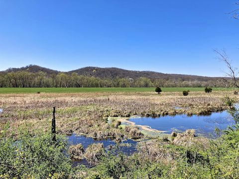
Just past Purslane Run Campground, is the first of many river flats & flood plains that used to be farmland. (If they were still in use, crops would be growing by now.) Besides shortening distance by cutting river bends, thus reducing construction & transportation costs, the C&O Canal was deliberately built as far — and “uphill” — from flood plains as possible, to avoid costly operational disruptions.
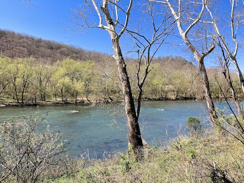
The C&O Canal’s mileposts, which are foot high, brown painted 4x4s with white numbers, placed every mile. There is not much else the first three miles of this C&O Canal towpath segment. I saw a number of rough looking trailers and cabins on both sides of the Potomac River. I assumed they were fishing camps. I heard no banjos.
MP 160.2: I learn something new every hike on the C&O Canal, and today I learned more than normal. What I thought when I passed by here was a culvert, is in fact a “waste weir”, which allowed canal operators to drain excess water from the C&O Canal. I also learned the proper name for a canal bed is “prism”, because the top canal of the bed is wider than the bottom, and thus prism-shaped. 📐
MP 161.7: Over the course of a century, every C&O Canal lock had multiple operators. Because the locks were named after their operators, each lock may carry multiple names. Per the National Park Service, this one is known as Darkey’s Lock 67, named after Hughey Darkey, whose four or five pretty red-headed daughters who were “much commented upon by the boatmen”.
MP 162.1: Town Creek Campground has a portapotty, two picnic tables, a grill, two fire pits, a direction & distance sign, a trash bag dispenser, and a well hand pump. There is grassy access right to the edge of the Potomac River, with beautiful views up & down stream. 📸
Just beyond the campground is Town Creek Aqueduct. A single-span aqueduct finished in 1850, it is made of sandstone and “bastard limestone”. (Probably named after the original contractor, who absconded mid-project — a not infrequent occurence in the C&O Canal’s early days.) The campground and aqueduct have parking access via Oldtown Rd.
The C&O Canal is dammed at Town Creek Aqueduct, so that the next two miles upstream are navigable by kayaks. Other than jillions of turtles on logs in the pond — which would slide into the water whenever I got close — there are few photographic opportunities until Crabtree’s Lock 68.
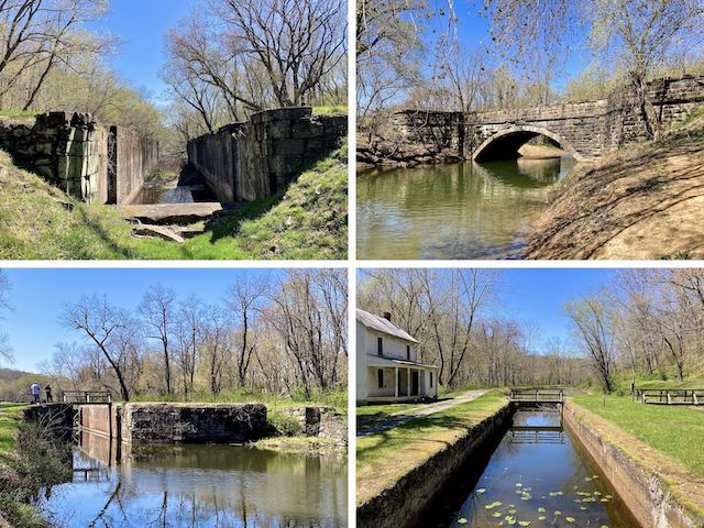
MP 164.7: Crabtree’s Lock 68 and Potomac Forks Campground can be seen just beneath the old road bridge that once connected French Station, WV, to MD-51 via Potomac River ferry. The portapotty and well-preserved lockhouse are tucked away on the river side. On the land side of the C&O Canal is a picnic table, grill and fire pit. Completely lacking mechanicals, the hand well pump is non-functional.
Somewhere along the C&O Canal’s Paw Paw to Oldtown segment, there is a nearby canal workers’ cemetery, but the only graves I could locate were Ahman Sorrells, by Lock 69, and the Kiefer Cemetery — where over the course of four weeks, in 1854, that unfortunate family buried three small children.
MP 166.4: After a bone dry patch, a fair number of folks were fishing the C&O Canal above and below Twigg’s Lock 69. Known as Battie Mixon’s Pond, it is stocked by Maryland DNR, and contains bluegill, sunfish, channel catfish, smallmouth bass, crappie, shiners and even trout. Visible just a few hundred yards ahead is Oldtown Lock 70, and the trailhead where I finished my hike.
Paw Paw Directions: From I-68, take US-522 south to Berkeley Springs, WV. Turn right on WV-9 / Cacapon Rd. The town of Paw Paw is in 24 twisty miles. Continue through town, across the Potomac River. A ½ mile past the river, turn right into Paw Paw Tunnel Campground.
Oldtown Directions: You could take MD-51 from Cumberland to Oldtown, but I find the roads in Cumberland confusing. Unless you are coming from “out west”, I would instead follow the above directions to Paw Paw. Just over 10 miles past the Potomac River, split left off MD-51 onto Opessa St. into Oldtown. In ¾ mile, turn left on Green Spring Rd. In 150 yds., before crossing over the C&O Canal, turn right into the trailhead. Ignore any GPS that tries to route you through the hamlet of Flintstone (I-68 exit 56): While a nice town, the roads are very twisty, and narrow, and pass right through multiple farms.
GPS File: CO_Canal_156to166_Paw_Paw_to_Oldtown
Distance: 11.75 mi.
AEG: 172 ft.
Time: 3h 41m
Hiking Video
C&O Canal: Hiking Bond's Landing to Oldtown from Preston McMurry on Vimeo.