

The Black Canyon Trail (BCT) is a National Recreation Trail that stretches 80 miles from the Carefree Highway, in far north Phoenix, to Russian Well, in Brushy Wash. You probably don’t know where that is — and neither did I, until I looked it up just now — but Russian Well is in the middle of the remote triangle formed by I-17, AZ-69 and AZ-169, about five miles northwest of Orme School in Yavapai County. 🧭
The Father of the Black Canyon Trail was Bob Bentley, after whom the trailhead on Carefree Highway is named. Bob, a World War II vet and long time member of the Arizona State Horseman’s Association (ASHA) worked with the federal, state and Phoenix governments to preserve for recreational use over 12,000 acres along the former Indian trading route through Black Canyon.
Black Canyon Trail is for horses, mountain bikers, hikers and trail runners. Motorized vehicles are not allowed, but the BCT is crossed by many forest roads and uncountable jeep trails, some of which occasionally wander off track.
Some of the Black Canyon Trail’s trailheads are on paved roads, some are on dirt roads, the quality of which may vary. Most of the trailheads are informal (e.g. Bob Bentley Trailhead), with only a place to pull off to the side of the road, but the Emery Henderson Trailhead on New River Rd. is a full, proper, trailhead with car & horse trailer parking, toilets, grills, picnic cabanas, etc. Some of the dirt trailheads are near services, such as Black Canyon City Trailhead, which is a ½ mile walk from Rock Springs Cafe and its delicious pies. 🥧
South-to-north, the first segment on the Black Canyon Trail runs 6.4 miles from Carefree Highway to New River Rd. The BCT only climbs 300 ft. in those six miles so, other than crossing New River, it is billiard table flat. The area is referred to as Biscuit Flat.
Six miles is a decent walk, but unless you are doing a shuttle hike or key exchange, you will need to head back to where you started. Almost 13 miles might be a bit much for many folks. A shorter out & back option would be to hike to New River. From Bob Bentley Trailhead, New River would be 8.6 miles; from Emery Henderson Trailhead, only 4.1 miles.
I first hiked from Carefree Highway to New River Rd. back in 2011. But I did not start making videos, in earnest, until 2014. So, I had not made a video of the Biscuit Flat segment. I wanted to do something closer to Lake Pleasant, but ran out of time, deciding to do this instead.
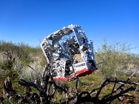
To tell you the truth, I was not really looking forward to it. If you read that link in the previous paragraph you will know why: In 2011, the entire area between Bob Bentley Trailhead and New River was riddled with garbage, particularly shotgun shells and various shot up home appliances. 😣
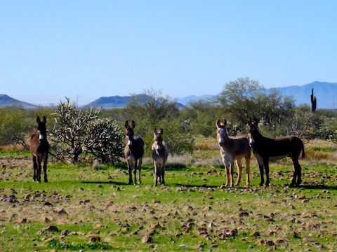
I hiking from the Emery Henderson Trailhead just after 9:00 a.m. Even though it was 41°, it was sunny, so it felt good with only a shirt on, no jacket. After playing “Frogger” across New River Rd., I headed south towards New River. I’ll skip telling you about my outbound hike, since I wandered down various jeep trails, so suffice to say that I could not cross New River dry (a rare event) and I crossed paths with a small herd of burros. Also, it was obvious that someone had done a huge cleanup all across Biscuit Flat, as I only spotted occasional shotgun shells.
There is no parking lot at Bob Bentley Trailhead, so either park on the side of Carefree Highway or just inside the gate. (If it is unlocked, which it probably is.) An obvious jeep trail heads northeast, but turn east along the less obvious jeep trail paralleling AZ-74. In 250 yds., at Deadman Wash, the jeep trail splits. Turn left along the more obvious of the two. (Or pick your way up the middle of the riparian area, looking for birds or flowers.)
In 1.3 miles, the Black Canyon Trail reaches some power lines. Turn straight north. You may hear quite a bit of shooting. Do not worry: That is the Ben Avery Range, a half mile east. As long as you stay on trail, you are perfectly safe. 🔫
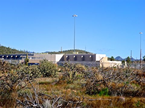
At 2.4 miles, the Maricopa Trail turns east. (The Maricopa Trail is a 315-mile loop trail around the entire Phoenix metro area.) Just ahead is a cluster of buildings surrounded by razor wire. That is Federal Correctional Institute Phoenix, aka Federal pound me in the ass prison. You may also hear shooting there, but it is another range, not a jail break.
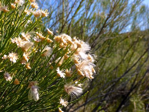
From FCI Phoenix the Black Canyon Trail turns from jeep trail to single track. There’s quite a few cholla, in a variety of species, saguaro are rare, and I only spotted one barrel cactus. There was plenty of green grass, and even some dense clusters of a leafy plant, due to the heavy winter monsoon. The burros were quite vocal about me interrupting their grassy meal. 🐴
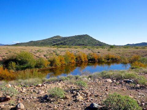
At 3.4 miles, the Black Canyon Trail crosses Desert Hills Dr., which is dirt & rarely travelled, unlike its paved version on the other side of I-17. Not much of the monsoon rain has evaporated, and there a number of large puddles in various jeep trails to either side of the BCT. The largest store of water I spotted was a ¼ mile north of Desert Hills Dr., a full tank spotted with fall color.
At 4.1 miles, just after cross dirt Rockaway Hills Rd., is New River. The rocky river bed is about 400 ft. across and 15 ft. deep. In 2011, between monsoons, it was bone dry. Today, mid-monsoon, it had flow 100 ft. wide and 4″ deep. In the morning, heading south, I tried to rock hop, but gave up after getting my feet wet. In the afternoon, on the way back north, I didn’t bother, and just splashed right across.
North of New River, the Black Canyon Trail switches from single track, to jeep trail, then back to single track. The remains of an old well — a circular concrete pad, and a busted up wood spring box — are at 4.7 miles. A ¼ mile further, on the west side of the trail, are some small buildings. That is the New River Transfer Station, where your garbage is temporarily dumped before being shuffled off to a proper landfill.
At 5.7 miles there is another dirt road, unnamed, and just ¾ miles past that, on the north side of New River Rd., the Emery Henderson Trailhead.
To summarize the southern most segment of the Black Canyon Trail: It’s not all that scenic, but it is a fair number of miles. The it would be a good place for easy horseback riding, or introductory mountain biking. (The BCT is a popular bikepacking route; that could be done end-to-end in a long weekend.) In other words, it’s miles.
Bob Bentley TH Directions: From Phoenix, head north on I-17 to Exit 223B, west onto AZ-74 / Carefree Highway. The Bob Bentley Trailhead is on the right, one mile past the stoplight at the Arizona Game & Fish complex. There’s lots of traffic on AZ-74 so, for security sake, I would drive through the gate and park behind some palo verde.
Emery Henderson TH Directions: From Phoenix, head north on I-17 to Exit 232, west onto New River Rd. The Emery Henderson Trailhead is on the right in 3.2 miles. There is no entry fee.
GPS File: BCT_Carefree_Hwy_to_New_River_Rd
Distance: 13.85 mi.
AEG: 375 ft.
Time: 4h 46m
Hike Video
Black Canyon Trail: Carefree Highway to New River Rd. from Preston McMurry on Vimeo.