

Brown’s Mountain is a formation in the McDowell Sonoran Preserve, north of the ritzy Troon North Golf Club. It is part of a chain of free-standing formations: Cone Mountain, Brown’s Mountain, Teddy Bear Ridge, Cholla Mountain and Granite Mountain. (Which is different from the famous Granite Mountain in Prescott.)
I hiked just east of Brown’s Mountain in March, 2020, around Granite Mountain and Cholla Mountain. Besides interesting rock formations, such as Balance Rock, that loop had amazing flowers: The brittlebush and chuparosa were off the charts! So, I figured I would hike in the same area, around the same time of year. 💡
But after the utter failure of my early March flower hunt at Picacho Peak and in the Phoenix Sonoran Preserve, I texted my mine exploring buddy Prescottstyle, and instead we summited Hyde Mountain. After returning from Easter in Maryland, bougainvillea were doing great in our neighborhood, so I decided to take a crack at another local flower hunt.
At 30,500 acres, Scottdale’s McDowell Sonoran Preserve is almost double the size of America’s next largest city park: Phoenix’s South Mountain Park. And those 30,500 acres do not include the 21,000 acres of adjacent McDowell Mountain Regional Park, which belongs to Maricopa County!
Because the McDowell Sonoran Preserve is so large, there’s a lot of trailheads. Park at an official trailhead to avoid parking tickets. I started from the Brown’s Ranch Trailhead, which has water, separate mens’ & womens’ toilets, a shaded rest area and several signs explaining the history of the area. 🤠
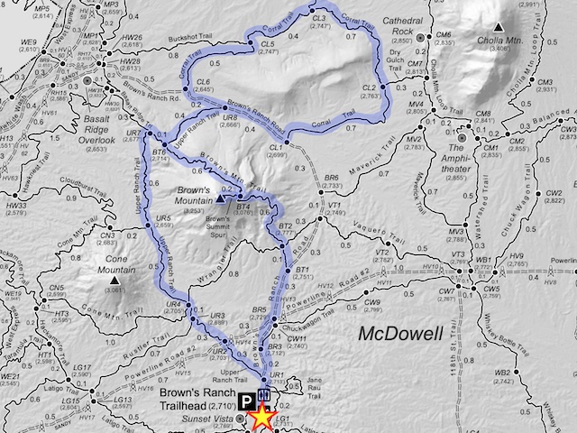
If you look closely at the above map, you will note that every official trail intersection is marked two letter trail abbreviation and a number. On the ground, there is a matching numbered sign giving direction and distance to the next trail. The marker number also serves as a useful locator, if you need to call in an emergency. (I did not check cell phone reception anywhere on my hike.)
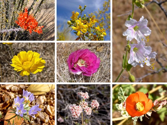
Middle Row: desert marigold, strawberry hedgehog.
Bottom Row: miniature woollystar, flat top buckwheat, desert globemallow.
Brown’s Ranch Trailhead was about half full when I started hiking at 8:45 a.m. Just gazing out at the McDowell Sonoran Preserve, I did not see any flowers, so my hopes were not high.
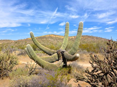
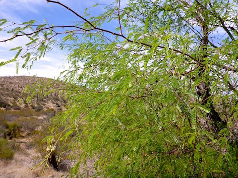
Upper Ranch Trail (UR) is 2.3 miles, with maybe 100 ft. accumulated elevation gain (AEG). Mostly due to wash crossings, without which the terrain surrounding Brown’s Mountain would be as flat as it looks. After a ⅓ of a mile, Upper Ranch Trail passes under power lines. That is when I started finding some small flowers here and there, most of which are in the above collage. The strawberry hedgehog mostly had flowers, but they were smaller, and not fully open. The ocotillo were outstanding. 👍
I passed by Brown’s Mountain Trail (BT6), then left onto Brown’s Ranch Road (UR8), before hiking Corral Trail clockwise from CL6, which is adjacent to a dry cattle tank built of cinder block. It was interesting to watch Brown’s Mountain change shape throughout the day, as I rotated around it.
Corral Trail (CL) is also 2.3 miles around Teddy Bear Ridge, but it has 40% more AEG than Upper Ranch Trail: A whole 140 ft.! So, also basically flat. Corral Trail has some nice views north to Cave Creek, but also travels through some lower areas, so there was more grass & shrubbery along it, particularly acacia, which as bright green as I’ve ever seen them. The creosote were still blooming. 🌿
There is little shade anywhere in the McDowell Sonoran Preserve, so I took advantage of what I could find for brief break in a wash at the east end of Teddy Bear Ridge. (Named for the many teddy bear cholla in the area.) After five minutes, I continued west on Cholla Trail towards Brown’s Ranch.
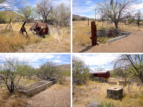
In the Brown’s Ranch area I found collapsed barbwire fence, an old feed hopper, a sunken foundation, another dry cinder block cattle tank, two dry cement spring boxes, and some other odds & ends. I somehow missed the ranch house remains, which are on the west side of Brown’s Ranch Road.
Brown’s Ranch Road (BR) is 1.8 miles, with 70 AEG. Just after I turned onto it for the second time (CL1), I got rattled for my first time this year, by a small, but very angry, western diamondback. Thankfully, we were on opposite sides of the road, about 10 ft. apart. I didn’t get closer, but when I crouched down to take a photo he quickly slithered along his side of the road in my direction. That got my attention! 😳
After the snake and I parted ways, I continued on Brown’s Ranch Road for a bit, before turning left back onto Upper Ranch Trail (UR8) for a short while. After several hours, I was finally starting to encounter mountain bikers and other hikers.
Brown’s Mountain Trail (BT) is 1.3 miles. North-to-south it is 350 AEG; south-to-north 300 AEG. Regardless of direction, it switchbacks up to a saddle (BT4) at the trail’s mid-point, which has some good sitting rocks. I found the best strawberry hedgehog of my hike on the way up.
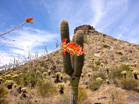
Brown’s Summit Spur (no code) is short, but steep — 180 AEG in only 250 yds. — and slippery with pea gravel over rock. The summit is larger than it looks from below, with plenty of good sitting rocks. Being free standing, Brown’s Mountain has 360° views. Four Peaks was obvious to the east, but the only mountains I took time to identify were to the south: East End Mountain, Tom’s Thumb, Troon Mountain and Pinnacle Peak.
After photos and a snack break, I headed carefully down the summit spur to the saddle, then continued south on Brown’s Mountain Trail. As I turned right onto Brown’s Ranch Road (BT1) for the third time, I was sideswiped by a mountain biker blasting along the road. Not a technical track: A flat road. What a hero. 🙄
After I finished my hike, I was going to stop at Mickey D’s for my traditional post hike lunch: Filet-O-Fish and large fries (extra salt), but I realized I was totally cashless, having donated my last $3 to the McDowell Sonoran Conservancy, who maintain the park. I call that a win.
Directions: From Loop 101 / Pima Freeway, take exit 36 north onto Pima Rd. for 6.7 miles. Turn right on Dynamite Blvd. for 2.9 miles. At the first traffic signal, turn left onto Alma School Rd., which passes by ritzy gated Troon communities, before dead ending 1.4 miles later at the Brown’s Ranch Trailhead. There is no entry fee.
Park Map: McDowell Sonoran Preserve North Area Map
GPS File: Browns_Mountain_Loop
Distance: 8.63 mi.
AEG: 861 ft.
Time: 3h 09m