

Due to lack of rain during the winter monsoon, this spring has been no super bloom. Rather the opposite. It wasn’t until last week at Brown’s Mountain, on my third flower hunt of the season, that I finally found any flowers at all!
I closely follow the Maricopa County rainfall data any time the clouds darken, and I’ve noticed that the heaviest rainfall is usually north of Phoenix, in the Black Canyon area. With an extra week’s warming, I headed up the Black Canyon Freeway to Bloody Basin Road and the ghost town of Cordes. 👻
Hiking from the large pullout a mile west of Cordes to the Big Bug Trailhead on Big Bug Creek, near Mayer, is the eleventh segment, south-to-north, of the Black Canyon Trail (BCT) Starting at 7:30 a.m., I knew I would finish the 7.7 mile segment well before noon, so after the hike I also planned to scout the next BCT segment, which doesn’t have the easy road access the first 66 miles do.
The Black Canyon Trail is for horses, mountain bikers, hikers and trail runners. Motorized vehicles are not allowed, but as elsewhere on the BCT, it is occasionally co-located a several jeep trail, such as BLM 9218A. (This segment is just east of the Prescott National Forest, on land managed by the Hassayampa Field Office of the Bureau of Land Management.)
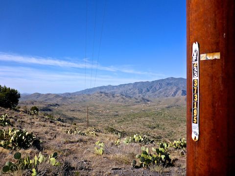
The Cordes to Big Bug Creek segment starts by backtracking east on Antelope Creek Rd. a ¼ mile to where it is crossed by the Black Canyon Trail. I turned left, onto a good quality unnumbered jeep trail. A ⅓ of a mile north on the BCT, a ragged old corral has great views of Black Canyon and the Bradshaw Mountains. 🏞
Because I was not expecting a lot of quality photo ops, the first couple of miles I was shooting stills and video, while trying think of some decent patter to dub over the video. To me, a video requires more time to convey the same amount of visual info as a still photo. So, I can keep my hike videos bite size, rather than rambling, disjointed and 90% unwatched like they were when I started in 2013.
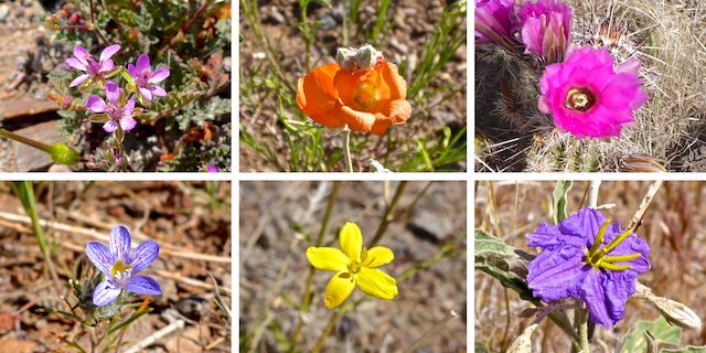
Top Row: redstem stork’s bill, desert globemallow, strawberry hedgehog.
Bottom Row: desert woollystar, rough menodora, silverleaf nightshade.
Don’t let that flower collage give you the wrong idea: I did not find many flowers. Redstem stork’s bill was by far the most common flower — easily over 90% of the blooms. Tiny ones, that were hard to photograph! I saw a few desert globemallow, but only those two blooms. Strawberry hedgehog were not frequent, but they were the second most common flower I found.
Desert woollystar looked like redstem stork’s bill, except blue, rather than violet; I only saw a few, north of Antelope Creek. I spotted a couple of rough menodora, just east of the Big Bug Trailhead. I saw two silverleaf nightshade: The first one by the dry corral above Dripping Springs canyon, which I forgot to photograph, and the above near Mayer, which I did not. 📸
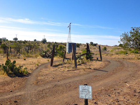
There is a trail a short way down to Dripping Spring, but to stay on schedule, I skipped checking it out. At the top of that small canyon is a corral with a broken Aermotor windmill. The jeep trail continues, but the Black Canyon Trail splits left onto singletrack foot trail.
Almost the entire Black Canyon Trail from Cordes to AZ-69 passes through rolling, juniper-dotted grassland. The only climb of any sort is 200 ft. in a mile, north from Dripping Spring corral. After the climb, the BCT descends the next ¾ through a beautiful little valley to Antelope Creek, which showed zero sign of recent water. The valley reminded me of California. The junipers provided enough shade that I took a break. 🌳
Antelope Creek is the halfway point of the Cordes to Mayer BCT segment. As the trail rises out of the creek bed, it passed through a dense field of dry, brown, fallow New Mexico thistle. It would have been spectacular if the thistle were blooming. A ½ mile from Antelope Creek, the Black Canyon Trail turns onto a jeep trail for the next ⅔ of a mile to Antelope Creek Rd.
After crossing Antelope Creek Rd., the BCT returns to singletrack for the final 2½ miles to Big Bug Trailhead. The trail curls around a small hill, then passes under powerline & phone lines, before crossing Big Bug Creek. On the north side of the creek, there is a buried pipeline and a mountain bike-optimized rollover gate. (I saw no MTBs, or hikers, all day.)
The final 1¾ mile to Big Bug Trailhead switchbacks on the contour line of a hill overlooking Spring Valley. (Much of the Black Canyon Trail is optimized for mountain bikes.) The BCT parallels Big Bug Creek and AZ-69 the final ½ mile to Big Bug Trailhead.
There were three cars at the Big Bug Trailhead, but they were all using the pit toilet as a rest stop, not for hiking. My wife was not among them. Somehow, she was 15 miles north in Dewey-Humboldt. But I was not angry, as without her loving help, I would not be able to do the hikes I do. 😘
After getting picked up by my wife, I did a scouting drive up Old Sycamore Road and AZ Hunt Club Road to see if the way was open to where the Black Canyon Trail crosses under the power lines over Brushy Wash. It’s seven miles north of Big Bug Trailhead, so that stretch would be another decent BCT segment. Unfortunately, two miles short of the BCT, the road was gated — with a keypad passcode! — private property. That’s a puzzle I’ll need to solve …
Antelope Creek Rd. TH Directions: From Phoenix, head north on I-17 to Exit 259. Head west on dirt Bloody Basin Rd. for three miles to the ghost town of Cordes. At the t-intersection, turn left on Antelope Creek Rd. In 1¼ miles, just after crossing the BCT, as the road begins descending into Black Canyon, turn left into the trailhead.
Big Bug Trailhead Directions: From Phoenix, head north on I-17 to Exit 262. There are two exit lanes, on the right hand side of the freeway: Be in the left one, which curls west to become AZ-69. Spring Valley is the little town on the left. 1½ miles past the high school football stadium, keep an eye out for a brown trailhead sign. At the median crossover, turn left into Big Bug Trailhead.
GPS File: BCT_Cordes_to_Big_Bug_Mayer
Distance: 8.33 mi.
AEG: 729 ft.
Time: 3h 02m
Hike Video
Black Canyon Trail: Cordes to Big Bug Creek from Preston McMurry on Vimeo.