

First off, just to be clear, this is the Granite Mountain in north Scottsdale’s McDowell Sonoran Preserve — not the Granite Mountain in Prescott, made famous when the hotshots lost their lives on Yarnell Hill. Arizona has many places which share the same name, such as Black Canyon: the one hosting the Black Canyon Trail, between Phoenix and Cordes Junction; the one below Liberty Bell Arch, on the Colorado River; and the one adjacent to the Big Stick Mine, north of Wickenburg. God knows, there’s probably others. 🙄
I thought Phoenix’s South Mountain Park (16,283 acres) was the largest city park in the United States, but actually it is Scottdale’s McDowell Sonoran Preserve (almost double the size at 30,500 acres). In fairness, South Mountain is constrained by the city on three sides, and the Gila River Indian Community on the fourth, while Scottsdale has been busy buying up old ranches in its northern hinterlands.
Because the McDowell Sonoran Preserve is so large, there’s a lot of trailheads. Park at an official trailhead to avoid parking tickets. I started from the Granite Mountain Trailhead on 136th St., two miles north of Rio Verde Dr. The trailhead has separate mens’ & womens’ toilets, a shaded rest area and several signs explaining the plants, animals & geology. Note: No water is available. 🚫🚰
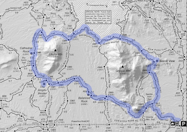
If you look closely at the above map, you will note that every official trail intersection is marked two letter trail abbreviation and a number. On the ground, there is a matching numbered sign giving direction and distance to the next trail. The marker number also serves as a useful locator, if you need to call in an emergency. (I did not check cell phone reception anywhere on my hike.)
Bootlegger Trail (BL) is 1.3 miles, climbing 170 ft. The grade is barely noticeable. Bootlegger is wide and smooth. While not wheelchair accessible, even someone with a zimmer frame could hike it. I hiked the whole thing from the trailhead to the intersection with Granite Moountain Loop Trail at trail marker GM4. The best close-up boulder photo ops are on Bootlegger, as well as some spectacularly prolific saguaro. 🌵
Granite Mountain Loop Trail (GM) is 4.2 miles around … Granite Mountain. I first hiked the northern segment between trail markers GM4 and GM7, which is 1.6 miles, climbing 180 ft. Though the trail narrowed, it was still a bit wider than single track, and remained immaculately groomed. Indeed, all the trails I hiked today had mild grades and smooth surfaces, which the many mountain bikers enjoyed. The scenic overlook at GM10 — oddly located between GM4 and GM5 — has views of Bartlett Lake, the Mazatzal Mountains, Fountain Hills, Four Peaks and points south.
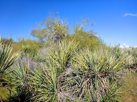
Branding Iron Trail is 0.8 miles, climbing a whopping 70 ft. Together with a short segment of The Divide Trail, it serves merely to connect Granite Mountain Loop Trail to Cholla Mountain Trail. If there were any flowers on Branding Iron, I didn’t notice them. There were, however lots of non-flowering banana yucca. (Indeed, I did not see a single cactus flower all day.)
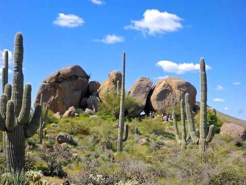
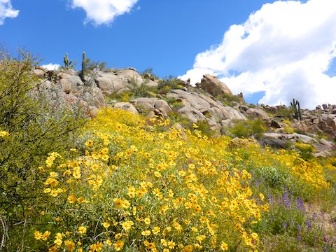
Cholla Mountain Loop Trail (CM) is a 3.1 mile loop around the Cholla Mountain. Of course. The two miles I hiked around its north, west and south flank, from CM4 to CM2, climbed 62 measly feet. Done clockwise, it would still climb only 200 ft. Cholla Mountain is where the flowers started getting really good, especially brittlebush and chuparosa. I took a break at Cathedral Rock, which looks nothing like a big old-timey church. Before Balanced Rock Trail, I stopped at The Amphitheater, which also looked nothing like an amphitheater. 🤔
Despite having a runny nose all day — due to allergies, not coronavirus! — my nose somehow managed to start bleeding quite profusely at The Amphitheater. Unbeknownst to me, I had shmeared the blood all over my lower face. I must have looked like the plague itself the remainder of my hike!
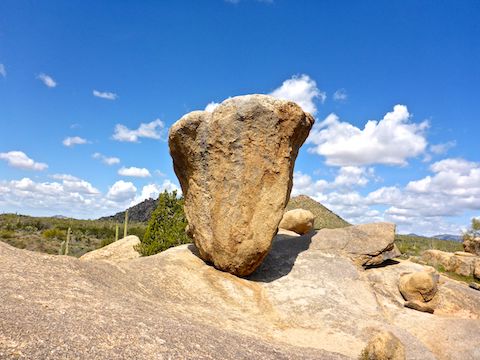
Balanced Rock Trail (RS) is 1.1 miles and flat as a board. Like Branding Iron Trail, Balanced Rock Trail was mostly banana yucca and shrubbery such as creosote. The highlight is Balanced Rock itself, which is a 25 ft. tall, cauliflower-shaped boulder, its narrow-end precariously balanced on a slight slope. The best view of Balanced Rock is on its east side, where I also found a particularly colorful patch of fairy duster flowers.
The south end of Granite Mountain Loop Trail, from GM9 to GM3, had — by far — the best flowers. The brittlebush and chuparosa were off the charts! Also great patches of lupine and owl clover. I saw one small cluster of flat top buckwheat and, a first for me, a small wirelettuce, which resembles desert chicory. 🌼🤗
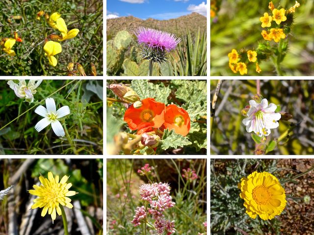
Middle Row: small wirelettuce, desert globemallow, desert wishbone bush.
Bottom Row: yellow salsify, flat top buckwheat, desert marigold.
I accidentally continued north on Granite Mountain Loop Trail from GM3 — which was the only slightly rocky trail surface I encountered — before doubling back to GM3, then turning down Saddlehorn Trail, which is less than a ¼ mile long. But Saddlehorn has a name, so there is that.
Saddlehorn Trail connects to Bootlegger Trail midway, at trail marker BL2. From there it was a quick 0.7 miles back to the Granite Mountain Trailhead, which was about half full, despite the coronavirus panic. Heart disease and obesity-related complications kill 20-25% of all Americans, over 640,000 in 2017 alone. So, yeah, I’m more concerned about my fat ass than a Wuhan Flu which has killed far fewer Americans than season flu over the past three months. 💔
Directions: From Loop 101 / Pima Freeway, take exit 36 north onto Pima Rd. Head north for 6.7 miles. Turn right on Dynamite Blvd., which in 3.0 miles becomes Rio Verde Dr. Continue straight through two traffic circles for another 3.0 miles to 136th St. Turn left. In 2.0 miles, the Granite Mountain Trailhead will be on your left. There is no entry fee.
Park Map: McDowell Sonoran Preserve North Area Map
GPS File: Granite_Mountain_Loop
Distance: 9.79 mi.
AEG: 736 ft.
Time: 3h 23m
Hiking Video
Flowers @ Granite Mountain, McDowell Sonoran Preserve from Preston McMurry on Vimeo.