

There’s a Table Mesa (“Table Table”) in Arizona, so why not a Picacho Peak (“Peak Peak”)? 😜
Picacho Peak is the distinct formation on the west side of I-10, in the empty quarter south of the Casa Grande “metroplex”. The Battle of Picacho Peak on April 15, 1862, is often erroneously cited as “the westernmost battle of the American Civil War”. The westernmost battle was actually the Battle of Stanwix Station, 110 miles further west, on March 30, 1862, after which the victorious California Column stopped at the hot springs of nearby Agua Caliente to recuperate.
Personally, after leaving Phoenix at 6:00 a.m., to avoid the worst rush hour traffic, we stopped for breakfast at the Cracker Barrel in Casa Grande. Not a luxurious hot spring, but it would do while waiting for sunrise.
My wife dropped me off at the Sunset Day Use Area, 200 yds. below Sunset Vista Trailhead, as the day use area has a pit toilet the trailhead lacks. (See park map, attached below.) There was another couple at the trailhead when I got there, so I let them get ahead of me while I occupied myself reading the Juan Bautista de Anza historical signs. I lack the shamelessness many do about waving their camera around in front of other people. 😊
Picacho Peak trails are normally quite crowded — especially Hunter Trail — but I started hiking at 9:00 a.m. and did not see anyone else until Sunset Vista Trail intersected Hunter Trail halfway up the mountain. Thursday must be a good day.
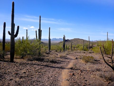
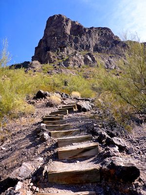
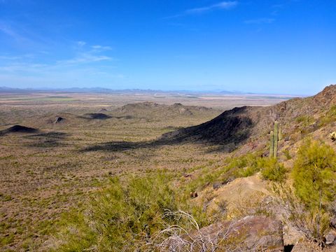
From the trailhead, Sunset Vista Trail drops crosses a wash, before following a fence line 200 yds. towards a small knoll, where I encountered the first of many stairs. These were relatively new, and wood, but some are stone or older, even falling apart.
Sunset Vista Trail climbs 200 ft. in the first ¼ mile, which while not long, nor extreme, is enough to get your heart immediately pumping. Looking at the topo, the trail would otherwise appear to be flat the first two miles, but it crosses many washes, giving the first two miles the official “moderate” rating.
Normally, the first week of March is Picacho Peak State Park’s peak flower season. The park’s last flower update was two weeks prior, and all they were reporting was scattered Mexican gold poppy. I was hoping a few weeks of increasing temperatures had brought out some lupine, or desert chicory, but no such luck. The flowerporn was distinctly G Rated: All I saw were a few scattered ocotillo blooms. 😕
On my way back along the first two miles of Sunset Vista Trail, around 11:30 a.m., there was regular foot traffic, including a few dogs. Picacho Peak State Park discourages taking dogs up the cabled sections: If you do, carry Fido in a backpack or harness, so you have your hands free.
At the two mile mark, Sunset Vista Trail crosses a wider, more gravelly, wash marked by three cairns. A number of larger palo verde provide wispy shade. The casual stroll is done: The climb begins.
From the three cairns, Sunset Vista Trail climbs 1260 ft. in just over ¾ of a mile. That’s the equivalent of 1575 ft. in a mile, which I would consider extreme. In mathematical terms, it is a 30% grade. But some sections are relatively “flat” (see above), while others are near vertical (see below). There are numerous switchbacks, and more stairs, the ½ mile above the three cairns. 😅
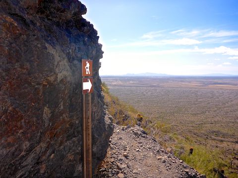
As Sunset Vista Trail is on the west and south side of Picacho Peak, there is little shade, especially in the first two miles. The only good shade is provided by a large boulder 2.2 miles into the hike.
The Sunset Vista Trail cables start at the 2.5 mile mark. At first it seemed as if they would be no big deal, but I was soon disabused of that notion: I saw this. 👇
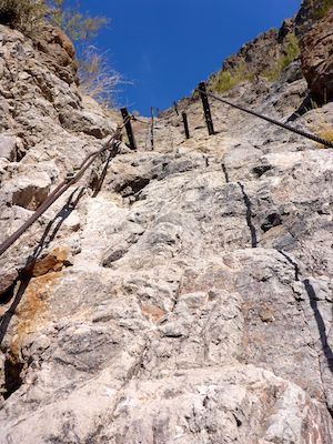
How the hell was I going to get up it? I took a few minutes to plot my route: Left foot in that crease, right foot on that pole, etc. to the top. Getting up is always the easy part: I also had to consider how to get back down. It wasn’t far, but it was steep, and falling would suck. I put a bottle of water in my front pocket (so it wouldn’t fall out) and dropped my pack, so my center of gravity would be more forward.
I seem to recall making it up a second cabled section before Sunset Vista Trail intersected Hunter Trail. Fifty yards past that was another vertical cable section, this time with side netting … in case you fall. I looked at it. Looked at my GPS. Looked at it again. At that point it was 500 ft. in only a ¼ mile to the summit. My main goal in hiking is exercise. I had done that. So, I bailed. ↩️
I went forward, butt scootching, back down the first Sunset Vista Trail cable section, so I could see where I was going and not have to feel with my feet for footholds. I actually wrapped my arm around the cable, using it as a brake, which is why the next few days it was my lats that were sore — and, for some reason, my abdominals? — rather than calves.
I guess that’s why Picacho Peak State Park recommends gloves, but a safety line and carabiner would not have been out of place.
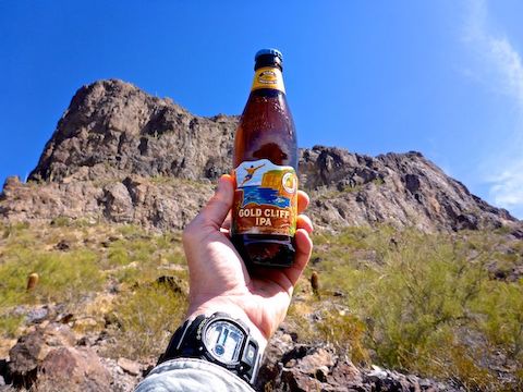
After I met back up with my wife at Sunset Vista Trailhead, we headed across I-10 to the Dairy Queen. (From what I gather on HikeArizona.com, it is tradition to have a cherry-dipped cone after hiking Picacho Peak.) I forgot to stop at the Battle of Picacho Peak memorial. 🪦
At the DQ, over lunch, rather than talk about my hike, I mostly listened to my wife talk about her visit to the nearby Rooster Cogburn Ostrich Ranch. Besides ostriches, they have rabbits, sheep, goats, cownose stingrays, and even some sort of parrot called a “lorikeet” — all of which you can feed. She’s wanted to see the ostriches for years, so she was happy. And a happy wife is a Very Good Thing.
Directions: From Phoenix, head south on I-10, past Casa Grande. Picacho Peak is the obvious, standalone mountain, ahead on the right. Just south of the pecan groves in Eloy, take exit 219. At the bottom of the ramp, turn right onto Picacho Peak Rd. The Picacho Peak State Park entrance is a ½ mile ahead. (Day use fee $7 / vehicle.) The Sunset Vista Trailhead is at the end of Picacho Peak Rd., two miles past the entrance.
Park Map: Picacho_Peak_State_Park_Trail_Map (pdf)
GPS File: Sunset_Trail_Picacho_Peak
Distance: 5.56 mi.
AEG: 1,395 ft.
Time: 2h 28m
Hiking Video
Picacho Peak: Sunset Vista Trail from Preston McMurry on Vimeo.