

After two weeks of minimal physical activity, including seven days sitting in my car, driving to & from Maryland, I needed to do some real physical exercise. Not just walking around my neighborhood, or to the post office. With November temperatures in the Phoenix area typically a moderate mid-70s, I figured it was time to start my winter routine of lower elevation locals hikes.
Since I hiked the Windgate Pass-Bell Pass Loop, in the McDowell Sonoran Preserve, around this time last year, I figured I would return to the area. My orginal idea was to hike up Thompson Peak, but I reconsidered after comparing my lack of recent climbing to a hike that has been described as “extremely steep” and “laughably steep”. ✋
The easy first 2.5 miles of the Thompson Peak climb are actually on Dixie Mine Trail, so I settled for doing that out to Dixie Mine, then looping around the hill that hosts the mine on Prospector Trail, Bell Pass Trail, Windmill Trail and Coachwhip Trail, ending with a short mine explore, before heading back to the Golden Eagle Trailhead.
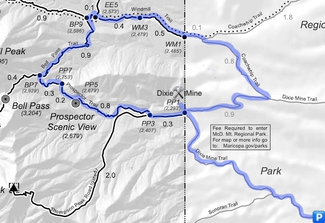
There are several shorter options to doing the full 10.7 mile, 1,400 AEG (accumulated elevation gain) Dixie Mine Loop:
- Dixie Mine Trail to Thompson Peak Rd.: An out & back to the service road is 5.0 miles, 450 AEG, with no obstacles or climbs.
- Prospector Scenic View: Out & back. Add 2.0 miles, 400 AEG, to option #1. No obstacles; moderate climb.
- Dixie Mine: Out & back. Add 0.8 miles, 130 AEG, to option #1. Minor obstacles; short climb.
- Prospector Scenic View & Dixie Mine: All the above are 7.8 miles, 980 AEG.
Golden Eagle Trailhead — as it is indicated at its map & info kiosk — is also known as Dixie Mine Trailhead and Eagles Nest Trailhead. It’s a very nice lot, just outside a gated luxury community where large hill-top villas are typically separated by 100 yds. or more. The trailhead has actual his & hers restrooms. A baby changing station filled with an adult volume of urine was the only sour note.
The Dixie Mine Loop starts by crossing Mountain Pkwy., just in front of the Eagles Nest gate. Turn left and — as the sign requests — stay on the sidewalk for the next half mile, following the eagle feather emblems in the pinkish concrete. Dream about hitting the PowerBall, so you too can afford one of the beautiful homes. 💰
In a ½ mile, cross the road, towards the fence marking the McDowell Mountain Regional Park boundary. There’s a pay station, where you slip $2 in an envelope. No one’s checking, but it helps pay for something you actually use & enjoy. (Unlike taxes.)
Dixie Mine Trail is decent, rolling, singletrack that crosses four minor washes while gaining only 200 ft. in 2.5 miles. Even though the sun had risen, starting at 7:40 a.m., the trail was still in full shade for 15 minutes. One hiker was already on their way back in, and I got passed by a couple of mountain bikes. Dixie Mine’s tailings pile is easily visible the final ½ mile.
Thompson Peak Rd.: When Dixie Mine Trail reaches the dirt road, turn left. (I suppose you could do the loop counter-clockwise, but I wanted to save the mine for last.) The signage will change, as you are now in McDowell Sonoran Preserve, which belongs to Scottsdale. (McDowell Mountain Regional Park belongs to Maricopa County.) I was actually passed by a work pickup, that took longer driving up to the antenna farm than I did hiking up to Prospector Scenic View. After a ¼ mile, turn right onto Prospector Trail.
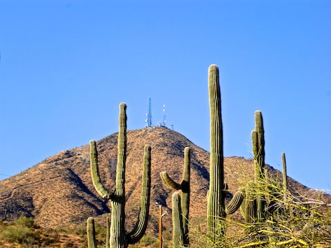
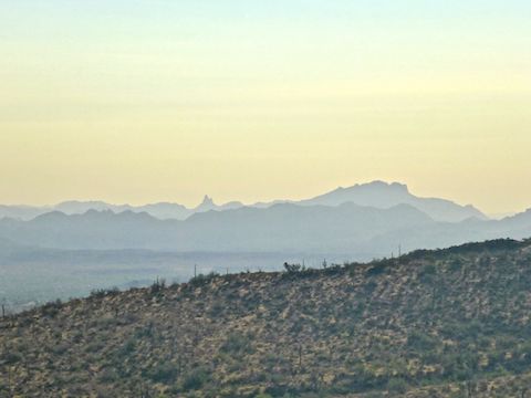
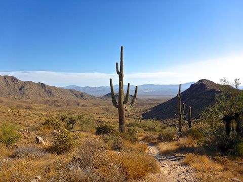
Prospector Trail: The only real climb of the day, Prospector Trail gains 500 ft. in 1.3 miles. There’s jumping cholla close to the trail, and I had to pick my way through a short section of trail scattered with pokey spike balls. Prospector Scenic View is located about halfway up; it has a good view of Thompson Peak, and decent views down the peak’s west drainage into Fountain Hills, and the Superstition Mountains in the distance. No shade or rest bench though. In fact, no shade anywhere on the Dixie Mine Loop, other than in the wash below Dixie Mine’s tailings pile.
Bell Pass Trail: Other than an occasional wash crossing, from the southeast slope of McDowell Peak, it is gradually downhill all the way back to Golden Eagle Trailhead. Bell Pass Trail descends 300 ft. in almost a mile to the intersection with Windgate Pass Trail / Windmill Trail. I passed two more hikers just before the intersection. Turn right onto Windmill Trail.
Windmill Trail: On satellite view, I had spotted a Whazzit? a ⅓ of a mile below Bell Pass Trail. Turns out it was a trail maintenance tool box, which I spotted several of in other locations last year. It never occured to me there might actually be a windmill along Windmill Trail, but there is: If you turn right into the wash just past the tool box, the windmill is about 200 yds. “downstream”. No idea what remains of it. Windmill Trail descends 150 ft. in a mile to Coachwhip Trail.
Coachwhip Trail: Back in McDowell Mountain Regional Park, turn right at the only rest bench of the day. The trail descends 150 ft. in just under a mile to Dixie Mine Trail. The McDowell Fire burned 615 acres just to the north of the Coachwhip Trail back in August. Since our summer monsoon was non-existent, I could still see some of the red retardant drops.
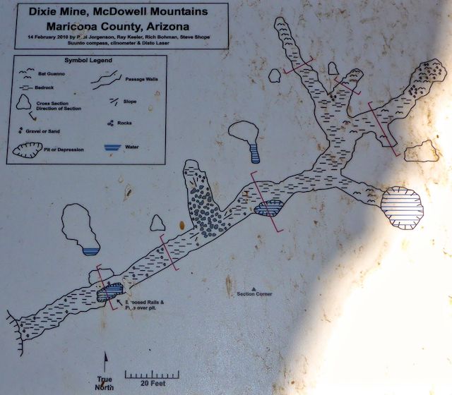
I turned right back onto Dixie Mine Trail, from which you can see the tailings pile most of the way. In ¾ of a mile, it rejoins Thompson Peak Rd. After just a few feet, turn right up a rough path. In 300 yds., you will be at the top of the Dixie Mine tailings pile. I found a few feet of wood oar cart tie and several small concrete foundations. The shaft was covered with both chicken wire and, atop that, a heavier, wider-spaced, rebar “net”. The rebar could handle human weight, and you won’t fall through the space, but I didn’t feel comfortable stepping into the middle, so I flattened myself and crawled out to take down-shaft video. There was water at the bottom. 📸
I waited for the famous Fountain Hills fountain to erupt at the top of the hour, but could not see it from the top of the mine. Instead, I headed down into the wash, where there are two adits: The smaller just “no trespassing” signed; the larger gated & locked. The highlight though, was the really cool mine diagram above.
After checking out Dixie Mine, I booked it back to the Golden Eagle Trailhead, whose baby changing station hadn’t been cleaned. After a swing by the Fountain Hills Mickey D’s for my standard post-hike Filet-o-Fish meal, with large fries, extra salt, I was back home by 2:30 p.m. And THAT is my favorite part of locals hikes: An early end to my day. 😁
Directions: From Loop 101 / Pima Freeway, head east on Shea Blvd. towards Fountain Hills. In 7.8 miles, turn left on Palisades Blvd. In 1.6 miles, turn left on Sunridge Dr. In 2.7 miles, turn left on Mountain Pkwy. / Golden Eagle Blvd. In 0.5 miles, just before the gated community, turn left into the Golden Eagle Trailhead. There is no fee for parking. The $2 trail fee is payable upon entering the park, after a ½ mile walk.
Park Map: McDowell Sonoran Preserve South Area Map
GPS File: Dixie_Mine_Loop
Distance: 11.65 mi.
AEG: 1,460 ft.
Time: 4h 21m
Hiking Video
Hiking Dixie Mine Loop, McDowell Mountains from Preston McMurry on Vimeo.