

Counter-clockwise from Bronco Trailhead, this is the 22nd segment of the Maricopa Trail.
The Maricopa Trail is a 315-mile trail system in & around the Phoenix, Arizona, metro area (aka The Valley of the Sun). The loop itself comprises 245 of the 315 miles.
Though not official, I’ve divided the Maricopa Trail into 25 segments, such that each is anchored on some sort of trailhead, which is important if you want to avoid being ticketed, or you want your shuttle driver to be able to pick you up at the end of your excursion. And you will want a shuttle driver. 😉
There are three ways you could hike this Maricopa Trail segment: 1) The official route is 11.13 miles, 2170 ft. AEG (accumulated elevation gain); 2) the East End Trail shortcut is 7.85 mi., 2600 AEG; 3) the Tom’s Thumb Trail shortcut is 7.43 mi., 2565 AEG. (I chose the latter.) No matter which option you choose, an out & back hike would be a long, physical, day. All three are in the GPS file attached below.
I wanted to avoid the official Maricopa Trail route, as I’d hiked all the component trails before, some multiple times: Windgate Pass Trail (2016 & 2019), Windmill Trail (2020), Marcus Landslide Trail and Rock Knob Trail (2021), and Pemberton Trail (2021 & 2022). The official route is a 1,300 ft. climb to Windgate Pass, miles of boring flats, then miles of slow climb to Tom’s Thumb Trailhead. 🥱
The first Maricopa Trail alternate also makes the full Windgate Pass climb. But, halfway down the far side, the alternate route turns north up East End Trail which is another 1,000 ft. climb. I’ve never been on East End Trail, but I wanted to avoid back-to-back climbs.
Instead, I hiked the Tom’s Thumb Trail alternate, whose elevation gain is one long, steady, climb to its high point near the Lookout Trail junction. As a bonus, Tom’s Thumb Trail has attractive boulder formations. After today, I consider myself to have done the full official Maricopa Trail route, even if not all at once.
As most Gateway Trailhead hikes do, this Maricopa Trail segment starts by heading across the short iron walkway onto Saguaro Trail. It’s an easy trail with has scads of people. In just under ½ mile, turn left onto Gateway Loop Trail.
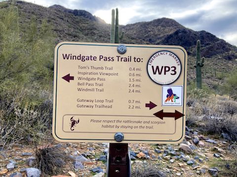
Though it has smooth spots, and occasionally drops 30 ft. here or there, Gateway Loop Trail climbs 360 rocky feet. At the 1⅔ mile mark, continue left onto Windgate Pass Trail. Most folks turn right to complete Gateway Loop Trail. Due to overcast, and the shadow cast by McDowell Peak, I was mostly in shade. It was quite chilly. 🥶
Windgate Pass Trail pitches up, climbing 400 ft. in the next mile. At least in winter, the main attraction is the many saguaro. It is not the slowly encroaching mega mansions of Silverleaf — including Arizona’s most expensive home — nor the non-existant desert flowers. (I didn’t see a single bloom all day.)
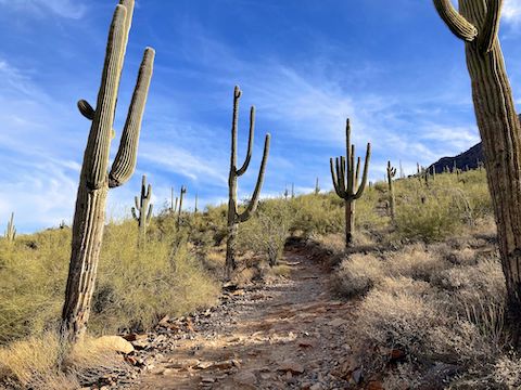
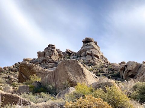
At the 2¾ mile mark, I turned left off the official Maricopa Trail, onto Tom’s Thumb Trail, which immediately drops 150 ft. in the next half mile to emergency marker TT15. (An unnamed use trail, which heads west towards the mega mansions.) Stay right, on Tom’s Thumb Trail, which follows the wash for another half mile, before beginning the climb in the above photo. 👆
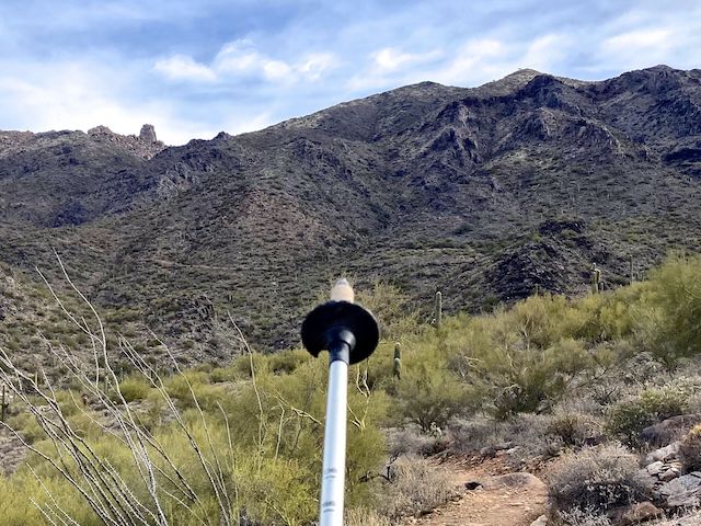
Each emergency marker number represents roughly a quarter mile. At marker TT13, there is a small oasis. A side trail leads up 200 yds. to Mountain Spring. A round trip from Gateway Trailhead to Mountain Spring, for a picnic, would be 7.5 mi., 1,500 AEG. Basically, TT13 is the halfway point of my Maricopa Trail alternate route.
Tom’s Thumb Trail continues its steady climb near the canyon bottom until TT 11, at the 4¼ mile mark. There, Tom’s Thumb Trail gets much steeper, switchbacking many times over the course of the next mile (and 780 AEG).
There is a colorful rock formation at TT9. It’s a flat, semi-open, area with at least one good sitting rock. I took a break to eat the half BLT I’d stuffed in a used coffee cup after the to-go container had burst (The Breakfast Joynt). Coffee cup worked perfect. Even room for some tater tots. Delicious!
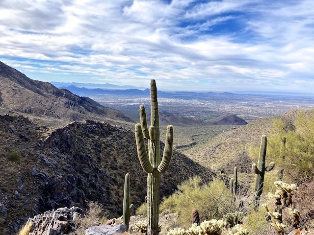
The switchbacks ended at 5 miles, Tom’s Thumb Trail reaching it’s high point a quarter mile later. At only 3,795 ft., the trail was a bit muddy, and there were small patches of icey snow. The high point is the Tom Thumb Trail’s closest approach to its namesake. If you want to add some views, and not much mileage, Lookout Trail is just ahead on the right and the base of Tom’s Thumb itself is on the left at TT7. 📸
The junction with East End Trail is just under 6 miles. After Tom’s Thumb Trail passes through a boulder field full of rock climbing locations such as “Glass Dome”, it begins descending in earnest, 900 ft. in just over a mile to Gateway Trailhead. From Tom’s Thumb on down, it is quite crowded.
I’ve now completed 210.85 miles of Maricopa Trail. Three more segments to go!
Gateway Trailhead: From Loop 101, take exit 36 onto Pima Rd. At the second light, turn right onto Legacy Blvd. In just over a mile, turn right onto Thompson Peak Pkwy. In a half mile, turn left into Gateway Trailhead.
Tom’s Thumb Trailhead: From Loop 101 / Pima Freeway, take exit 36 north onto Pima Rd. In 4.8 miles, turn right onto Happy Valley Rd. In 4.3 miles, turn right onto Ranch Gate Rd. In 1.3 miles, turn right onto 128th St. The Tom’s Thumb Trailhead is in 1.4 miles, just past the traffic circle.
Park Map: McDowell Sonoran Preserve trail map
GPS File: Maricopa_Trail_Gateway_TH_to_Toms_Thumb_TH
Distance: 7.74 mi.
AEG: 2,565 ft.
Time: 3h 30m
Rumble Video
Vimeo Video
Maricopa Trail: Gateway Trailhead to Tom’s Thumb Trailhead from Preston McMurry on Vimeo.