

McDowell Mountain Regional Park is a 21,099 acre Maricopa County park north of Fountain Hills and east of the McDowell Mountains. MMRP is immediately adjacent to the McDowell Sonoran Preserve, a 30,500 acre Scottsdale city park. Over 51,000 combined acres is a pretty darn big park!
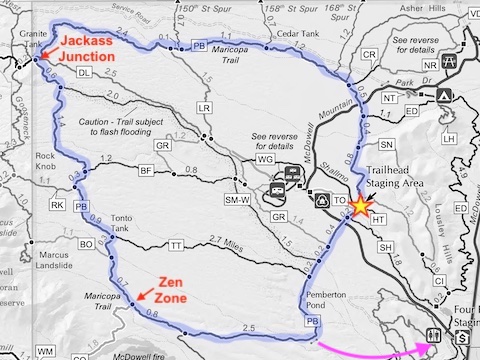
Pemberton Trail is a 15 mile loop around MMRP’s northeast corner. The Pemberton Trailhead, the usual start point, is in the middle of the eastern leg, which is basically flat. The northern leg rises a leisurely 500 ft. in five miles to Jackass Junction. The western leg is rolling, and sometimes rocky, but generally downhill. The southern leg is all downhill, but also occasionally rocky.
Pemberton Trail is a long, but easy hike. Today, though, I rode it on my mountain bike. Since I started riding again two months ago, I had mostly done shorter rides around North Mountain, so I wasn’t sure if I was ready for something longer. Nothing ventured, nothing gained. 💪
I never leave the middle chain ring on my 24-speed Trek. I started in 12th gear, (4 on my right shifter), but that was a bit too much, so I settled into 11th gear. I was aware of Pemberton Trail’s popularity, and my own limitations, so I was keeping my head up, while I headed north from Pemberton Trailhead.
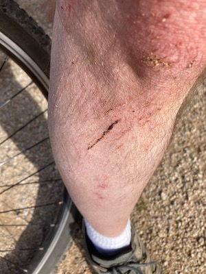
Maybe a mile in, I must have glanced down for a split second, because all of a sudden there was another bike coming towards me. I panic-braked, lost my rear end, and down I went. Bounced right up, apologized to the other guy, and continued on. 😊
After 1½ miles, Pemberton Trail crosses McDowell Mountain Park Dr., turns west and begins climbing. Every couple of hundred yards there’s a quick up & down wash crossing, but otherwise the trail climbs a steady 120 ft. per mile for the next five miles to Jackass Junction.
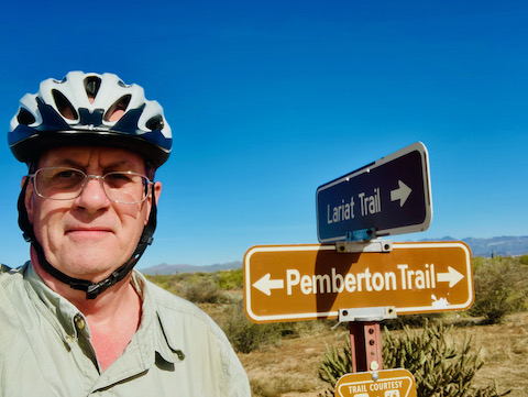
If you think of Pemberton Trail as a wheel, there are a number of trails that are spokes: Lariat Trail, Delsie Trail, Stoneman Wash Trail, Bluff Trail and Tonto Tank Trail. Heading back to Pemberton Trailhead via the spokes can save you a few miles. Riding counter-clockwise, as I was, Lariat Trail is just over four miles out, and saves 6½ miles. The other spokes save no more than 2½ miles. I was feeling good, so I continued. 👍
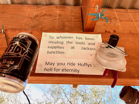
Jackass Junction is one of two rest / repair stops on Pemberton Trail. There’s a shelter, map board, tire pump, basic bike tools, and some humorous knickknacks. There’s a steep little climb south from Jackass Junction, so I walked my bike up, then rode it two miles to the Rock Knobb Trail junction. As I discovered on my Marcus Landslide hike, the descent from the junction is rocky, so I walked my bike down.
From there, I zipped along 1¾ miles to The Zen Zone stop, at the Coachwhip Trail junction. While I was literally just standing there, my tire suddenly, loudly, went PSSSSSH!!! I jumped, because I thought it was a snake. I checked my tire, tread and both sides, but saw nothing. I tried pumping it, but it would not hold pressure. Must be a broken stem. Somehow. Two-thirds of the way into the Pemberton Trail, and I gotta walk it the final five miles. 🤦🏻♂️
I trudged east on Pemberton Trail for a little over two miles. I had enough water to bike the full loop, but had to ration for hiking. At a dirt road junction, I looked at my GPS, spotting a road under ¼ mile to my right. Great! I’ll go down there, drop my bike, walk back to Pemberton Trailhead, then drive back to pick up my bike. Except the jeep trail kept bending away from the road.
At the junction of McDowell Competitive Track, I bumped into another bike. Nice guy from Colorado. He showed me his more accurate GPS map, and recommended I head for the Competitive trailhead instead. Being trail meant for MTB racing, the track was narrower, and much more up and down. Made my right arm sore.
Approaching the McDowell Competitive Track trailhead — or near the start of the race for bikes heading in the correct direction — is the Big Boss Drop. It is extremely steep, with pea gravel over granite. I tried pushing my bike up it, but actually slipped backwards. I resorted to going off trail, where I could find grip.
At the Competitive trailhead, I approached the first person I saw, asking if I could get a ride over to my SUV at the Pemberton Trailhead. No problemo! Another nice guy from Colorado.
Looking back on the day, I biked 10 miles and pushed my bike for 5 miles. I’ve quadruple-checked my data, and pushing my bike for 1h 37m, I somehow averaged an unblievable 3.2 mph! 😲
Directions: From Phoenix, drive east on Shea Blvd. Just over the top of the hill into Fountain Hills, turn left onto Fountain Hills Blvd. Stay on the road 3.9 miles through Fountain Hills. Beware the 15 mph school zone on the edge of town. Just past the school, the same road becomes McDowell Mountain Rd. In 3.6 miles, turn left on McDowell Mountain Park Dr. Entrance fee is $7. Stay on the road as it curves past the nature center. In 3.1 miles, turn right onto Shallmo Dr. Trailhead Staging Area is at the end of the road in 0.8 miles.
Park Map: McDowell_Mountain_Regional_Park_Trail_Map
GPS File: Pemberton_Trail
Distance: 16.17 miles
AEG: 920 ft.
Time: 3h 27m