

I spend the middle months of the year hiking in higher, somewhat cooler, locations, often involving long drives. Because, other than the Sky Islands, like Mount Graham, southern Arizona is a desert. Shocking, I know.
But from November to March, I go mine exploring, or do locals hikes. ⚒️
I had planned to explore the Ray Silver Lead Mine in the Dripping Spring Mountains this week, but Arizona got absolutely hammered with rain for three days — over 4″ in spots! — and I did not relish driving eight miles on muddy dirt roads. (The last time I tried that in my stock SUV, with street tires, did not go so well …)
So, I switched plans, moving up my McDowell Mountains hike, and the Ray Silver Lead Mine explore back to mid-December.
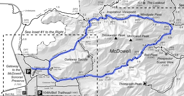
The hike I choose was the Windgate Pass – Bell Pass Loop, which starts from the Gateway Trailhead and includes several miles of the Gateway Loop Trail.
The incline on the west side of Bell Pass is steep, 900 ft. in a mile. I chose to do the loop clockwise so I would be doing the steep part downhill, rather than climbing it. Windgate Pass is nearly the same elevation as Bell Pass, but the climb to Windgate Pass is steadily moderate: 300 ft. each of the first two miles, 400 ft. the third mile, and 300 ft. the final ¾ mile. Overall, the Windgate Pass – Bell Pass Loop is 10.2 miles and 2,100 AEG (accumulated elevation gain). 😅
The massive Gateway Trailhead was not full, but even at 10:00 a.m. on a Friday there were plenty of people out exercising, not all of them over 65. There were enough people that I felt self-concious whenever I would film a segment for my hike video.

Saguaro Trail is a smooth, wide, 0.4 mile trail that connects Gateway Trailhead to Gateway Loop Trail. The handicap-accesssible 0.4 mile Bajada Trail is just over a short pedestrian bridge from the trailhead. The easy rated 0.3 mile Saguaro Loop Trail is located at the Gateway Loop Trail intersection, for those who want shorter, less strenuous options.
Gateway Loop Trail is a moderately strenuous trail that is 3.6 miles with 625 AEG, of which the Windgate Pass – Bell Pass Loop omits the middle third, over Gateway Saddle.
Windgate Pass Trail starts where Gateway Loop Trail turns south towards the Gateway Saddle, heading east over the pass, until it ends 3.1 miles and 850 AEG later at East End Trail. The Desert Park Trail, which runs through tony D.C. Ranch, and the Tom’s Thumb Trail, connect to Windgate Pass Trail along the way, the latter just below Inspiration Point. An out & back hike to Inspiration Point is a good shorter option at 6.0 miles round trip, and 1,100 AEG.
Bell Pass Trail heads west from the intersection of Windgate Pass Trail and East End Trail, ending 3.2 miles and 600 AEG later at Gateway Loop Trail.

The Windgate Pass – Bell Pass Loop is a typical Phoenix locals hike: There were a ton of people and lots of chatter on the Saguaro Trail and even on the first third of Gateway Loop Trail. I don’t recall any unleashed dogs, or “forgotten” dog crap, bagged or otherwise. There’s always at least one person wearing WAY too much perfume and today, surprisingly, it was a man. A middle-aged one at that. 😏
Every trail intersection is signed, with distance, direction and even an emergency marker — i.e., “BP7” — you can call in if some sort of disaster has occured, like somehow getting lost despite all the signs. I thought it ironic some of the signs asked hikers to stay on trail to respect the habitat of snakes & scorpions: It would have been nice if the scorpion that stung me three times on my couch had returned the courtesy. 🦂
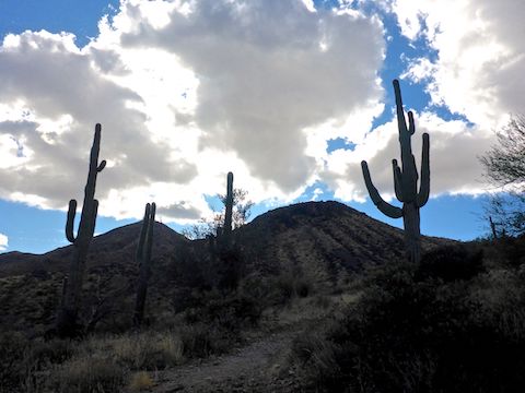
Between Tom’s Thumb Trail and Inspiration Point, what may have once been a ~10 ft. tall saguaro lay across Windgate Pass Trail in three large pieces, like a snapped pencil. The damage looked fresh. I did not see any signs of shooting, skin damage from a chain or rope, or other vandalism that may have caused the saguaro to break apart. Curious.

East from Windgate Pass, I could see Ft. McDowell and even Weaver’s Needle. Four Peaks was obscured by clouds. 🌁
After lunch — gas station murderwich and a beer — at the intersection of Windgate Pass Trail and East End Trail, I turned southwest up Bell Pass Trail. It was not a bad climb, but I was feeling the lack of elevation gain over the past few weeks. (Hiking 18 miles from Great Falls to Edwards Ferry on the C&O Canal had half the gain.)
Bell Pass had great views west towards Phoenix. I could easily pick out Papago Buttes, Camelback Mountain, Mummy Mountain, Piestewa Peak, North Mountain and Shaw Butte. 📸
From Bell Pass, it was all downhill back to the Gateway Trailhead, where I arrived feeling not too bad. (Though I was pretty sore the next two days.)
Directions: From Loop 101 / Pima Freeway, take exit 36 north onto Pima Rd. Turn right at the first light, onto Legacy Blvd. In 1.2 miles, turn right onto Thompson Peak Parkway. In 0.6 miles, turn left into the Gateway Trailhead. There is no entry fee.
Park Map: McDowell Sonoran Preserve South Area Map
GPS File: Windgate_Pass_Bell_Pass_Loop
Distance: 10.22 mi.
AEG: 2,097 ft.
Time: 4h 21m
Hiking Video
Hiking Windgate Pass & Bell Pass from Preston McMurry on Vimeo.