

Marcus Landslide was “discovered” in 2002 by two ASU geography post-grads. Surely, many people had looked at the rocks before, but the students were the first to realize what the rocks meant: That half the summit of East End had let go. The students named the landslide after their professor, Dr. Melvin G. Marcus. I know this because of the many, many, interpretive signs along the Marcus Landslide Trail.
Marcus Landslide Trail is only 4.0 miles, 600 ft. accumulated elevation gain (AEG), out & back, from the Tom’s Thumb trailhead. Other than a short 200 ft. climb up into the slidemass, the AEG is barely noticeable. Marcus Landslide Trail is wide and immaculately groomed. Easy even for older folks, or as an educational excursion for children. But I needed more. 🙂
To justify the hour-long drive to north Scottsdale, I planned to also hike the Rock Knob Trail, part of the Pemberton Trail, and the Boulder Trail, for an extra 2½ miles.
There were quite a few cars at the Tom’s Thumb Trailhead, but foot traffic was pleasantly light all day. Maybe because it was Christmas week. It was snowing in northern Arizona, with heavy rain predicted in central Arizona. (Christmas Eve saw 1.2″ at my home in Sunnyslope, and over 3″ in Crown King and at Mount Ord.)
When I started hiking at 10:00 a.m., it was cloudy, so I hiked clockwise. I figured saving Marcus Landslide for last, would give the sun time to break out. ⛅️
Rock Knob Trail is a mile from Marcus Landslide Trail, 260 ft. downhill past Rock Knob, east to the Pemberton Trail’s high point. Rock Knob is a small hill festooned with boulders and surrounded by plenty of cholla. But Rock Knob Trail is wide enough that I only spotted one mid-trail cholla ball. Otherwise, it is smooth & well-groomed.
Rock Knob Trail would be fun to blast down on a mountain bike. I spotted the remains of a metal tank under a large mesquite. Just past the mesquite, is the easily avoided half-fenced gate that marks the boundary of McDowell Mountain Regional Park. The Killen Bench is just before Pemberton Trail.
Pemberton Trail is a mostly mellow 15 mile, 850 AEG loop in McDowell Mountain Regional Park. Until today, I’d never been on Pemberton Trail, but my impression is it is similar in length, and relative ease, to the Butterfield-Pedersen-Coldwater Loop in the Estrella Mountains.
I hiked on south Pemberton Trail for only 1¼ miles, 150 ft. downhill. The first ¼ mile was rocky, but not a problem for hiking. I could see the Fountain Hills’ famous fountain erupting seven miles away. The Kilgariff Bench next to dry Tonto Tank, at the intersection with with its eponymous trail. Boulder Trail is ⅓ mile past the bench.
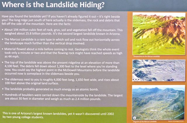
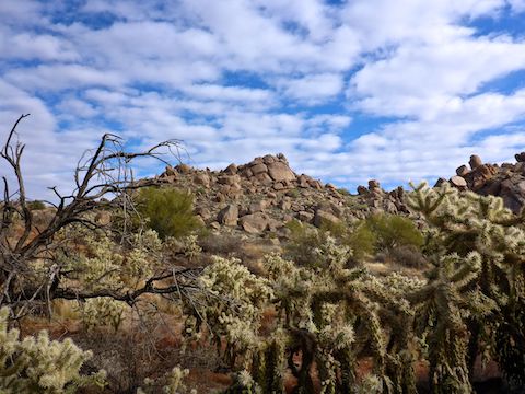
Boulder Trail climbs 260 ft. in a hair over a mile, to Marcus Landslide Trail. The vegetation was scrubbier than on Pemberton Trail, with at least one acacia providing shade, in an otherwise mostly exposed loop. The slidemass — explained in the above image — was visible as a long 30 ft. high mound to my left.
I was hoping there was a bench on Boulder Trail, so I could stop for a water swap & snack, but no such luck. I settled for plopping down on the ground. I was thirstier than would be expected for the moderate temperature. Humidity must have been low, despite the looming storm. 🥤
I actually took the time to read all the interpretive signs I encountered, including at the junction of Boulder Trail and Marcus Landslide Trail. Right is back to Tom’s Thumb Trailhead; left is the Marcus Landslide Loop. Don’t skip it! The loop is the highlight of this hike.
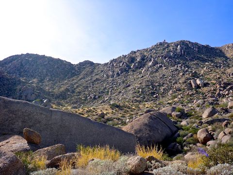
There’s a large boulder on the left, about halfway up the Marcus Landslide Loop. But it was a mere pebble to Submarine Rock, at the “far” end of the loop. There’s a number of Interpretive Points, which are 50 yd. diversions off the main loop. The first of these gave a good downslope view of the slidemass, which flowed a mile east.
After marvelling at the shear size of Submarine Rock, I stopped for a second break. I could see Weavers Needle, Four Peaks, Mount Ord and, closer by, Granite Mountain and Brown’s Mountain. I sure could have used more substantial hiking food than gorp. At least a murderwich from the Stop’n’Rob. ⛽️🥪
After enjoying Marcus Landslide Loop, I booked it back to the Tom’s Thumb Trailhead, only briefly pausing to check out a few more mushroom rocks, including Fallen Mushroom. (Where the top-heavy shroomy part finally separated from its base.) Merry Christmas & Happy New Year’s!
Directions: From Loop 101 / Pima Freeway, take exit 36 north onto Pima Rd. In 4.8 miles, turn right onto Happy Valley Rd. In 4.3 miles, turn right onto Ranch Gate Rd. In 1.3 miles, turn right onto 128th St. The Tom’s Thumb Trailhead is in 1.4 miles, just past the traffic circle. There is no entry fee.
Park Map: McDowell Sonoran Preserve trail map
GPS File: Marcus_Landslide
Distance: 7.21 mi.
AEG: 832 ft.
Time: 2h 32m
Hiking Video
Marcus Landslide Trail, McDowell Sonoran Preserve from Preston McMurry on Vimeo.