
 along Bajada Trail.")
Counter-clockwise from Bronco Trailhead, this is the 14th segment of the Maricopa Trail.
The Maricopa Trail is a 315-mile trail system in & around the Phoenix, Arizona, metro area (aka The Valley of the Sun). The loop itself comprises 245 of the 315 miles. Many miles of the Maricopa Trail are canals, sidewalks, and similar monotonous terrain. (Tres Rios Wetlands were interesting, but not challenging.) 🦆
Today’s segment in South Mountain Park, from the Bajada Trailhead, on San Juan Rd., to Telegraph Pass is a short 6 miles, but with a decent punch, at over 1,700 ft. AEG (accumulated elevation gain). There’s also some views and, for being in the city, it is relatively remote. The last segment with any significant AEG was the first one, from Bronco Trailhead to Spur Cross (1,800 AEG).
Because I was not hiking on the first full weekend of the month, when San Juan Rd. is open, I first hiked Bajada Trail 2¾ miles from the parking triangle to Bajada Trailhead. Since this blog is about the Maricopa Trail, I won’t describe Bajada Trail for you other than to say it crosses a lot of washes, and is easier heading west (generally downhill) than east.
If you don’t have someone to shuttle drive for you, you could make a loop of the 14th Maricopa Trail segment, Kiwanis Trail, Los Lomitas Trail, Derby Loop Trail, Max Delta Trail and Bajada Trail. From any point on that loop, the counter-clockwise stats are 11½ miles, 2,100 AEG. See the Park Map below. 🗺
From Bajada Trailhead, head west on San Juan Rd. for about a hundred yards to the crosswalk. Turn southwest onto National Trail, which is colocated with the Maricopa Trail for 15 miles from San Juan Lookout to Pima Canyon Trailhead. (And according to stickers on the many signposts, apparently the Sun Circle Trail as well.)

National Trail makes a small climb to a low saddle overlooking a canyon I explored many times while doing my Loop 202 South Mountain Freeway survey hikes, between 2015-2019. It was the only area I heard freeway noise. Occasionally a jet on approach to Sky Harbor would fly over and, later near Goat Hill, shooting at the Phoenix PD academy is audible. Otherwise, it was quiet.
The trail splits at the top of the low saddle: Gila Trail right, towards Graffiti Ranch; National Trail left, to the east. The signs along National Trail are often, but not always, marked with a white “N” on purple sticker. The sticker has latitude / longitude, distance, elevation profile, directional arrow and QR code. Some of the posts are barren. 🤔
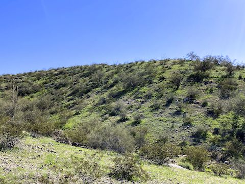
I remember the 14th Maricopa Trail segment as being a series of steep 250 ft. climbs, with short level respites in between. But the elevation profile in the GPS route attached below, shows it as one long two mile climb. The steepest part is the first mile after the short saddle, 650 ft. in a mile. Even at midday, there was spot shade in the unnamed east-west canyon.
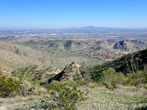
After the climb, National Trail generally follows the military crest of the Gila Range and Guadelupe Range. (Telegraph Pass separates the two ranges.) That is, National Trail does not go right over the tops of the ranges’ hills, but rather winds to the south or north of each rise, alternating views north across Phoenix with views south across Ahwatukee and the Gila River Indian Reservation.
There’s at least six prospects / collapsed mines along National Trail, only one of which is penetrable, and then only for about 20 ft. Take care near the mines, as none have safety covers or fences. I skipped right by them as my mine exploring days are over. ⚒️
Bursera Trail, Lost Ranch Ruins Trail, Lost Ranch Mine Trail, Pyramid Trail and Ranger Trail all intersect the 14th Maricopa Trail segment. For some reason only Ranger Trail descends to South Mountain Park’s inner valley. The others all descend south to Ahwatukee. The only hiker I saw before Telegraph Pass was on Lost Ranch Mine Trail. I saw no mountain bikes on National Trail: That would be a tough ride.
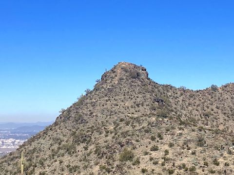
As I have on every other previous occasion, I walked right past the Goat Hill summit trail. (It’s a bit hidden behind a palo verde.) The trail switchbacks up for about 80 ft., then straight up another 30 ft. of Class 2 climbing, i.e. “possibility of occasional use of the hands”. Goat Hill, the high point in the Gila Range has sweeping 360° views from as near as Maricopa Peak to as far as the Bradshaw Mountains.
I could have used my hiking poles on the climbs, but I was glad to be carrying a Camelbak in lieu of my full pack. Especially over the seemingly endless final two Maricopa Trail miles to Telegraph Pass. I’m still working my way back into post-illness shape. Plus, I was getting hotspots or blisters on my right foot.
After enjoying the shade at National Trail Lookout, I descended the final 200 rocky feet to the Telegraph Pass pullout, where my patient, shuttle-driving, wife was waiting for me. The previous six miles of the Maricopa Trail were decent tread, but those final switchbacks definitely require attention to avoid ankle snapping. I’ve now completed 133.55 miles of the Maricopa Trail.
Bajada Trailhead Directions: From Phoenix, head south on Central Ave. until it enters South Mountain Park. Mind your speed, as there is a lot of bicycle traffic on the narrow road, and hikers crossing it. In 2½ miles, Telegraph Pass Rd. curls up to the left. Park in the triangle at that intersection. Or, if it is the first full weekend of the month, continue driving west on San Juan Rd. for a 2⅓ miles to Bajada Trailhead. (Cars are not allowed on the other days of the month.)
Telegraph Pass Directions: From the San Juan Rd. triangle, split left up Telegraph Pass Rd. for 1¾ more twisty miles to Telegraph Pass. There is a paved pullout with room for about four vehicles on the left / downhill / opposite side of the road.
Park Map: South_Mountain_Park_Trail_Map (pdf)
GPS File: Maricopa_Trail_Bajada_TH_to_Telegraph_Pass
Distance: 9.30 mi.
AEG: 1,800 ft.
Time: 3h 39m
Biking Video
Hiking Maricopa Trail: Bajada to Telegraph Pass from Preston McMurry on Vimeo.