

Counter-clockwise from Bronco Trailhead, this is the 12th segment of the Maricopa Trail.
Despite hitting 1,000 combined hiking & biking miles for 2022, I slacked off through much of December. Day after Christmas, I got sick. Not Chinese Lung AIDs, but the same congestion & cough all night thing I used to get every winter until some guy in Wuhan decided Peking Bat sounded delicious. (Ironically, I was not sick a single day during the three COVID winters.) 🦠
I delayed hiking the Maricopa Trail for a week, but want to complete it before the end of the year. So, despite only three or four hours of “sleep”, today I hiked from Phoenix International Raceway (PIR) to Tres Rios Wetlands, completing 117.31 miles of the 245 mile loop around metro Phoenix.
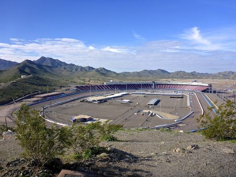
Normally, this segment of the Maricopa Trail starts behind PIR, at the Estrella Mountain Regional Park competitive mountain bike track. Two weeks ago, Avenida Estrella — the public right-of-way across private PIR property — was open. Today, the gate was locked. There was no event at PIR, so no idea why. The prospect of hiking 1¼ miles across PIR’s parking lot didn’t thrill me, so I shrugged my shoulders, and instead started at the Monument Hill Trailhead.
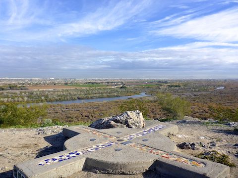
During PIR race weekends, spectators are seated on the west side of Monument Hill, which once marked the boundary between Mexico and the United States. Since the 1857, just after the Gadsden Purchase, Monument Hill has served as Arizona’s initial point (the “center” of the state’s surveying grid). The east side is fenced off by the Gila River Indian Community. 🚫
It doesn’t look like much, but Monument Hill is a steep little climb. Gravelly too. Mind your footing. Despite barely over 200 ft. of prominence, the summit of Monument Hill has great views due to miles & miles of flat surrounding terrain.
From the Estrella Mountain Regional Park trailhead, it is 5⅓ miles to the Tres Rios Wetlands trailhead on 91st Ave. Unless you cilmb Monument Hill, accumulated elevation gain (AEG) is negligible. From the Monument Hill Trailhead it is 3¾ miles. Because I wander about taking photos, my mileage was considerably more. 😏
Monument Hill Trailhead is just beyond PIR’s infield access. At the north end of the trailhead, an orange swirly metal Tres Rios sign indicates the area beyond vehicle gate is the Base & Meridian (B&M) Wildlife Area, operated by the Arizona Game & Fish Department. Unless you are a Maricopa Trail completist, start hiking here.
If you are a birder, not a hiker, my recommendation is either 1) walk ¼ mile north to the “island” between the Gila River and Salt River, then wander ½ mile out to the east tip of the “island”, or 2) starting at 91st Ave. head west 2¼ miles along the Maricopa Trail, North Overbank Wetlands Trail or South Overbank Wetlands Trail. All three are appropriate for small children, oldsters, and even wheelchairs (map).
Bird species in the Base & Meridian (B&M) Wildlife Area and Tres Rios Wetlands include Albert’s Towhee, mourning & white-winged doves, yellow & Lucy’s warblers, gallinules, Yuma Ridgway’s rail, Albert’s towhee, verdin, bald eagle and great blue heron. I saw coots, a great egret and what may have been a dark-morph Ferruginous hawk — all too far away for my Panasonic DMC-TS5 pocket camera. 📸
After ½ mile, the Maricopa Trail turns east at the north levee, which it more or less follows for another mile to the west end of the Tres Rios Wetlands. There’s scattered garbage, and not too much to recommend. It would have been nice if the powers that be routed the Maricopa Trail across one of the old jeep trails closer to the Salt River. (All distances measure from Monument Hill Trailhead.)
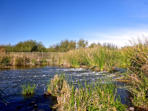
Flora includes Freemont’s cottonwood, Gooding’s willow, saltbush, cattail, bulrush, giant & alkali sacaton grasses, desert screwbean, mesquite, the usual array of Sonoran desert shrubbery, fan palm, and salt cedar — which might be invasive, but currently are a pleasant fall color. Plus several species of ground-hugging ferns / vines I can’t determine. I don’t remember any cactus, though I am sure they were there.
Upon entering the Tres Rios Wetlands at 1½ miles, there is a split / X-intersection: Maricopa Trail is straight, North Overbank Wetlands Trail left, South Overbank Wetlands Trail right. I went straight, and the path could not have been wider and smoother. Though vehicle access is blocked at either end, I did see an official vehicle go by. The main channel of the Salt River is out of sight, to the south.
Close by to the north of the Maricopa Trail, for the next 1½ miles, is a series of a dozen small ponds formed by cement check dams at their west end. Though surely a coincidence, the ponds alternate between open water and being covered by pennywort (small “lilypads”). The Maricopa Trail and various Tres Rios Trails all intersect at the Salt River Discharge Structure — which was loudly gushing water. 💦
There are 9 or 10 nature signs in the ¾ miles between the Salt River Discharge Structure and 91st Ave. trailhead. I was hoping to explore the islands north of the trailhead, but is fenced off and official use only. (Though there is an open trail looping around the outside of the fence.)

PIR Directions: From I-10, take exit 131, south onto Avondale Blvd. In 5 miles, curve right over the Gila River. Phoenix International Raceway will be on your left. In 1½ miles, make the first left after Gate G, at the brown Estrella Mountain Regional Park sign, onto Avenida Estrella. In ⅓ mile, turn left into the park. Park in the first dirt lot on the right.
Tres Rios Wetlands Directions: From I-10, take exit 134, south onto 91st Ave. In 4½ miles, there is a sewage plant on the left. Just past the plant, the Tres Rios Wetlands trailhead is on the right. There is no parking fee, but a free permit is required.
Park Map: Estrella_Mountain_Regional_Park_Trail_Map
GPS File: Maricopa_Trail_PIR_to_Tres_Rios_Wetlands
Distance: 5.64 mi.
AEG: 352 ft.
Time: 2h 14m
Hiking Video
Hiking Maricopa Trail: PIR to Tres Rios from Preston McMurry on Vimeo.