

It first occured to me to check out the west end of South Mountain Park while hiking the Alta Trail up Maricopa Peak in March, 2015. There was controversy over the impact of eminent domain on the Ahwatukee and Dusty Lane communities, on indian cultural sites, and how much of an impact the Loop 202 South Mountain Freeway would have on the park, so I decided to check it out for myself, on foot, up close & personal.
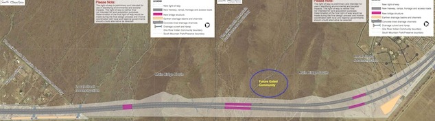
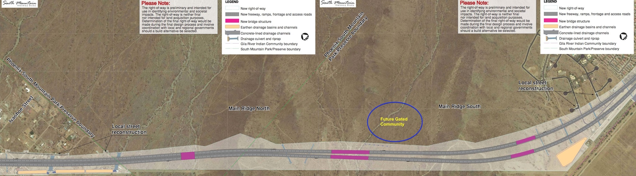
April 13, 2015: Generally explored the west end of South Mountain Park, from Dusty Lane south to Pecos Rd, getting a feel for what was out there. Found several ruined ranches. First sign I found of the freeway, was the saguaros already tagged for relocation. (As a protected species in Arizona, saguaro cannot be legally chopped down.) Found black sheeting on north slope of Main Ridge South demarcating what I later learned would be a new luxury development (Taylor-Morrison’s Promontory at Foothills West). Found petroglyphs on outcropping on south slope of Main Ridge South. Condemned Dusty Lane properties still occupied.
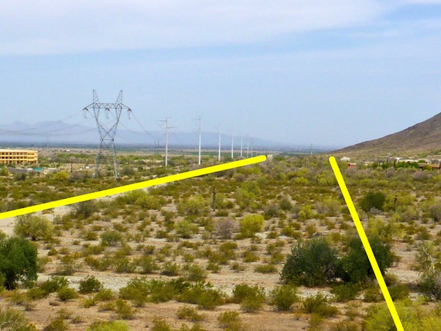
December 17, 2015: My first real survey hike, with a vision. My plan was to walk the exact Loop 202 South Mountain Freeway right-of-way from Pecos Rd. to Dusty Lane. Every ⅒ of a mile, I took a photo up the right-of-way so I could later compare the way the land looked before the freeway was built with how it looked after. (The comparison video is below.) The only notable changes were in Dusty Lane, where the properties around Choppo Rd. had been abandoned; those further north were still occupied.
April 29, 2016: Houses at the west end of Pecos Rd. torn down and the remaining condemned Dusty Lane properties abandoned. Found a saguaro nursery near Pecos Rd.
October 28, 2016: Extensive earthmoving, including dirt access road, for future Promontory at Foothills West gated community. Several marked wood stakes between Pecos Rd. pump station and Main Ridge South. Destruction of Choppo Rd. houses in progress.
April 28, 2017: Found fresh tags & “throwies” at what I dubbed Graffiti Ranch. Promontory at Foothills West dirt access road improvements. Construction worker parking lot at Pecos Rd. pump station. Petroglyph outcropping demarcated by curved line of metal rods. All condemned Dusty Lane properties removed.
November 8, 2017: As far as I could tell, not one pebble had been moved along the Loop 202 South Mountain Freeway right-of-way, so I spent my survey hike documenting all the old ranches between Main Ridge South and Main Ridge North. At Graffiti Ranch, the wall with the beautiful pieces had been torn down and the remaining walls whitewashed. R.A. Steele Ranch ruins removed. (They will be under the northbound lanes.) Promontory at Foothills West access road paved; houses being built.
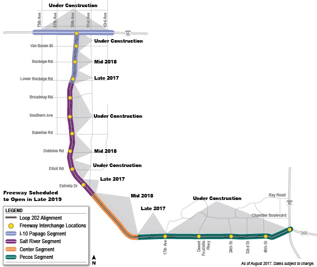
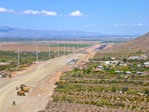
April 20, 2018: Construction of the Loop 202 South Mountain Freeway’s Center Segment — which is what my survey hikes covered — was scheduled to begin this Spring. Indeed, a construction access road had been built from Pecos Rd. over Main Ridge South and Main Ridge North to Dusty Lane. Water reservoirs — for dust abatement — built at Pecos Rd., the luxury development, and Vee Quiva Casino. Top of Main Ridge South being levelled. Each power tower had a seismograph, for blasting the cuts in the ridges.
November 7, 2018: Extensive prep work & base buildup from Pecos Rd. through Dusty Lane to 51st Ave. Culverts being installed; some complete. Deep cut in Main Ridge South.
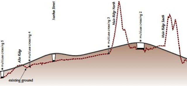
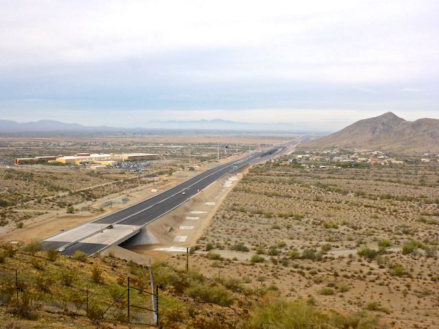
April 6, 2019: Loop 202 South Mountain Freeway still scheduled for completion by end of 2019. The Rock Wall Ranch ruins removed, despite being off the Loop 202 South Mountain Freeway right-of-way. Pecos Rd. pump station removed. Deep cut in Main Ridge North. Surface paved south as far as Alta Ridge.
December 7, 2019: Bridges over multi-use crossings complete. Full length of Center Segment paved & signed. Sound walls built along Pecos Rd., Promontory at Foothills West gated community and Dusty Lane. People living in the luxury development — and already complaining about freeway sounds. Well, duh, what did you expect being 100 yds. from the damn thing?
In 2015, there was a lot of anti-freeway meetings & talk. The reasons varied: On sacred Indian land, would destroy pristine Sonoran Desert, would cost many people their homes, etc. What I found on my 10 survey hikes was that only the latter was true.
The businesses along Pecos Rd., and the people living there and in Dusty Lane, had their lives upended. No doubt about it.
If, however, one considers the petroglyphs sacred, they were protected by routing around them. No actual Gila River Indian Community land was crossed by the Loop 202 South Mountain Freeway (Or Ed Pastor Freeway, as it has since been named.)
As for impact on South Mountain Park, only 31.3 of 16,283 acres, or 0.2%, at its very westernmost reaches were consumed by the freeway, and those were wasteland, dotted with garbage and old ranch ruins.
The Loop 202 South Mountain Freeway opened on December 21, 2019, just two weeks after my last survey hike. It was intended to relieve I-10 traffic, especially trucks, between downtown Phoenix and Chandler. As of my final drive (below), a month later, traffic was light and there were few trucks. Hopefully, that changes …
Before & After Video
Loop 202 South Mountain Freeway: Wrap Up from Preston McMurry on Vimeo.