

After being sick most of January, I need to build up some long distance hiking strength for my March trip to Aravaipa Canyon. (Or what is “long distance” for me.) Though February has been warm in Arizona, I didn’t want to risk possibly chilly mid-elevation weather in some place like Prescott.
I occasionally search for hikes in the Wickenburg area, and always come up empty. This time, I found something promising: The Sophie’s Flat Trail System, just two miles northeast of Wickenburg, near the Hassayampa River. As far as I could determine, Sophie’s Flat has four designated trails: Red Top Loop Trail A, plus connector trails B, C and D. Supposedly there is an E and F, but I couldn’t find them. 🤔
The Wickenburg Mountains are riddled with OHV trails, but the Sophie’s Flat Trail System is strictly “no motor vehicles”. The rodeo arena you pass on the drive in testifies to Sophie’s Flat popularity with horse people. The trailhead has room for 25 horse trailers, hitching posts, two pit toilets (no TP!), info kiosk, sign-in stand, and cabana with two picnic tables.
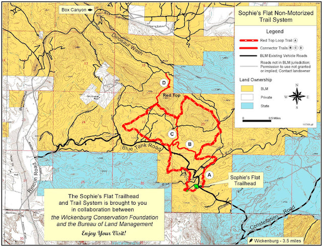
Red Top Loop Trail A starts between the cabana and pit toilets. Setting a theme for the day, Red Top Loop Trail A crosses one small wash, travels the sandy bottom of Blue Tank Wash, crosses over a jeep trail on a spur, then drops into another large sandy wash. It was there I made my first of several wrong turns, onto Trail B. It’s easy to do with so many jeep & foot trails criss-crossing Sophie’s Flat.
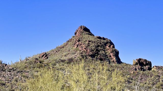
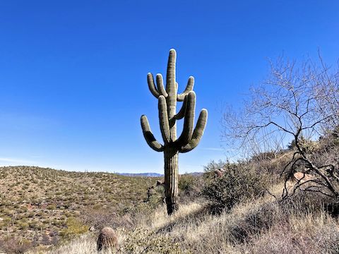
Rather than route along the hard desert top of a spur, Red Top Loop Trail A remains in the large sandy wash for ¾ miles to a jeep trail on the southeast slope of Sophie’s Flat Peak (Hill 3191, the next hill southeast of Red Top.) The highlight of the drudgery was the tallest ocotillo I’ve ever seen. Towering. 😲
If you continue on the jeep trail, it will take you to the head of Dinosaur Wash. Instead, after 300 yds., turn left onto singletrack along Hill 3191’s east slope. Other than the scenic bottom of Dinosaur Wash, the next ¾ mile were the highlight of my day, grassy, with decent views: Yarnell Hill, and the flat top of the Antelope Hill mesa were clearly visible 14 miles away.
The Trail C junction is just on the west side of the saddle. From there, along Trail C, it is 2¼ miles back to Sophie’s Flat Trailhead. Instead, turn right on Trail A, along the west slope of Red Top. The next ½ mile is often off camber, with gravel over rock, so take care lest you slip and take a tumble.
At 3¾ miles, the Trail D intersection is just over halfway into Red Top Loop Trail A. Even if you decide to only do the loop, at least head up Trail D 200 yds., to the saddle between Red Top and Creighton Peak (Hill 3064). Then turn around and admire the Wickenburg panorama: from Vulture Peak (11 miles southwest), clockwise across Wickenburg, to the Harcuvar Mountains (38 miles west). ⛰
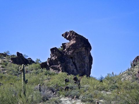
From the saddle, Trail D drops 250 ft. in a half mile to a very small wash. Near the bottom of the descent, the stegosaurus rock formation first comes into view, to your left, on the north ridge of Creighton Peak. Trail D signs continue down the wash for ¼ mile to Dinosaur Wash. (The small wash has a short bypass, left of a small, difficult to climb down, dryfall.)
For most of my day on Sophie’s Flat and in Dinosaur Wash, I took each photograph twice, first with my iPhone SE, then with the Ricoh WG-6. That way I could compare the two while testing the Ricoh WG-6. The iPhone SE did much better on terrain, cactus, geology and object shots. Clearer, with better color balance. The Ricoh WG-6 took nice flower photos. Last week.
This week, there were no desert flowers: None. Zip. Zilch. Zero. Not even brittlebush, creosote or scorpionweed — the Sonoran Desert’s three most common winter flowers. I was surpised, considering we had a solid winter monsoon, Wickenburg seems to get more rain than Phoenix, and the temps were in the low 60s. 🤷🏻♂️
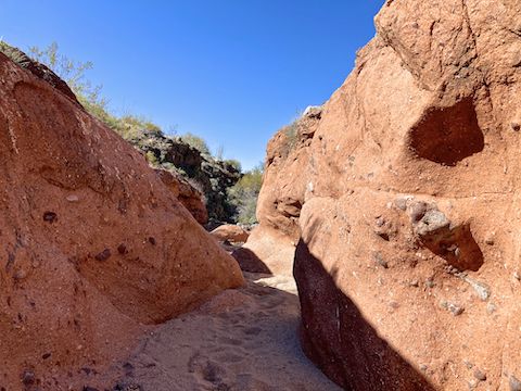
Dinosaur Wash had amazing geology! Sections of narrow pink congolmerate slot canyon alternating with wide & sandy sections with dark, lichen-splattered, granite. I was taking my time, oohing and aahing at the rocks, so I only made it halfway to Box Canyon by 1 p.m., three hours into my hike.
With a solid five miles to Sophie’s Flat Trailhead, I decided to bail. Back at the Red Top / Creighton Peak saddle, I found some shade and finished my lunch. I had Verizon 2-bar LTE, so I texted my wife to let her know I was on my way.
The second half of Red Top Loop Trail A was more of the same and seemed to drag on forever. I questioned why the trail designer was so cruel, crossing all those washes, rather than routing down a spur more directly towards the trailhead. The trail even crossed Blue Tank Road twice, and Blue Tank Wash for a second time. I thought about thumbing down an OHV, but I needed to put the work in. 😅
With no flowers to photograph, and slow me down, I made it back to Sophie’s Flat Trailhead at 3:44 p.m. After rehydrating, and debriefing my wife, we headed into Wickenburg for a date night dinner at El Ranchero, the city’s ****½ top-rated Mexican joint.
Directions: From Phoenix, head northwest on US-60 to Wickenburg. As the road curves downhill to the Hassayampa River bridge, turn right between the Tastee Freeze and McDonald’s, onto paved El Recreo Dr. In two miles, the road turns into car drivable dirt. In another mile, split left onto dirt Blue Tank Rd. Sophie’s Flat Trailhead is 1½ miles ahead on the right.
GPS File: Sophies_Flat_Trail_System
Distance: 11.48 mi.
AEG: 1,466 ft.
Time: 4h 36m
Hiking Video
NEW! Hiking Sophie’s Flat & Dinosaur Wash from Preston McMurry on Vimeo.