

Counter-clockwise from Bronco Trailhead, this is the 4th and 5th segment of the Maricopa Trail.
At the beginning of 2021, I set out to hike the entire 245-mile Maricopa Trail. Before today, I had completed only 26 miles. Needing to up my game, I decided I would do one segment per month over the winter. You sure as hell don’t want to it when it is 110° in July! 😅
With 90-100 miles of the Maricopa Trail being canals, or even city streets, frankly the drudgery of hiking walking those miles would be overwhelming. Since I cannot honestly say “I did it” if I didn’t do all 245 miles, the solution I came up with is to bike the roads & canals. At least I would get them done quicker.
I’m not sure what the official Maricopa Trail segments are, but for me the 4th segment is from the Daisy Mountain F.D., in Anthem, 8⅓ miles to the Bob Bentley TH, on Carefree Highway. And my 5th segment is from Bob Bentley TH 10⅓ miles to the Agua Fria Trailhead, at Lake Pleasant.

Since it is 1⅓ miles from the Maricopa Trail to Bob Bentley TH, hiking straight through from Anthem to Lake Pleasant is 16 miles. I juggled the pros and cons of doing the segments as separate hikes, but ultimately decided to the whole shot in one day. The flat terrain — only 400 ft. of accumulated elevation gain (AEG) — made it doable for this 59-year old fat man.
The distance necessitated my always supportive non-hiking wife performing shuttle duties. I could have hiked segment #4 out & back, but why repeat terrain that is not all that exciting anyway? Biscuit Flat is not the Mogollon Rim! 😉
I started hiking west from the Daisy Mountain F.D. at 7:20 a.m. The first couple of miles are a locals hike between Desert Hills Dr., on the left, and Meridian Dr., on the right. The Maricopa Trail often has deep, dusty, sections but is never rocky. The first two miles have low desert shrubbery; the third mile along Deadman Wash is more woodsy. There was lots of traffic on the roads, but no people or horses on the trail.
At three miles, the Maricopa Trail crosses under Gavilan Peak Pkwy. Tall folks may need to duck. A ½ mile west, the trail crosses under I-17, the Black Canyon Freeway. There wasn’t as much graffiti as I expected under the bridges. On the west side of I-17, the trail turns south. After “climbing” 30 ft., the trail turns west, crossing an old burn area along Deadman Wash as it approaches the FCI Phoenix road.
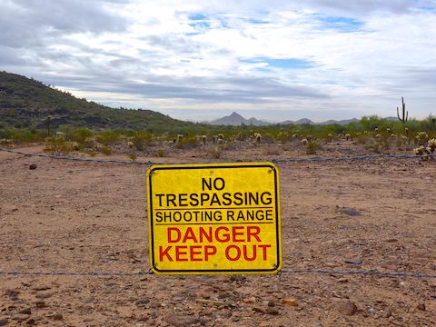
At five miles, on the other side of the FCI Phoenix road, the Maricopa Trail continues as a power line paralleling jeep trail. If you hear shooting that is the Ben Avery Shooting Range to your left, not a prison break to your right. After ¾ mile, turn south along a combination of rougher jeep trail and singletrack for another mile. 🔫
Just before seven miles, turn west on a unnumbered jeep trail crossing Biscuit Flat. If, instead, you continue south, the Bob Bentley TH is in 1⅓ miles. The next two miles are a water and fibre optic right-of-way, with many pipes, pumps and manholes. There were signs indicating the Maricopa Trail was against the fence on the right, but I don’t think anyone ever used that part, as it is all grassed over. I mean, why bother, when the jeep trail is perfectly serviceable?
At nine miles, the Maricopa Trail passes through the middle of a CEMEX gravel quarry. Just past the quarry, the jeep trail takes a jog to the right, then crosses the dry New River flood plain. In a ½ mile, the jeep trail turns north, following the power line. Instead, continue straight onto single track. (Normally, there are plenty of trail signs, but this bit was confusing.)
At 10 miles, the Maricopa Trail “climbs” 30 ft. out of the New River bottom. Turning north, it becomes bluff edge jeep trail. Again, there was trail trail a few yards away, but why bother? Especially when several rubber tramps had parked their ratty RVs / mobile meth labs across it? 💉
Still following the bluff, the Maricopa Trail returns to single track after crossing an unnamed paved road. The trail crosses some small washes which might test a mountain bike, but not a hiker. When the trail nears a second quarry, it bends northwest. Mind the small jumping cholla grove.
After crossing New River Rd., just short of 13 miles, the Maricopa Trail passes under two sets of 500 kV power lines. One set was loudly crackling, the other I could not hear. Wonder why? Good thing I already reproduced!
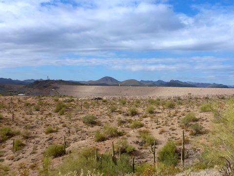
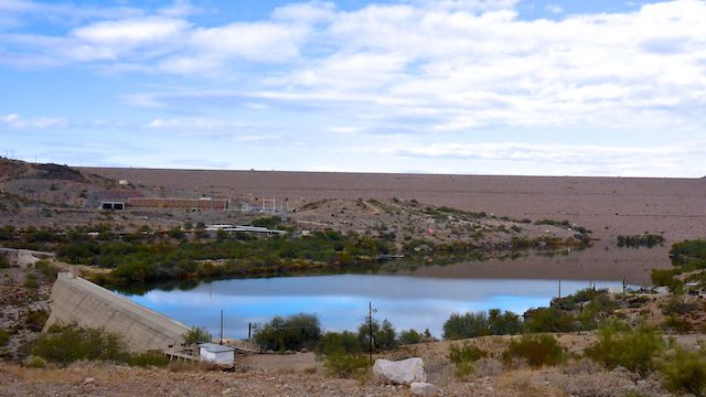
The Maricopa Trail is jeep trail to 87th Ave. After crossing the busy Lake Pleasant access road, the trail is singletrack as it parallels the south edge of the Pleasant Harbor RV Resort. At the west end of the old fogie trailer park, at 14 miles, New Waddell Dam hoves into view. Overcast most of the day, I caught it in a brief sunny window. 📸
The Maricopa Trail then descends 200 ft. in a ½ mile into a wash — the only real elevation change on this hike. The wash was my favorite part of the day, as it was isolated & quiet. No sounds of rushing vehicles or buzzing planes. (Of which there are always many around Lake Pleasant.)
At 15 miles, near the Hank Raymond Lodge, the Maricopa Trail climbs out of the wash, winds around a canal, then follows Sunset Point Rd. to the Agua Fria Trailhead.
I had stubbed my toe pretty good descending to the wash, and I definitely had blisters, so I was happy to finish the third longest hike since I took up this hobby. (The longest being 18.35 miles from Great Falls to Edwards Ferry on the C&O Canal, and second longest a 18.28 mile through hike of Aravaipa Canyon.)
My recommendation, if you want to complete the Maricopa Trail, is to do cut this hike in half: First Anthem to Bob Bentley TH, and later from Bob Bentley TH to Lake Pleasant. 😉
Anthem TH Directions: Head north on I-17 to exit 223A. Go east on AZ-74 / Carefree Highway for 3.0 miles. Turn left on 7th Ave. In 3.0 miles, turn left on Desert Hills Dr. Take the next right at the brown Maricopa Trail sign. Park in back of the Daisy Mountain Fire Department.
Bob Bentley TH Directions: From Phoenix, head north on I-17 to Exit 223B. Go west on AZ-74 / Carefree Highway. The Bob Bentley Trailhead is on the right, one mile past the stoplight at the Arizona Game & Fish complex. There’s lots of traffic on AZ-74 so, for security sake, I would drive through the gate and park behind some palo verde.
Agua Fria TH Directions: Continue west on AZ-74 / Carefree Highway, past the Bob Bentley Trailhead. By Lake Pleasant, at the bottom of the hill, just after you cross the second bridge, turn right onto Beardsley CSR Rd. The Agua Fria Trailhead is straight ahead, on the left.
GPS File: Maricopa_Trail_Anthem_TH_to_Lake_Pleasant
Distance: 17.97 mi.
AEG: 445 ft.
Time: 6h 16m
Hike Video
Maricopa Trail: Anthem to Lake Pleasant from Preston McMurry on Vimeo.