

I’ve hiked around Woods Canyon Lake several times, but I’ve never been down the canyon it drains into. The lake is my favorite place in Arizona, so when I am hiking anywhere near, I like to stop by the bait shop afterwards for a Good Humor ice cream and ice cold hiking beer. 🍺
But I’ve never been to Willow Springs Lake, which is only 3½ miles southeast of Woods Canyon Lake, right on the corner of Rim Rd. / FR 300 and AZ-260. So, I decided to link the two, by hiking their respective canyons: From Willow Springs Lake, north 3.7 miles down Willow Springs Canyon to Chevelon Canyon, then southwest 5.8 miles up Woods Canyon to Woods Canyon Lake.
The route looked like it might be rocky in spots, but did not appear to be any worse than Miller Canyon at McCarty Draw. If I had to, I thought I could bail up bluff to a forest road like FR 502, strolling the rest of the way to Woods Canyon Lake. I did end up taking FR 502, but not the way I intended …
Before I go any further, let me just say that unless you are very strong hiker, you should avoid attempting the full Willow Springs Lake to Woods Canyon Lake thru hike. A much less strenuous — and safer — option would be to turn around when the foot trail fades away around 1.7 miles. If you fancy a bit of canyon crawling, two miles at most. ✋
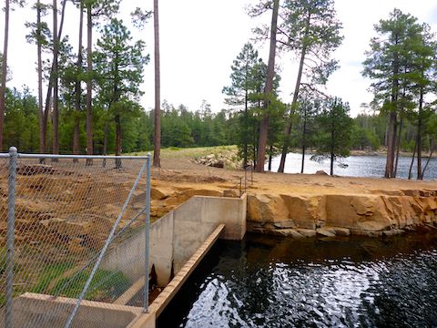
From the Willow Springs Lake parking area, follow the paved path or use trail north along the shore, towards the spillway. Follow the spillway’s chain link fence until the end, then climb down into the spillway. It’s easy. If you turn back, you will have done a flat round trip hike of ¾ of a mile.
When the spillway makes the 90° turn, pick up the trail on the right side of concrete bed. The spillway should be dry, but the creek at the bottom will still be flowing even deep into dry season. Then simply follow the obvious trail north, along the creek. At 1.2 miles from the Willow Springs Lake boat ramp, there is what appears to be an old creekside road that may be an extension of FR 9504X. You may be able to loop that, otherwise turn around after no more than 1.7 miles, two at most.
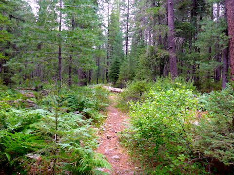
Including photo stops, it took me 39 minutes to hike the first 1.7 miles. When it took me 30 minutes to canyon crawl the next 0.3 miles, after the trail disappeared, I should have realized what I was getting myself into and turned around. But I forged on.
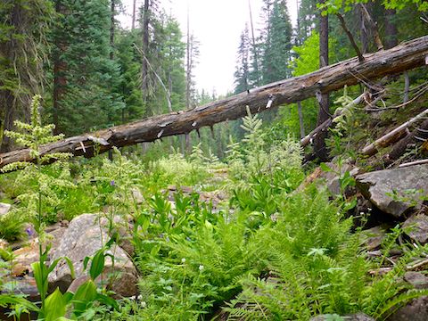
Both along the trail, and further into Willow Springs Canyon and Woods Canyon, the terrain is unscarred by fire. Not even ancient fire. Lots of very tall pine trees above, and flowers down low. There were dense clusters of sneezeweed, false hellebore (corn lily) and wild bergamot. When corn lily are immature, they are no hindrance to travel, but at 5 ft. tall, with thick stalks, I felt like I was trying to fight my way through stiff-limbed manzanita. The lavender-colored wild bergamot were covered in docile orange Atlantis fritillary butterflies in the afternoon (by which point I was too tired to stop & photograph them). 🦋
If I have not dissuaded you from going further down Willow Springs Canyon, this should: It took me over two hours to hike the third mile. (Including photo ops, route finding, and other low / no movement activity.) I knew the canyon crawling was taking awhile, but I had no idea how fast time was flying. Losing track of time as the travel became more difficult — much more difficult — was my first mistake.
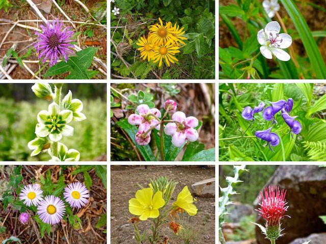
Top Row: wild bergamot, sneezeweed, Richardson’s geranium.
Middle Row: false hellebore (corn lily), common pipsissewa, columbia monkshood.
Bottom Row: fleabane, desert evening primrose, Arizona thistle.
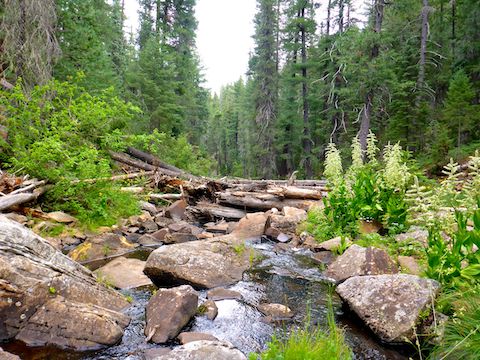
My second mistake was not realizing I had bit off more than I could chew, and turning back. Willow Springs Canyon is no joke. It is the rockiest canyon, by far, that I’ve hiked on the Mogollon Rim: A difficult, unceasing, combination of big boulders and ankle breakers, with very few, very short, flat shelves to bypass the obstacles.
Making forward progress even slower is frequent heavy ground cover obscuring the boulders, including corn lily and an abundance of tripper vines. Hiking Willow Springs Canyon and Woods Canyon is like negotiating Walnut Creek north of Lake Mary Rd., except mile after mile after mile. By the time I’d hit mile marker three I’d had enough. But I continued all the way to Chevelon Canyon. 🙄
Willow Springs Canyon’s floor also descends quicker than it’s rim, so that it gets deeper, from 150 ft. where you really should turn around (two miles in), to 500 ft. deep at the junction with Chevelon Canyon and Woods Canyon. Though not vertical, the canyon walls are exceptionally steep and choked with more tripper vines, deadfall and rock slides.
I figured since FR 502 went right up to the rim of the Chevelon Canyon, Willow Springs Canyon and Woods Canyon junction, there was a good chance there would be a use trail from the forest road down to the canyon bottom. There wasn’t. Not that I could find. So, I picked what looked like a relatively decent route and headed up. The soil was loose, and it was steep enough that at one point I was on hands & knees. 150 ft. up, I hit a cliff band. Fuck. Back down I went. 😫
Trying to bail up the bluff sapped all my remaining energy.
Long story short, I called EndEx.
In case it I didn’t make the point strongly enough, earlier, you really should avoid going any further than two miles down Willow Springs Canyon.
Willow Springs Lake Directions: From Phoenix, head north on AZ-87, the Beeline Highway, to the main intersection in Payson. Head east on AZ-260. Just east of Payson is the hamlet of Star Valley, which once was an infamous speed trap with three speed cameras in only a half mile. That ended in March, 2016, but the speed limit is still 45 mph. In 30 miles, just under a mile after AZ-260 tops the Rim, turn left onto paved FR 149 towards Willow Springs Lake. In a mile, park near the boat ramp.
GPS File: Willow_Springs_Canyon
Distance: 6.62 mi.
AEG: 516 ft.
Time: 4h 42m
Hiking Video
Hiking Willow Springs Canyon, Mogollon Rim from Preston McMurry on Vimeo.