
. Not sure how I figured this out, as it was only 1% likely on Wildflowersearch.org for elevation, color, size, etc. But it exactly matches the closeup on wikipedia. What a find!")
Heading east from Dewey, this is the first part of the 6th segment of General Crook Trail.
Even though it is late June, the managed Wilbur Fire is still burning north of the AZ-260 / AZ-87 junction — the area which the fifth segment traverses. This week being the tenth annversary of the Yarnell Hill Fire, it would not be wise, or legal, to enter the Wilbur Fire burn area. So, I skipped ahead a segment.
The sixth segment of the General Crook Trail is from Baker Lake (V33) to General Springs (V43). Despite the distance only being 10 official miles, the track is well over 12 miles. On my four previous General Crook Trail hikes, my mileage — which includes wandering & backtracking — runs about 1.2x the Boy Scout track. That means I would likely end up hiking over 15 miles. Long day! ⏳
I could do it, but decided instead to break the sixth General Crook Trail segment up into two hikes, and instead have a picnic with my wife at the end of this one.
This General Crook Trail segment starts at Baker Lake, just off of AZ-87 on Rim Road. Like other segments, depending on the source, the route varies. Lacking road graders any more sophisticated than a trooper with a pickaxe, I’m sure the original route followed the line of least elevation change. 🪓
Yards to the south, the General Crook Trail would be over a cliff while not much further the other side are numerous perpendicular canyons. (Many of which I’ve explored, such as nearby Quaking Aspen Canyon.) I tried my best, on the fly, to find the “true” route: looking for chevrons, gabions and mileposts left by the Boy Scouts in 1976, or even old road bed where I could find it. I started hiking at 8:40 a.m.
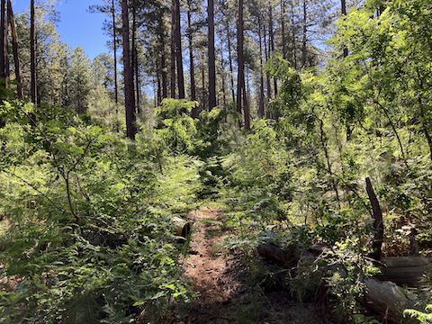
Baker Lake was no more than reeds. Across Rim Road from Baker Lake are the first two whitish-silver chevrons. I aimed between them, following a foot trail. Though covered by pine needles, it was still obvious. I soon had to divert around a tangle of deadfall. Not for the last time. After ¼ mile, General Crook Trail crosses Rim Road. Also not for the last time.
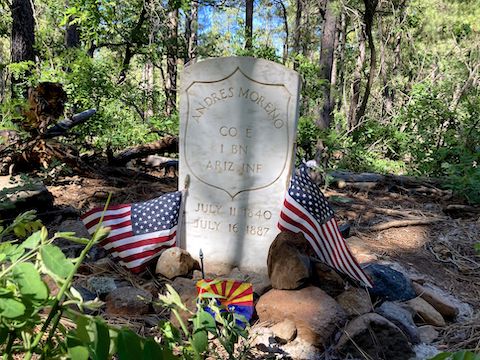
While negotiating a rather large log blocking the General Crook Trail, I stumbled upon the grave of Andres Moreno, which I was not expecting for another ⅓ mile. After crossing Rim Road for a second time, the trail resembles old roadbed, passing by a portapotty. Across Rim Road is FR 308B, which is a 170 ft. climb to the summit of Baker Butte. The lookout appears to still be active, but no one was home.
There’s a spaghetti of forest roads surrounding Baker Butte. After descending FR 308B, I lost the General Crook Trail chevrons passing by some campsites near FR 9381L. I regained the trail, crossed Rim Road for the third time (at 1¾ miles), fourth time (2 miles), was briefly on it (2¼ miles), then crossed it again, a fifth and sixth time just a hundred yards apart (2⅔ miles). You get the idea. 🛻💨
I quickly lost the General Crook Trail in an old burn area, riddled with deadfall and stinging nettles. That got old quick. I bailed to Rim Road, and good thing I did as I almost bumped into mile marker V36, it was so close to the road. (P markers are for miles from Camp Verde west to Prescott; V for miles from Camp Verde east to Fort Apache.) I’ve been unable to find other references to V36, so it was a sweet find.
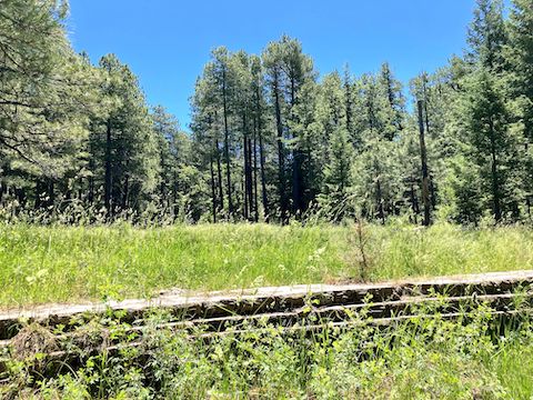
After crossing the Lee Johnson Spring meadow, I picked up a chevron, resuming the General Crook Trail. The next ⅔ mile was a grassy, flat, old road bed. I’m not sure if it is the original Old West-era cavalry road, or decommissioned jeep trail. Other than on Rim Road, there was plenty of shade.
As indicated by chevrons, after 4⅓ miles, General Crook Trail merged with Rim Road. On a Wednesday, there wasn’t too much traffic. A lady driving an SUV stopped to chat about my hike. I saw one pickup / fifth wheel drive by twice, searching for a good camping spot. 🤔
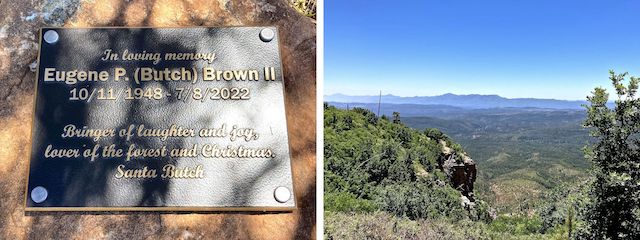
I made good time on Rim Road — at least when I was moving. Just past FR 308, Rim Road makes its closest approach to the Mogollon Rim, at a small knoll. I started up decommissioned FR 9265, when I noticed a log bench by the pullout. Next to the bench was a roadside memorial for Eugene P. Brown II. (Interesting guy.) Good thing I stopped, because that’s where I found the Bachelor’s Button flowers.
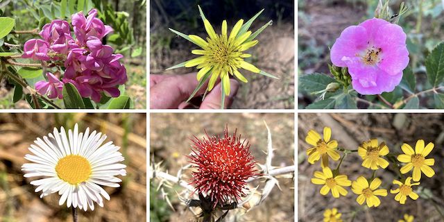
Top Row: New Mexico locust, yellow salsify, Wood’s rose.
Bottom Row: spreading fleabane, Arizona thistle, showy goldeneye.
Other high country flowers I found included American vetch, Richardson’s geranium, alpine false springparsley, some rather decrepit goldenbanner, and very tiny pygmy bluet. But the highlight, by far, was the Bachelor’s Button (Centaurea cyanus)!
After Santa Butch’s memorial, I continued on Rim Road, until the chevrons led off to the right (5¾ miles). General Crook Trail spent a quarter mile in the upper reaches of Kehl Canyon. At least it wasn’t Rim Road, which was just 100 ft. away. 🤷🏻♂️
Back on Rim Road again, it was just under a half mile of chevrons to Kehl Spring Campground and a post-hike picnic with my loving shuttle driver of nearly fifteen years. She had a turkey murderwich, and I ate an Italian wrap. As if the Lay’s jalapeno chips were not enough, on the way home I was so excited to spot Herr’s at a gas station in Arizona, that I picked up a bag of ghost pepper chips as well.
Baker Lake Directions: From Phoenix, head north on AZ-87, the Beeline Highway, through Payson, Pine and Strawberry. (Alternately, take I-17 north, then AZ-260 east.) 2.6 miles north of AZ-260, turn right onto Rim Rd. / FR 300. Pull over by all the signs. Baker Lake is on your right.
Kehl Spring Campground Directions: Continue east on Rim Rd. / FR 300, In 6.8 miles, just before FR 141, turn left into the Kehl Spring Campground. The day use fee is $8.
GPS File: General_Crook_Trail_V33_V39
Distance: 9.31 mi.
AEG: 1,101 ft.
Time: 3h 34m
Hike Video
Hiking General Crook Trail: V33-V39 from Preston McMurry on Vimeo.