

Unless you count North Mountain, I haven’t hiked much the past month. (In fact, just once, Butterfly Trail #16 in the Catalinas.) We’ve had record setting rain during the summer monsoon, and I figure it is wise to avoid getting sick. Particularly these days …
If any place in northern Arizona gets rain, it is the Mogollon Rim, which was predicted to be sunny all Thursday. So, I planned a loop hike of Turkey Springs Trail #217 and West Webber Trail #228. 🌤
The loop itself is about 5.6 miles, 1,530 ft. AEG (accumulated elevation gain). You can either hike from the top of the Mogollon Rim, on Milk Ranch Point, as I did, or from the bottom, at Camp Geronimo’s front gate. The latter adds 5.0 miles, 700 AEG, in & out to Turkey Spring. (If you are a Boy Scout, and have legal access to the camp, you hike out the back of camp, saving the five miles.)
Most people who hike the Turkey Springs Trail #217 and West Webber Trail #228 loop, use Dickenson Flat for a trailhead. Trail #217 has more expansive views, but Trail #228 is steeper. Either way, starting on Milk Ranch Point means you will be heading up the second half of your hike. I chose to hike clockwise, heading down Trail #217, then up Trail #228.
Starting at the unnamed tank, then walking north on FR 218, gave me a chance to warmup my legs for 1½ easy miles before tackling the Turkey Springs Trail #217 descent. For readers who don’t normally tackle steep trails, here’s how they differ:
A steep ascent is harder on your cardiovascular system, and works the calf muscles. It’s also easier to negotiate tricky / slippery trail surfaces. On the other hand, a steep descent works the quadriceps, as you use your muscles to brake, rather than propel, particularly on tricky / slippery surfaces. 💔
Parked by an unnamed tank, so my stay behind wife could look out for elk, I warmed up my muscles by first hiking north on FR 218, past several great camping spots, to Dickenson Flat. There were a few mullein and Wheeler’s thistle along FR 218, but primrose were the most common flower. (Though still rare.) At the north end of Dickenson Flat, I turned right onto decommissioned FR 9381F.
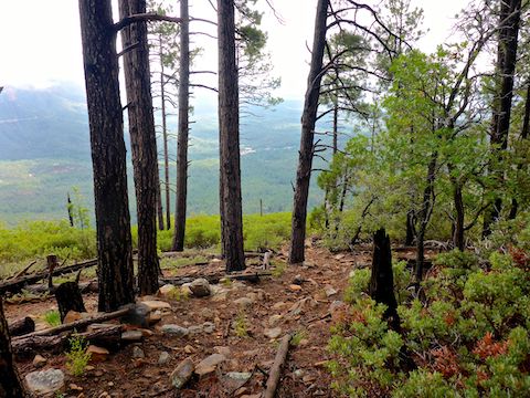
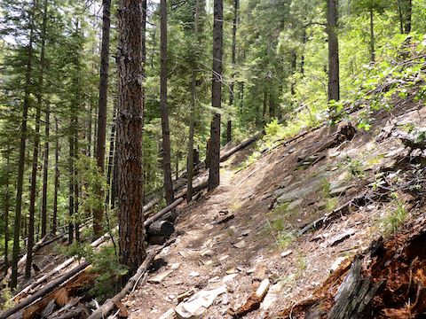
150 yds. past the FR 9381F vehicle gate, there is a sign for Turkey Springs Trail #217, which splits to the left. The half mile of Trail #217 in the Coconino National Forest is indeed forested, with decent shade. A barbed wire fence and wire loop gate marked the boundary with the Tonto National Forest. 🌲
Past the fence, Turkey Springs Trail #217 began descending in earnest, mostly through a manzanita-strewn old burn area. In 2007, Trail #217 was reported to be vague and in poor shape, but it is now well-defined, though ankle-breaker rocks and slippery gravel-over-slick surfaces require caution.
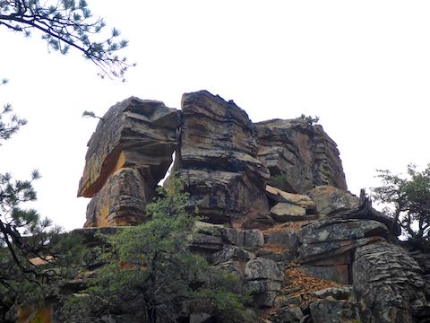
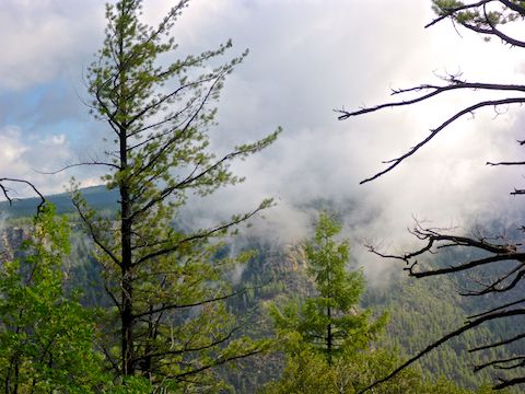
The top half of the Turkey Springs Trail #217 descent has great views along the Mogollon Rim, which were enhanced on my hike by the contrast of many puffy clouds. A ¼ mile past the barbed wire gate, on the south side of the trail, is a freestanding rock formation with a balanced rock. If you are careful, you can climb the 30-40 ft. to the top. I saved my energy.
The final ¼ mile, Turkey Springs Trail #217 becomes deeply-rutted jeep trail. I’m not sure if the erosion is recent, but I would not be surprised if it was: Nearby Payson has had over 11″ of rain during this summer’s record monsoon season. ☔️
After 3½ total miles, I turned off Turkey Springs Trail #217 onto West Webber Trail #228, which drops slightly to a small, unnamed creek. I found a good tree stump, sitting down to a lunch of vinegar chips, gorp and gas station murderwich. Today’s hiking beer was Chimay Grande Réserve.
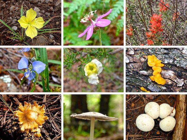
Top Row: primrose, pineywoods geranium, paintbrush.
Middle Row: western dayflower, Stansbury’s cliffrose, orange jelly.
Bottom Row: I don’t know from fungi.
As it heads up canyon, West Webber Trail #228 crosses the small, unnamed, creek several times. I was always able to cross it dry. The creek’s low volume flow was loud enough I could hear it 50 ft. upslope.
West Webber Trail #228 had consistent, quality, shade it’s whole length. Between the creek and the overhead cover, the ground was moister. As a result, below the Rim, Trail #228 had fewer flowers and much more fungi than Turkey Springs Trail #217. 🍄
The first mile of West Webber Trail #228 climbs 450 ft., while the next ¾ of a mile climbs a heavily switchbacked 800 ft. Just below the top of the Mogollon Rim, was an outcropping painted “HAVE”, with what looked like a cave opening. Turned out to just be a crack filled with rocks and leaf litter. From the top of the climb, it was only ⅓ of a mile back my wife at the unnamed tank.
Overall, I enjoyed the whole loop, but especially West Webber Trail #228. I look forward to doing it again in a few years, if I am not too old. Or fat. 😁
Directions: From Phoenix, head north on AZ-87, the Beeline Highway, through Payson, Pine and Strawberry. (Alternately, take I-17 north, then AZ-260 east.) 2.6 miles north of AZ-260, turn right onto Rim Rd. / FR 300. In 200 yds., where Rim Rd. turns left, instead continue straight onto FR 218A. It’s twisty, and a bit narrow, so mind your speed. It is easily SUV-able, and even a car could make it, if it drives slow. In 1.4 miles, just past the brown Milk Ranch Point sign, split right onto FR 218. Dickenson Flat is two miles past the split, and the unnamed tank 1.5 miles past Dickenson Flat.
GPS File: Turkey_Springs_Trail_217_West_Webber_Trail_228
Distance: 6.59 miles
AEG: 1,560 ft.
Time: 3h 07m
Hiking Video
Hiking Turkey Springs Trail #217 & West Webber Trail #228 from Preston McMurry on Vimeo.