

Hard to believe it has been 10 months since my last Mogollon Rim canyon crawl, in West Leonard Canyon. Didn’t do one in April. Nor May. Nor even June. Today is the day I decided to correct that omission. Afterall, my goal is to explore every canyon on The Rim.
West Chevelon Canyon starts at forested Rim Road, extending 31 miles north, until it empties into Chevelon Canyon, in the scrubland just below Mormon Crossing on FR 504, the old Winslow-Heber Road. At least initially, West Chevelon Canyon is located between Willow Ridge and Porcupine Ridge, just a few miles west of Woods Canyon Lake. 🏞
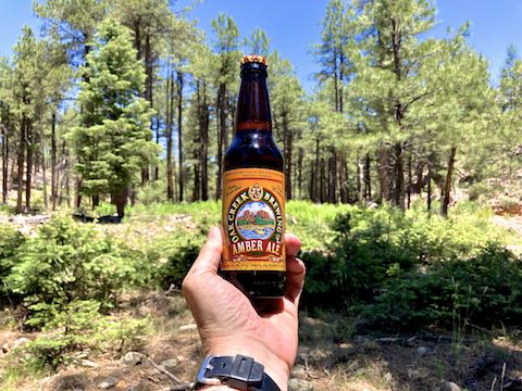
Thirty-one miles, even one way, is well-l-l outside my abilities, and West Chevelon Canyon gets deeper and more rugged as it goes. Thus, my plan was to hike it from Rim Road, 3⅔ miles north, make a short but steep climb out, and loop back on FR 34H and FR 34B to Rim Road. Then stop at the Woods Canyon Lake bait shop for ice cream. Can’t forget the ice cream.
If you decide to start somewhere along Porcupine Ridge, FR 34B is car-drivable as far as the FR 34H intersection. FR 34H is SUV-drivable for about another 1½ miles. The final ⅔ miles of FR 34H, to the bottom of West Chevelon Canyon, is strictly high clearance, 4×4. If you want to explore further down canyon, that will save you miles and time.
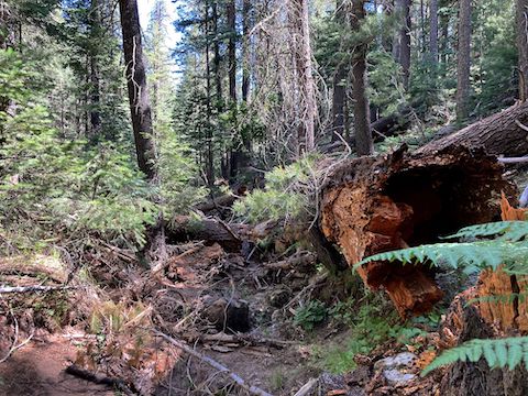
Instead, I started from the same trailhead I used for hiking Willow Creek, the next canyon to the west. Crossing FR 34, I “dropped into” West Chevelon Canyon. Like most Mogollon Rim canyons, the top of West Chevelon Canyon is relatively wide, shallow and uncongested. In other words, easy to access. The first half mile, or so, was smooth sailing. ⛵️
There were not a tremendous amount of flowers, but the most common ones were yellow columbine and Richardson’s geranium. Besides the high country flowers shown below, I also spotted tiny fleabane and Canada violet, alpine false springparsley, scarlet penstemon, goldenbanner, yellow salsify and lupine. I found my first ever woolly cinquefoil and second ever orange agoseris.
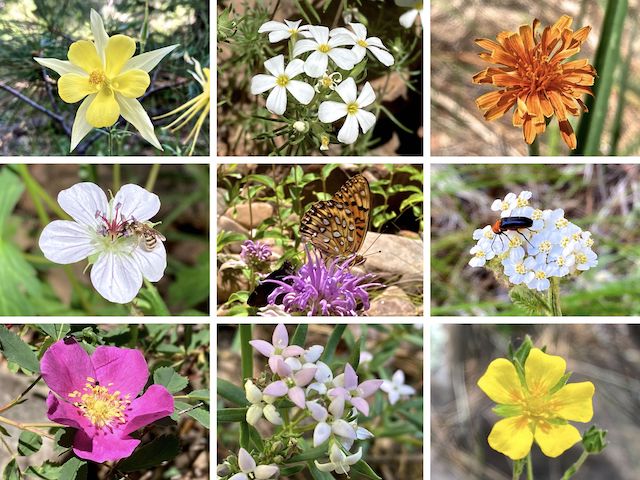
Top Row: yellow columbine, Nuttall’s linanthus, orange agoseris.
Middle Row: Richardson’s geranium, wild bergamot, western yarrow.
Bottom Row: Wood’s rose, pygmy bluet, woolly cinquefoil.
My West Chevelon Canyon GPS route (attached below) includes waymarks for each mile of this hike. I sometimes do that so I can track my progress during a hike, but I have not before included them in a route I’ve uploaded to a Kingsnake’s Home Den blog. Why? Because the miles you’ve hiked will not match your point on the route. Personally, due to wandering, I hike about 10-15% more than routed. 🤷🏻♂️
After the relatively clear first routed ½ mile, the next 1½ miles of West Chevelon Canyon are more congested, with decent size deadfall that can either be ducked under, or passed by on shelves. I only had to low crawl once. But I did knock my shins a half dozen times, and nearly tripped several more. (It’s the parallel branches, not perpendicular, that stab under my laces that cause me problems.)
Somewhere along that congested stretch of West Chevelon Canyon, I felt something wet on my arm. I looked down and “Oh, fuck, I’m bleeding.” Not just catclaw drops either. My sleeve was wet. I didn’t want to look. I could tell it wasn’t squirting, so I ignored it until I got to some sunlight. When I pulled my sleeve up, it turned out to just be a bad scratch. Which somehow did not tear my sleeve. Go figure.
It took me 40 minutes to bushwhack the first routed mile, 66 minutes to canyon crawl the second, and 50 minutes to hike the third routed mile. That seems slow, but the time was due to finding more flowers to photograph, rather than the obstacles at the bottom of West Chevelon Canyon: The final 1½ miles to FR 34H, have very little congestion, but are fairly rocky, with tiny pools, and occasional shelves.
There is nice mid-day shade on the shelf at the bottom of FR 34H. It’s a good picnic spot. I relaxed for a bit, eating my gas station murderwich, chips and gorp. I didn’t touch the salt lick. 🦌
On the left (northwest) of my West Chevelon Canyon rest spot, was a moderately sloped, relatively barren hill. According to my GPS mapset, “FR 34B” goes up it, but I saw no evidence of a road. In the middle, on the other side of the creek, was a spur that I thought I was supposed to head up on. Instead, back & and to the right (southeast), what appears to be creek bed is in fact FR 34H.
I hiked the 100 yds. across the face of the spur, then picked up FR 34H as the creek turns left (north) along the east side of the spur. (The turn is marked “FR 34H” on the attached GPS route.) In 150 yds., FR 34H turns right, up & out of the creek. It may seem like that creek is Alder Canyon, but it is not — it is unnamed, and ends up by the gravel pit on FR 300V.
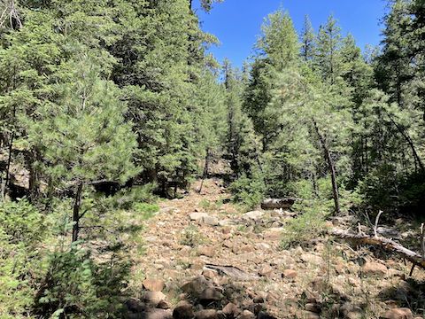
FR 34H climbs 200 rocky feet in just under a ½ mile. I wouldn’t want to drive it, but hiking it was a huge improvement on my often slippery & tangled canyon exits. The top of Porcupine Ridge is less densely forested than most Mogollon Rim ridges: It looks like it has been cleared to a historically normal tree density. Good for the Apache-Sitgreaves National Forest, but I missed the shade. 🫤
FR 34B was more of the same, with the addition of its own gravel pit, and several very littered campsites. I found several treasures, including a compass / whistle, a still good bungee cord and — best of all — a full 15-round Glock 9mm magazine. (Even better than the box of .22 long rifle I found while exploring Hargan Mine.) Christmas came early!
Directions: From Phoenix, head north on AZ-87, the Beeline Highway, into Payson. Turn right on AZ-260. In 29 miles, after cresting the Mogollon Rim, take the first left onto Rim Rd. / FR 300. In 3.2 miles, at the Woods Canyon Lake intersection, Rim Rd. changes to car-drivable dirt. 9.4 miles from AZ-260 is a t-intersection. Turn right onto FR 34. In a half mile, just past FR 34B, there is a small, rough, unsigned jeep trail on the left. Pull in there, and park at the fire ring. (If you continue north, you can drive FR 34 to Winslow.)
GPS File: West_Chevelon_Canyon
Distance: 8.59 mi.
AEG: 626 ft.
Time: 3h 53m
Hiking Video
Hiking West Chevelon Canyon, Mogollon Rim from Preston McMurry on Vimeo.