

My planned second “away bike” of the summer was for an area I’d both biked before (Campbell Mesa) and hiked before (Fisher Point). On the latter, I’d hiked over from Marshall Lake. Yesterday, the Bear Fire ignited barely two miles southeast of Fisher Point, on the south side of Walnut Canyon, near Marshall Lake. Emergency response jumped on it quick, so I didn’t expect to bail to another ride.
You could drive almost to Fisher Point on forest roads, but following the Flagstaff Loop Trail makes about four of the six miles singletrack. (I do not currently intend to add the 48-mile Flagstaff Loop Trail to my list of hiking projects.) 🚵🏻♂️
From Campbell Mesa Trailhead, I planned to ride south on paved Old Walnut Canyon Rd. for ⅓ mile; pick up the Flagstaff Loop Trail, heading south on FR 301D for one mile; split off onto singletrack, southwest past Dry Tank for 3½ miles; turn off the Flagstaff Loop Trail, south onto FR 301 for ⅔ miles; then ride a final ½ mile along indeterminate trail to Fisher Point. Finally, return on FR 301 and FR 301D.
The Flagstaff Loop Trail actually bypasses the Campbell Mesa Trailhead, via Sinagua Loop. So, I started my mountain bike ride by first heading south on paved Old Walnut Canyon Rd. for ⅓ mile. After passing under the powerline, and before the Walnut Canyon Ranch sign, Flagstaff Loop Trail crosses the road: Left to Sinagua Loop, right onto dirt FR 301D.
I didn’t check if the vehicle gate across FR 301D was locked: I instead went through the chain loop pedestrian gate on the right. To the left of FR 301D are forest and ranch buildings; to the right pasture. No cattle. FR 301D looked like hard packed dirt, yet it was deceptively sandy. Not enough sand to stop me, though enough to make my MTB squirrelly. FR 301D is also cut up with mud ruts. 🛞
At the one mile mark, FR 9133C splits right across the pasture, towards some old ranch ruins. I didn’t notice the ruins on the way out. At 1⅓ miles, an unnumbered forest road splits left. I accidentally turned down it. Go 100 yds. further, to where the Flagstaff Loop Trail splits left onto signed singletrack.
The Flagstaff Loop Trail singletrack climbs 35 ft. in less than 200 yds. (a 6.8% grade). The singletrack then more or less levels out for the next 1½ miles, crossing FR 9137D along the way. Mostly smooth to FR 9137D, the trail surface gets rockier after that. Enough so that I had to make an emergency stop. Let’s just say mullein — aka “cowboy toilet paper” — is insufficient. 😬
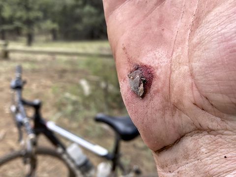
Flagstaff Loop Trail then crosses FR 9157 and climbs 55 ft. in ¼ mile. I’m a flatlander, so the elevation, combined with the rockiness, made the 4.2% grade seem steeper. I was sucking wind, so the slight descent over the next ⅔ mile was a relief. Before it crosses FR 301D, the singletrack splits. Stay left. I tried to make a sharp right, slid my front tire on a loose rock, and crashed.
Barely a minute later, making the rocky climb up from FR 301D, I got left of the Flagstaff Loop Trail singletrack, into the duff. Another front tire slide, and down I went. Harder. Scrapes on elbows, knee, knuckle and gouged my palm. The bruises stung more. I was back on my bike in less than a minute.
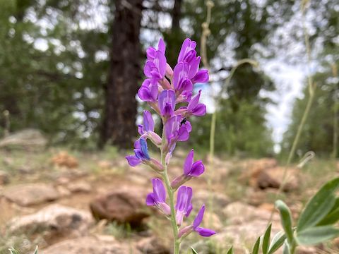
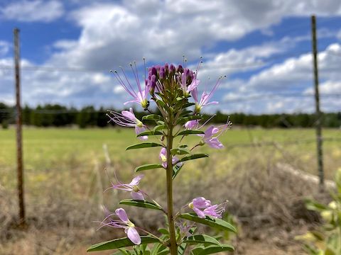
Tufted evening primrose was the most common flower on this Flagstaff Loop Trail segment. Other high country flowers I spotted include red & yellow pea, cliffrose, some wire lettuce-looking pink thing I’ve been trying to figure out for years, and either scarlet penstemon or skyrocket (did not stop to check). Should be better in a month. 🌻
From my second crash at Dry Tank, Flagstaff Loop Trail makes a rocky 3.0% 50 ft. climb up a wash. Still singletrack, however I needed a breather. (There’s only so much I can do at home when Phoenix is in the midst of two weeks over 115°.) At least it was smoother, and slightly down hill to FR 301, at just under the five mile mark. Flagstaff Loop Trail continues across FR 301; I turned left, towards Fisher Point.
FR 301 had worse mud ruts than FR 301D. At least there were no sand traps. FR 301 gently rises for ⅓ mile, then dips a bit for another ⅓ mile. Where FR 301 bends left, split right towards the logged off parking area. No motor vehicles past the logs. There’s a short, very rocky, fast drop to Arizona Trail segment 31. Left (east) along Walnut Canyon; 150 yds. later, right (west) down to Sandys Canyon.
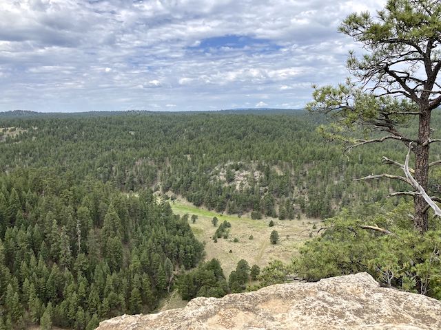
I walked my bike the final 200 yds. to Fisher Point, as it was slightly uphill and easily the rockiest section of my ride. The trail seems to lead naturally east, to overlook Walnut Canyon, but the better view is to the right, overlooking Fay Canyon, Skunk Canyon and Sandys Canyon. I did note that what remained of the Bear Fire was not putting out smoke. After taking photos, I started back.
After I turned right out of the logged parking area, onto FR 301, I saw four bull elk with velvet antlers. Unfortunately, my GoPro battery had run out, and I hadn’t bothered loading my spare. By the time I deployed my iPhone, they were gone. A ¼ mile past the parking area, I turned left onto FR 301D. Since I was (mostly) riding the Flagstaff Loop Trail, my return trip focused on flower photos. 📸
Also avoiding ruts & sand. I couldn’t toodle along FR 301D like I was riding the Peavine & Iron King Trails. I had to pay attention. At least the whole four miles back to Campbell Mesa Trailhead were downhill. At the pasture, I missed the turn to stay on FR 301D, instead staying left on whatever dirt road it is that is on the pasture’s west side.
Directions: From Phoenix, head north on I-17, then east on I-40. Take exit 201, south onto Country Club Dr. In just under a mile, at the driving range, make a left onto Old Walnut Canyon Rd. In just under another mile, opposite the Peaceful Valley Memorial Park religious shrine, turn left into Campbell Mesa Trailhead.
GPS File: Campbell_Mesa_to_Fisher_Point
Distance: 11.56 miles
AEG: 441 ft.
Time: 2h 31m
Biking Video
Biking Flagstaff Loop Trail to Fisher Point from Preston McMurry on Vimeo.