

It has now been three years since the Bighorn Fire, and two years since I last hiked the Catalina Mountains. In 2021, I attempted Butterfly Trail #16, but had to bail after losing the trail in post-fire jungle vegetation near Novio Spring. If I hadn’t had to bail, I would have finished my hike at Butterfly Trailhead.
Today’s plan was to walk Old Mount Lemmon Rd. / Control Road #38 to Crystal Spring Trailhead, then hike all 3½ miles of Crystal Spring Trail #17, finishing up with a 1⅓ mile climb past Butterfly Peak on Butterfly Trail #16 to Butterfly Trailhead. Depending on where I started, I expected the hike to be 7½ miles, 1,700 ft. AEG (accumulated elevation gain). 🦋
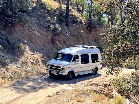
Signs at the top of Old Mount Lemmon Rd. warn that it is “not suitable for passenger cars”. I could have driven my SUV down to Crystal Spring Trailhead, but I did not want my shuttle-driving wife to have to drive back up. So, instead I started at the Mount Lemmon Fire Department — which is only 300 yds. above Oracle Ridge Trailhead.
The steepest part of Old Mount Lemmon Rd. was the 250 yds. down to Oracle Ridge Trailhead, which looks like a borrow pit with a map board. No facilities. From Oracle Ridge Trailhead, Old Mount Lemmon Rd. drops 1,000 ft. in 2¾ miles. Occasionally rocky, with lumpy boulders, it reminded me of FR 172 to Woodbury Trailhead.
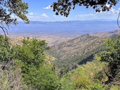
Old Mount Lemmon Rd. was not a problem for walking, though, and had good views south to Westfall Knob and the antenna farm on Mount Bigelow, as well as northeast across the San Pedro River valley, towards the Galiuro Mountains. Brandenburg Mountain, Stanley Butte, Table Mountain and Sombrero Butte were easily identifiable. ⛰
Despite the Bighorn Fire, Old Mount Lemmon Rd. still had some decent shade. There was a good size jeep camping spot just under 1½ miles, and a small one, with rougher access, across from the Crystal Spring Trailhead at just under 3 miles. The only flowers I remember along Old Mount Lemmon Rd. were scarlet penstemon, which I found throughout my hike, regardless of terrain.
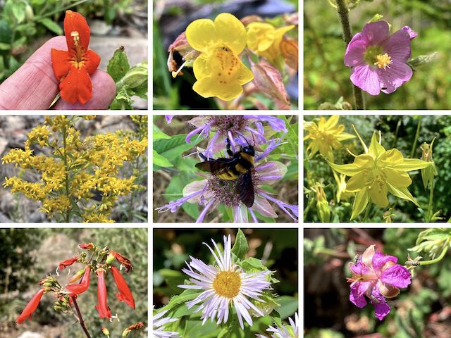
Top Row: crimson monkeyflower, yellow monkeyflower, thicket / Fendler’s globemallow.
Middle Row: Wright’s goldenrod, wild bergamot, yellow columbine.
Bottom Row: scarlet penstemon, spreading fleabane, pineywoods geranium.
Other high country flowers I spotted across Crystal Spring Trail #17 included banana yucca, western yarrow, Arizona thistle, Santa Catalina indian paintbrush, lupine and blooming century plant.
Crystal Spring Trailhead is easy to miss if you are not looking for it, as there is no pullout, just a small sign, which is the same color as the shrubbery. (The mapboard is behind a tree, as is a sign warning about Bighorn Fire-caused flash floods.) The mapboard, and GPS file below, reflect Crystal Spring Trail #17’s current route: Topo maps are off by as much as 300 yds. horizontal and 350 ft. vertical. 🗺
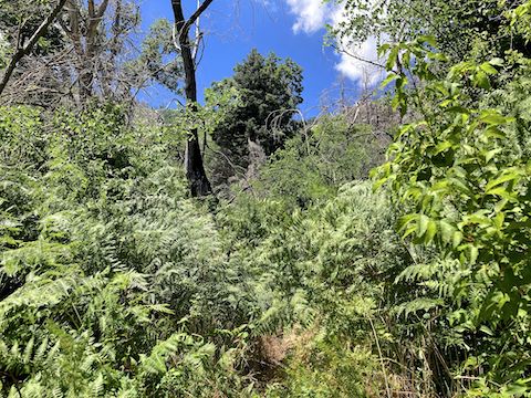
The first mile of Crystal Spring Trail #17 easy to follow through grass & brush. The Bighorn Fire burned quite hot in this area, and little shade remains, except what was provided by the clouds that were starting to roll in. I wasn’t concerned, as the forecast wasn’t expecting rain.
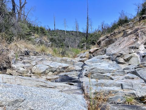
The moisture trapped in the washes raised the humidity, so that by the time Crystal Spring Trail #17 reached the massive boulders above the spring, the trail was overgrown with dense brush. Mostly ferns, some chest-high. Reportedly there is also poison ivy, but I must not be affected by it, as I never got itchy. Just sweaty. The vines with 1″ spikes were never painful or frustrating, like catclaw.
Crystal Spring Trail #17 often became nearly invisible in the brush. I had to concentrate both to pick out the trail, and to avoid stumbling on unseen obstacles underfoot: rocks, branches and tree throw (the holes left by collapsed snags). At least it never got quite as bad as Butterfly Trail #16 near Novio Spring. I saw enough to count seven piles of bear poo. 💩
After 5⅔ miles, Crystal Spring Trail #17 begins climbing, at first through the brush, then clearing as the trail entered an area not burned so severely by the Bighorn Fire. Replacing the joy of brush was rain. At least it cooled the temperature. I endured a 30 minute soaking before finally donning my garbage bag “raincoat”. Thanx weather guys!
Within minutes, it stopped raining. Of course. I didn’t want to take my “raincoat” off, because I knew if I did, it would start raining again. So, I endured the sauna suit, as I slowly way my up the 600 ft. climb around Butterfly Peak. Crystal Spring Trail #17 ends halfway up the climb, so I turned right onto Butterfly Trail #16.
Though Butterfly Trail #16 continues to climb, at the top of the switchbacks there is a “false summit” saddle. I didn’t realize it at the time, but the Butterfly Peak summit is only ¼ mile and 60 AEG to the right (northeast). Butterfly Peak would be a cheap “peak bag” from Butterfly Trailhead. For the most part, there was less brush in the pines. 🌲
Past the “false summit”, Butterfly Trail #16 continues to climb, but at a more moderate angle. I breezed into the Butterfly Trailhead five hours after I started, and sat down at a picnic table with my wife to discuss our day’s, consume a sodium restoring V-8, and enjoy the remains of my breakfast burrito. Best part was, no cramps on the drive back into Tucson!
Directions: From I-10 in Tucson, take Exit 256. Head east on Grant Rd. for 8.5 miles. Turn left onto Tanque Verde Rd. In 3.3 miles, turn left onto the Catalina Highway. In 27.0 very twisty miles (speed limit 35 mph), Butterfly Trailhead is on the right. Continue past it until the road begins turning left into Summerhaven. Instead turn right, then park across the road from the fire department.
GPS File: Crystal_Spring_Trail_17_Catalina_Mountains
Distance: 8.66 miles
AEG: 1,545 ft.
Time: 3h 53m
Hiking Video
Hiking Crystal Spring Trail #17, Catalina Mountains from Preston McMurry on Vimeo.