

There isn’t actually a “Sandys Canyon”. And it usually appears without the apostrophe, despite apparently being posessive. Go figure. 👨🏻🎓
So, what may be referred to — either here or elsewhere — as “Sandys Canyon” is actually the part of Walnut Canyon, between Lower Lake Mary and Fisher Point, two miles of which is traversed by Sandys Canyon Trail #137.
Lower Lake Mary is the more northerly of the two Lake Marys, as Upper Lake Mary is the higher in elevation. Walnut Creek, which is dammed to form the lakes, actually winds north, then east, for 34 miles, before emptying into San Francisco Wash, near Cinder Mountain. Eventually, it all ends up in the Colorado River. Or would, if Walnut Creek had any water. Which it doesn’t. Unless snow- or rainfall is exceptionally heavy. Otherwise, Flagstaff sucks it all out.
There’s several options for hiking Sandys Canyon and Walnut Canyon:
- Sandys Canyon Trail #137: Out & back to Fisher Point is 4.3 miles, 240 AEG (accumulated elevation gain).
- Continue to the Slot Cave: Add 0.5 miles, 0 AEG, out & back.
- Continue until the Walnut Canyon trail peters out: Add another 4.0 miles, 150 AEG, out & back.
- Side trip to the top of Fisher Point: Add 2.2 miles, 460 AEG, out & back. 🏞
I’ve been to the top of Fisher Point before, and it has beautiful views of Walnut Canyon, but this trip I was concentrating on hunting flowers, so I only did the first three options. If you do the whole shot, it is 11.0 miles and 850 AEG. Whatever you do, do not repeat my mistake of hiking Walnut Creek from Lower Lake Mary: It is a rocky & brushy pain in the ass.
From the Sandys Canyon Trailhead, you can see a wood trail sign. Right is towards The Pit and Canyon Vista Campground. (The Pit, aka La Petit Verdon, is a rock climbing area with routes from 5.7 to 5.13c in difficulty.) Unless you want to hang out with elderly RVers, or channel your inner Alex Honnold, turn left.
The Sandys Canyon Trail #137 singletrack heads west along the rim of a small side canyon for 300 yds, before crossing a dry creek bottom. At the trail junction, turn right, heading down the small canyon. The trail descends 150 ft. fairly rocky & rooty feet in only 300 yds. The rest of the way to Fisher Point is basically flat. 👍
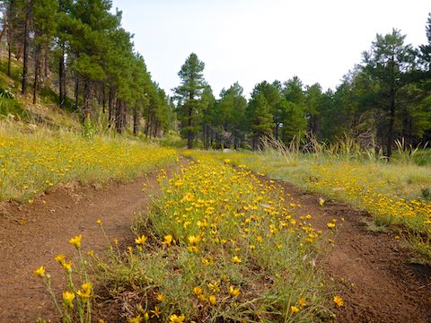
After a ½ mile, Sandys Canyon Trail #137 becomes smooth old jeep trail that heads north along the west side of the pine-dotted canyon bottom prairie. There were dense patches of several different species of yellow flowers along the side, and middle, of the jeep trail. I spotted white prairie aster, pineywoods geranium, spreading fleabane, velvety goldenrod, showy goldeneye, broom-like ragwort, skyrocket, yellow salsify, Wheeler’s thistle and my favorite, violet-blue Lewis flax.
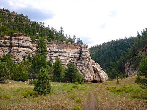
Arizona Trail passage #31 joins from the east at the one mile mark of Sandys Canyon Trail #137. It is nearly another mile to the triangular trail junction apparently known as “Lake Mary Valley”. The Arizona Trail splits west, up Fay Canyon and Skunk Canyon, towards Flagstaff. On the opposite side of Lake Mary Valley is Fisher Point. 📸
While there are nice cliff formations along Sandys Canyon Trail #137, they are mostly on the higher east side, hidden among the pines. From Fisher Point north, Walnut Canyon becomes narrower, deeper & steeper; the cliff photo ops more accessible. A “stay on trail” sign says the now singletrack trail goes for another mile, but I followed it for over two miles.
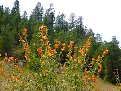
From Fisher Point to where I turned around, the flowers I spotted included sulphur buckwheat, cliff-rose, western yarrow, common sunflower, Mexican elderberry, field bindweed and virgin’s bower. I saw quite a few of a wild yellow-tipped pink flower, each covered in bees, that I later learned is the appropriately named “bee spiderflower”. There were tons of thicket globemallow (aka Fendler’s globemallow) and skyrocket. (One patch of skyrocket was so large, I marked it on the attached GPS route, below.)
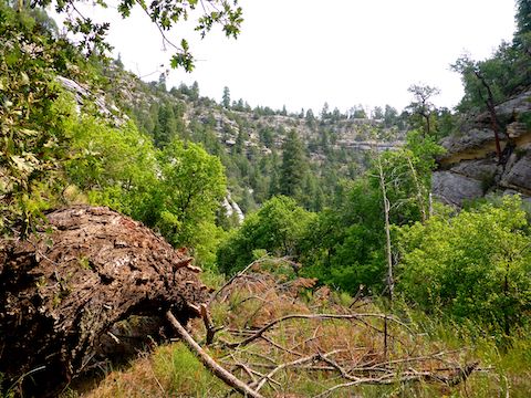
The singletrack through Walnut Canyon is more up & down, but nothing major. Rolling. There are lots of leafy deciduous trees, but also some massively thick pine. Plenty of brush, which the trail avoids. The trail peters out at the (R) symbol on the attached GPS route. 🛰
Finding a cairn, I did pick up the trail for about 150 yds., but lost it again. If you can find the trail, or if you like bushwhacking, you can continue down canyon another ~6 miles to the Walnut Canyon National Monument. I’m not sure what the legalities are, but it is another mile past that to the cliff dwellings, where you can stare up at tourists staring down at you. I turned around.
On the way down Sandys Canyon and Walnut Canyon, my crappy Garmin 62S had kept a fairly accurate track, but on the way back — over the same route — it started going bonkers. At one point, it claimed I was 150 yds. away, up a 300 ft. cliff!
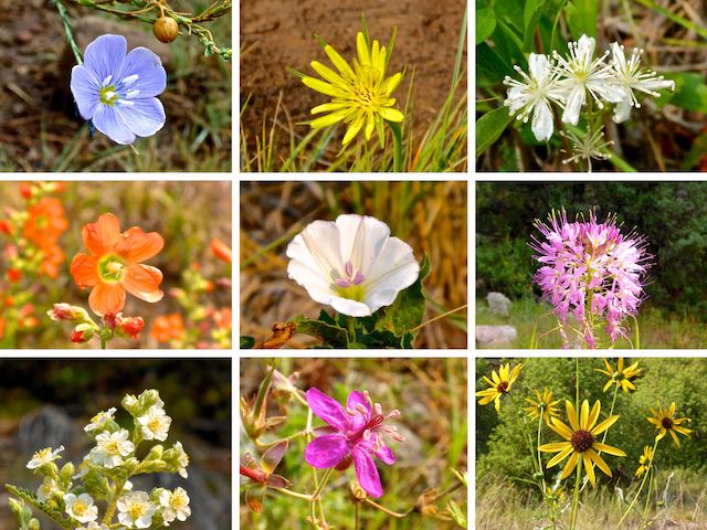
Top Row: Lewis flax, yellow salsify, virgin’s bower.
Middle Row: Fendler’s / thicket globemallow, field bindweed, bee spiderflower.
Bottom Row: cliff-rose, pineywoods geranium, common sunflower.
Directions: From Phoenix, head north on I-17 almost all the way to Flagstaff. When you see the signs for I-40 east, stay right. Take the Lake Mary Rd. exit, which is just before I-40. In 4.6 miles, turn left onto FR 9478Y. Immediately make a right, onto FR 9478X. The Sandys Canyon Trailhead is a ¼ mile ahead. The forest roads are bumpy dirt, but car drivable. There is no parking fee.
GPS File: Sandys_Canyon_Walnut_Canyon
Distance: 9.77 mi.
AEG: 481 ft.
Time: 3h 44m
Hiking Video
Hiking Sandys Canyon & Walnut_Canyon, Arizona from Preston McMurry on Vimeo.