

Two years ago, I hiked middle Miller Canyon, the four miles north of FR 141H. (“Middle” is the section, not the actual name of the canyon.) I have to take Miller Canyon in bite size chunks because it is a 13-mile canyon and a 26-mile round trip is wa-a-ay more than I could chew. No need to repeat my adventure in Willow Springs Canyon a month ago. 👋
Today, my plan was to hike upper Miller Canyon three miles from Rim Rd. at Immigrant Spring to FR 141H, then double back a ¼ mile, before taking some of the jeep trails that parallel the west side of the canyon, about 100 ft. upslope.
Miller Canyon flows downhill, north from the Mogollon Rim at Hi View Point to East Clear Creek, just upstream from C.C. Craigan Reservoir. Miller Canyon is bounded by Miller Ridge, Blazed Ridge, McCarty Ridge and Battleground Ridge.
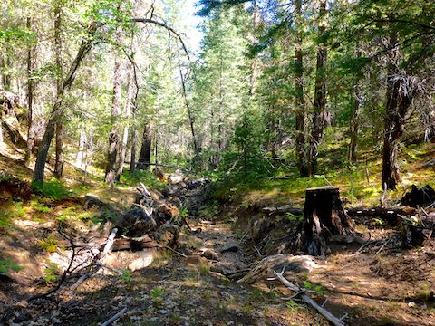
Upper Miller Canyon is 3.5 miles of relatively easy canyon crawling. It is never more than 200 ft. deep. For the most part, it is higher and steeper on the east slope; lower and more moderate on the west. I started my hike, heading west from the trailhead into an intially steep, but short & obstacle-free draw.
In 100 yds., I picked up an obvious old road, that is not on any map. The road petered out in a ¼ mile at a dry tank. Immigrant Spring is 200 yds. past the dry tank, amidst a dense patch of bracken fern, but I could not find it. FR 9366T is on the west side of Immigrant Spring. 🌿
North of Immigrant Spring, upper Miller Canyon immediately becomes slower travel. Not tricky, or obstacle filled, but not a highway either. That would come later. The vegetation was bracken fern and corn lily, with no grab & stabs. The canyon bottom was dry, and there were no flowers.
The first flowers I found in upper Miller Canyon were coneflower, a ½ mile north of Immigrant Spring. I found tons more coneflower the next three miles to FR 141H. Coneflower were by far the most common flower, though there were also plenty of Richardson’s geranium, including some actual patches. (Richardson’s normally occur in ones and twos.)
I’ve found Wildflower Search to be a invaluable tool for identifying flowers: I used it for the New Mexico checkermallow, hoary tansy aster, towering Jacob’s ladder and hairy golden aster IDs below. 🕵🏻♂️
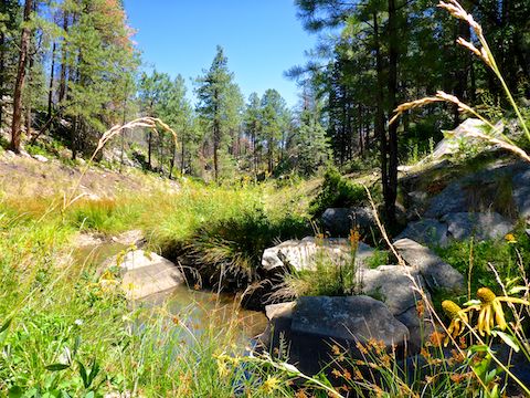
After dodging a few minor obstacles the next ¾ of a mile, upper Miller Canyon opened up quite a bit: Not a prairie, nor a cienega, but grassy & fairly wide, with an animal trail that I followed most of the next two miles to FR 141H. The creek was bone dry most of the day, but halfway across the ½ mile long open area, I began encountering occasional small pools. (No flow.)
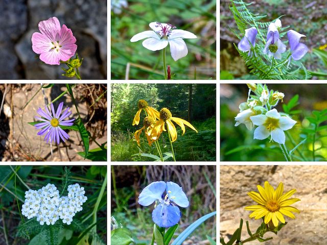
Top Row: New Mexico checkermallow, Richardson’s geranium, Columbian monkshood.
Middle Row: hoary tansy aster, coneflower, towering Jacob’s ladder.
Bottom Row: western yarrow, western dayflower, hairy golden aster.
My favorite part of the upper Miller Canyon open area was a 200 ft. long section of exposed creek bottom slick rock. The slick rock marks two miles from the trailhead.
A ¼ mile after the slick rock, following the game trail, while passing by a dead tree trunk, I ducked my head under a branch … right into a swarm of bees. Holy crap! 🐝
I got out of there quick, but deliberate, being careful not to wave my arms too much, not even normal walking arm swing. I thought I had successfully avoided the swarm, when I came upon the best coneflower patch of the day … where there were more bees. The bee area — marked on the GPS route attached below — is on the east side of upper Miller Canyon, so if I were you, would hike that section on the west side of the creek.
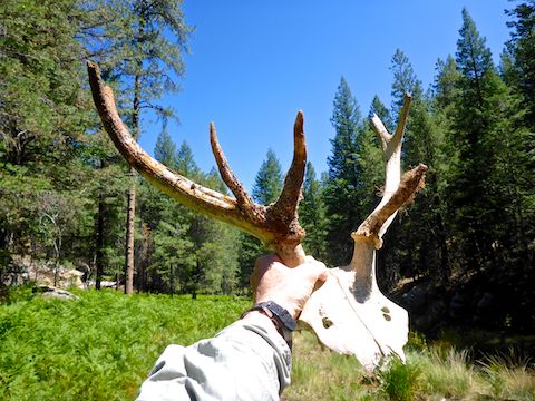
I reached FR 141H at the four mile mark of my upper Miller Canyon hike, or 3½ miles north of Immigrant Spring. I’d been hauling a heavy elk rack with me for the past mile, and it was getting much warmer than I expected. (It was in the low 90s). After eating lunch in the shade, rather than follow the long & winding jeep trails on the west side of the canyon, I instead took my more direct alternate route back to the trailhead.
I walked south, up FR 141H, which climbs 300 ft. in 1½ miles, before levelling out a bit. I was looking for a secure spot to stash the elk rack, but didn’t find an easy to spot, easy to remember, but well hidden, location until I came to the cattle gate where FR 141H intersects FR 320. I hid the elk rack behind a burnt log. 👀
The 1½ miles south on FR 320 back to the trailhead are nearly flat, rising only 80 ft. They are, however, quite rocky, so after rehydrating, I took my time driving back to the cattle gate to pick up my prize.
Directions: From Phoenix, head north on AZ-87, the Beeline Highway, through Payson, Pine and Strawberry. (Alternately, take I-17 north, then AZ-260 east.) 2.6 miles north of AZ-260, turn right onto Rim Rd. / FR 300, which is currently in by far the best shape I’ve ever seen it. In 9.4 miles, just past Hi View Point, turn left onto FR 320. (The sign says “FR 320A”.) Park 100 yds. up, at a campsite. If it is occupied, drive another 200 yds., and park in the large clearing.
GPS File: Upper_Miller_Canyon
Distance: 8.33 mi.
AEG: 538 ft.
Time: 3h 30m
Hiking Video
Hiking Upper Miller Canyon, Mogollon Rim from Preston McMurry on Vimeo.