

The Tonto National Forest is back open, from fire restrictions, but after doing my last three hikes along the Mogollon Rim, I wanted to do something different. Hiking Little Granite Mountain is what I came up with.
There are several options to summit Little Granite Mountain:
- Out & back from Granite Basin Lake: 6.5 miles, 1750 accumulated elevation gain (AEG). ✅
- Loop hike from Granite Basin Lake: 9.0 mi., 2000 AEG.
- Out & back from Iron Springs: 6.0 mi., 1400 AEG.
- Out & back from Division Well: 11.0 mi., 2100 AEG.
Even though temps were expected to be lower in the Prescott National Forest, 90℉ when the mercury peaks at 3:00 p.m. was more than I wanted to take on. So, I opted for the out & back from Granite Basin Lake. My mine exploring buddy Paul, aka Prescottstyle, would be along for the ride.
Paul & I started hiking from the Metate Trailhead, near Granite Basin Lake, at 8:25 a.m. It was a bit confusing at the start, as we first started down a wash marked with blue ribbons, and marked on the topo as “FR 374C”. Then we went past a row of boulders, starting up Granite Mountain Trail #261. Finally, I spotted the Clark Spring Trail #40 sign, on the right side of the trail, rather than on the left where the trail actually goes. Eh. Only lost a few minutes. No big. 🧭
Two hundred yards up Clark Spring Trail #40, Paul spotted the stone tool shed. I’m not sure how old the shed is, but it is old.
From the stone tool shed, Clark Spring Trail #40 climbs 700 ft. in the next two miles. The first mile has spot shade, but is mostly exposed. The next ¾ of a mile, Trail #40 switchbacks through shadey pine, oak and juniper. Two of the juniper — one living, one dead — are massive. (Though not as large as the Granite Mountain Hotshots juniper.) The final ¼ mile to the Granite Mountain Wilderness boundary gate is exposed, as is the rest of the climb to the summit of Little Granite Mountain.
The Clark Spring Trail #40 switchbacks do not do much to slow down mountain bikes bombing down the trail, so keep your head up, and your ears open. Besides two MTBs, we also encountered a couple and their pair of friendly dogs. We chatted with them for a few minutes, and it turned out they were the folks who maintained Trail #40, which they said had been rough and overgrown just a few months ago. Now, the trail is in great shape! 👏
Clark Spring Trail #40 ends at the Granite Mountain Wilderness boundary, where it intersects with Little Granite Mountain Trail #37. A trail sign indicates left is south, 1½ miles down to Iron Springs; right is north, around the west flank of Little Granite Mountain, three miles to Blair Pass. Paul realized one of the bolts was falling out of the trail sign. The washer and nut were still in the back of the sign, so I screwed them back on as tight as I could, squeezing my fat fingertips into the small hole.
We turned north on Little Granite Mountain Trail #37.
From the gate, Little Granite Mountain Trail #37 climbs 100 ft. in a ¼ mile to the top of a spur. If you continue on Trail #37, it descends 700 ft. in 1½ miles to Upper Pasture Trail #38. Instead, at the spur, turn right, off trail up the spur. In 100 yds. is a barb wire fence. I suppose we could have stayed on the east side of the boundary gate, and followed the fence up, but Paul & I did not.
We arrived at the fence just after 10:00 a.m. It was already quite toasty. Paul had been under the impression we were doing the Little Granite Mountain Loop again, not a summit. Combined with the temperature being higher than expected, he was low on water. Rather than cause a heat injury, I suggested we bail. 🥵
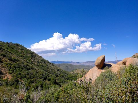
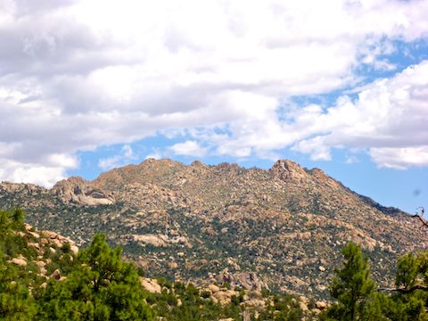
If you continue to Little Granite Mountain’s summit, the next ¼ mile only slightly slopes up. The final ¼ mile, on the other hand, rises an extremely steep 500 ft. (A 37% grade!) There are great views and, supposedly, indian ruins on top.
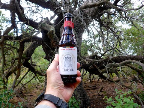
On the way back down, heavy clouds started coming in. The two rain drops I felt were no relief from the heat. It was already 90℉ — heading for 95 at 3:00 p.m. — when Paul & I got back to the Metate Trailhead at noon. Rehydration commenced soon thereafter at La Casa Prescottstyle. 🍻
Directions: From Courthouse Square in Prescott, head north on Montezuma St., which becomes Whipple St. and then Iron Springs Rd. In 4.8 miles, just after leaving Prescott, on the right is Granite Basin Rd. It’s easy to zip by, so be on the look out. Head north for a little over three miles to the one way loop road. Go counterclockwise, past the Granite Basin Lake campground, for a half mile. The Metate Trailhead on the left, by the pit toilet.
GPS File: Little_Granite_Mountain
Distance: 5.83 mi.
AEG: 1,059 ft.
Time: 2h 29m
Hiking Video
Hiking Clark Spring Trail #40, Prescott National Forest from Preston McMurry on Vimeo.