
, barely visible past that small hill in the middle.")
Estrella Mountain Regional Park is 19,840 acres of easy Sonoran Desert hiking. Officially, the most difficult trail is rated “moderate-difficult”, but Maricopa County tends to rate harder than reality. All the climbs are gradual and less than 350 ft.
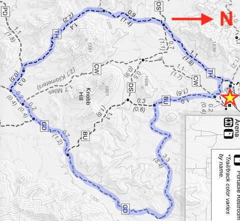
Accounting for terrain, Estrella Mountain Regional Park trails form a rough grid: Rainbow Valley Trail, Toothaker Trail, Coldwater Trail and Butterfield Trail, generally run north-south; Dysart Trail and Gadsden Trail east-west; and Pederson Trail both. Plus, there are some short kid- and oldster-friendly trails near the visitor’s center. That’s why I call this a “locals hike“. 🥾
Last year, I hiked all of Coldwater Trail and Rainbow Valley Trail. Today, I hiked all of Toothaker Trail, most of Gadsden Trail, and a bit of the Butterfield Trail — only 770 ft. accumulated elevation gain (AEG) in 10 rolling miles.
Rather than drive the hell that is rush hour I-17 and I-10, I took the long way around to Goodyear on the Loop 101. It was still pitch black when I arrived at the Waffle House on Dysart Rd. at 6:45 a.m. Which was closed. What the hell? Thankfully, there was an IHOP across the street.
Properly fortified with hash browns and coffee, and the low winter sun having risen, I started hiking from Estrella Mountain Regional Park horse lot / rodeo arena at 8:15 a.m. If you park on the west side of the lot, under the bleachers there is an actual bathroom with flushing toilets & running water. And it was clean! 🚽
From the info / map sign, I went west 50 yds., then turned south onto the Toothaker Trail. After 200 yds. on Toothaker, there is an intersection with Butterfield Trail, which closes the loop. I continued straight on Toothaker, hiking the loop counter-clockwise.
Like any other trail in Maricopa County, you would expect to encounter plenty of other folks: trail runners, dog walkers, horse riders, etc. Other than a steady stream of small planes overhead, I only saw one mountain biker, and he on Toothaker Trail. I was alone the next 3½ hours.
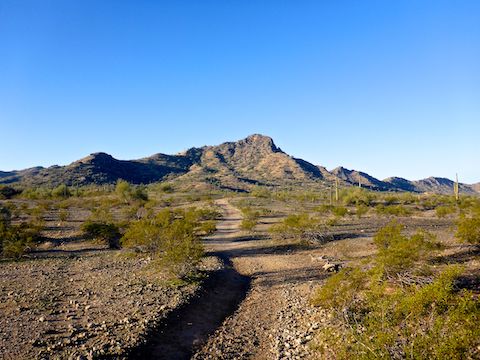
There has been some rerouting along Toothaker Trail, as it heads southwest along the east flank of Hill 1536. The no longer active trail is blocked off by brush and signed “Route Closed” and “Stay On Trails”. Such signs are common in Estrella Mountain Regional Park. 🚫
Toothaker Trail crosses Dysart Trail at 1⅓ miles, and intersects Rainbow Valley Trail at just over two miles. Between the two, Toothaker begins the only climb on this loop, 250 ft. in 1¼ miles. A good part of that, I was back in shadow, and could feel the temperature difference. I caught a nice sunburst at the top of Toothaker Trail (see my hike video, below).
Past the saddle, Toothaker Trail descends 130 easy feet in a mile to Gadsden Trail. I hike the mile of Gadsden between Toothaker Trail and Butterfield Trail, or at least part of it, every time I’ve visited Estrella Mountain Regional Park. That segment of Gadsden is the backbone which ties the park’s longer loops together. 👔
What I haven’t recently hiked is the 3¾ miles of Gadsden Trail east of Butterfield Trail. Eleven years ago, I described Gadsden like this:
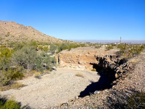
On a 10-mile loop, I was not looking forward to trudging through two miles of sand. Luckily, extensive rerouting has been done on Gadsden Trail, moving it out of the wash bottom, and along shelves or the wash rim. Other than a few wash crossings, Gadsden is now a fast, rolling, MTB track.
At one of the Gadsden Trail wash crossings, I found a large, flat, sitting rock. It was so nice, I took a 15-minute lunch break and marked it on the GPS route attached below.
From the sitting rock, Gadsden Trail descends towards a small knoll on which I thought I saw the ruins of a ranch house. Turns out it was a stone X, rotated 45° from the cardinal points. I think small planes use it as a nav aid, as one flew over while I was taking a whiz. 🙈
The end of Gadsden Trail intersects Butterfield Trail at the base of Knobb Hill. Butterfield is mellow, wide, smooth and downhill ¾ mile to where it crosses the road otherwise known as Coldwater Trail. A ¼ mile later, Butterfield rejoins Toothaker Trail. From there, it’s just a couple of minutes back to the horse lot.
Directions: Head west on I-10 to Exit 126. Then go south on Estrella Parkway for 5.0 miles. Just over the Gila River, turn left onto Vineyard Ave. In a half mile, turn right into the park, onto Casey Abbot Dr. After paying the $7 entrance fee — it helps keep our parks nice! 🙂 — stay on the same road for 2.0 more miles, as it turns south, eventually ending at the rodeo arena.
Park Map: Estrella_Mountain_Regional_Park_Trail_Map
GPS File: Toothaker_Gadsden_Butterfield_Loop
Distance: 10.06 mi.
AEG: 1,023 ft.
Time: 3h 42m
Hike Video
Hiking Toothaker, Gadsden & Butterfield Trail from Preston McMurry on Vimeo.