

After last week’s adventure hiking Willow Springs Canyon, I thought it would be a good idea to avoid canyon crawling, and stick to an established trail.
Since I still wanted shade and elevation, I thought about hiking near Camp Geronimo, at the bottom of the Mogollon Rim, on the east flank of Milk Ranch Point. My last hike out of the Geronimo Trailhead was hiking the Highline Trail to the town of Pine, to celebrate Airborne Day in 2015. 🪂
My intial plan was to hike a clockwise loop of Geronimo Trail #240, East Webber Trail #289, Camp Geronimo’s Rim View Trail, and Highline Trail #31 back to the trailhead. But pre-hike research — should have done that last week! — revealed the Rim View trail is currently severely overgrown & slow going. Yeah, think I’ll skip that. So, instead, I decided to hike Geronimo Trail #240 and East Webber Trail #289 to the source spring of Webber Creek.
As I planned to hike below the Mogollon Rim, my wife & drove up AZ-87, rather than I-17 and AZ-260, which we take when I am hiking on top of the Rim. On the way into Payson there were two mobile electronic signs announcing the Tonto National Forest was closed due to extreme fire threat. The whole thing — which extends from the top edge of the Mogollon Rim 85 miles south to the White Canyon Wilderness, and from close to I-17 70 miles east, all the way to the Fort Apache Reservation. That’s over 2.8 million acres, or nearly 4,500 square miles.
As we continued north out of Payson, every Tonto National Forest road that intersected the highway was gated, coned, or taped closed. Damn. Time for Plan B. 🤔
Luckily, I had a Plan B: Explore Milk Ranch Point, at the top of the Mogollon Rim, in the Coconino National Forest. I didn’t have a route loaded in my GPS, so I figured I would just wing it.
I parked at the intersection of FR 218A and FR 218 (Milk Ranch Point Rd.), on the southwest slope of Baker Butte. From that “trailhead”, I basically walked south along Milk Ranch Point Rd. for almost four miles. FR 218 is in better shape than Rim Rd. / FR 300 usually is. Easily SUV-able as far as I walked it, and even cars would have no problem if it’s dry and they mind their speed.
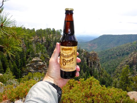
There are informal car camping spots all along Milk Ranch Point Rd., mostly on the east canyon side of the road. But there were a lot fewer fifth wheel RVs than at formal campgrounds, such as nearby Kehl Spring. I think I got passed by two vehicles all day, and they were driving reasonable speeds, not channelling their inner Sebastian Loeb. 👍
Although nowhere near urban levels of garbage, there was more trash than I expected given the low population density along Milk Ranch Point Rd.: Plenty of discarded beer cans, tins of mystery meat, and even rain-bleached toilet paper. But don’t let that dissuade you from a visit!
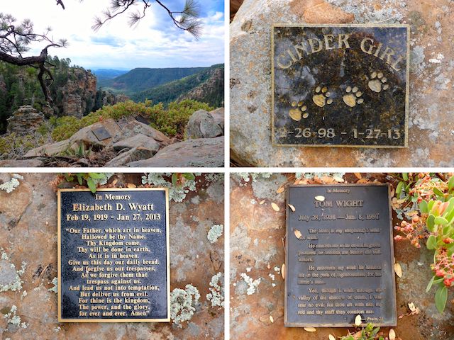
Where West Webber Canyon and Pine Canyon form the “neck” of the Milk Ranch Point mesa, a mile down FR 218, I could see canyon vistas just 500 ft. away. There, I found three brass plaque memorials: Elizabeth D. Wyatt, of Strawberry, who lived be almost 94; her dog Cinder Girl, who passed on the same day; and Tom Wight, about whom I could google no further info. It’s a beautiful spot to spend eternity. 😇
A ½ mile south of the corral is the prairie known as Dickenson Flat. In the middle of the prairie, I saw some white rocks arranged in some sort of design. Crossing the muddy, elk-poo strewn, flat I found that the rocks spelled “PPA” and “PHX -> 75”, with the arrow pointing southwest … towards Sun City. Obviously, some sort of old aerial navigation aid, but whoever followed the arrow would have faced a long, hot, thirsty 18-mile hike across then virgin desert to 1930s Phoenix Sky Harbor Airport. Missed it by that much. 👌
The top of Turkey Springs Trail #217, which heads down to Camp Geronimo, is opposite Dickenson Flat.
The top of West Webber Trail #228 is 3½ miles south on Milk Ranch Point Rd. I walked 200 yds. east on it, but there were no obvious views. It also descends to Camp Geronimo.
A ⅓ of a mile further south, Milk Ranch Point Rd. intersects several forest roads and a trail marked by nothing more than a generic white hiker on brown background sign. (Which turns out to be Donahue Trail #27, down to the town of Pine.) It had started sprinkling 30 minutes before, and by the time I got to the intersection it was raining pretty hard, so I bailed. A few minutes later it stopped raining. 😏
On the way back to the FR 218A trailhead, I did about 2½ miles of mostly very easy off trail hiking. No views, but I wanted to confirm that the interior of Milk Ranch Point was as obstacle free as it appeared from the road.
Hard to believe I hiked over 10 miles, especially given my knees still being achy after last week’s adventure. Next time I explore Milk Ranch Point, I’ll do it from a forward trailhead, probably at the top of West Webber Trail #228, so I can spend more time off trail and still get to enjoy the mesa’s expansive southern views. 🤗
Directions: From Phoenix, head north on AZ-87, the Beeline Highway, through Payson, Pine and Strawberry. (Alternately, take I-17 north, then AZ-260 east.) 2.6 miles north of AZ-260, turn right onto Rim Rd. / FR 300. In 200 yds., where Rim Rd. turns left, instead continue straight onto FR 218A. It’s twisty, and a bit narrow, so mind your speed. It is easily SUV-able, and even a car could make it, if it drives slow. In 1.4 miles, just past the brown Milk Ranch Point sign, is a triangle of forest roads. Park there.
GPS File: Milk_Ranch_Point_20200723
Distance: 10.39 mi.
AEG: 552 ft.
Time: 3h 38m
Hiking Video
Exploring Milk Ranch Point, Arizona from Preston McMurry on Vimeo.