

Middle Leonard Canyon is a four mile long canyon, located on the Mogollon Rim between Hospital Ridge and Knoll Ridge. Middle Leonard Canyon starts on Rim Rd. at Myrtle Point, draining north — as do all top of the Rim canyons — into West Leonard Canyon. A mile east, East Leonard Canyon is dammed to form Knoll Lake. Eventually, all three Leonards empty into East Clear Creek at Leonard Point.
You could make a loop of Middle Leonard Canyon and West Leonard Canyon, but being unsure of how difficult either might be, I decided to stick to my normal routine of hiking down canyon, climbing out, then looping back on a forest road. In this case, FR 300H. (Trying to loop back in another canyon did not work so well in Willow Springs Canyon last year.) I chose wisely. 😉
Due to Middle Leonard Canyon being in the exact middle of the Mogollon Rim, I drove in from the east, to avoid early morning sun in my eyes, and because the Apache-Sitgreaves National Forest section of Rim Road is smoother than the Coconino National Forest Side. Usually: The summer monsoon has roughed up the road and it was foggy anyway.
It was overcast when I started hiking at 8:20 a.m. Rather than canyon crawl Middle Leonard Canyon from the beginning, I hiked FR 9735T for the first mile along the canyon’s east flank. Decommissioned FR 9735T was easy to follow, and had multiple wide puddles. It was obvious the wet forest would be providing many mushroom photos. 🍄
Where FR 9735T turned sharply right, I went left, dropping 50 ft. down into Middle Leonard Canyon.
Typically for the Mogollon Rim, Middle Leonard Canyon had elk bones scattered along its length. (Unlike Upper Miller Canyon, no rack.) There were lots of butterflies: Some, a flat yellow, that would not hold still, and an atlantis fritillary that did me a solid and posed. I also spotted a dead mouse doing the “dying cockroach”. 🪳
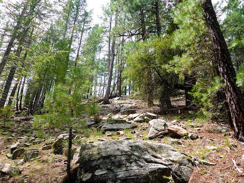
My first mile in the canyon did not seem too congested, yet it took me an hour to hike it. That stretch ended in a ½ mile long meadow, dotted with western dayflower. Then the real fun began …
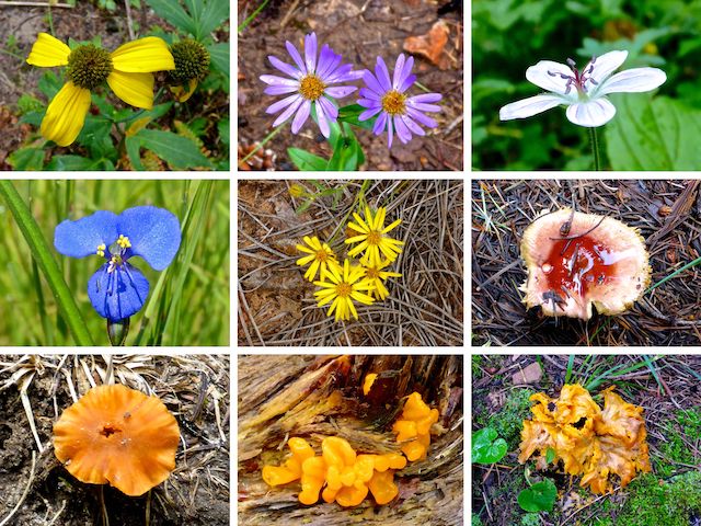
Top Row: coneflower, alpine leafybract aster, Richardson’s geranium.
Middle Row: western dayflower, hairy golden aster, unknown fungi.
Bottom Row: gilled mushroom, orange jelly and, I believe, a more elaborate orange jelly.
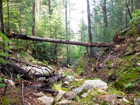
Though never as bad as Crackerbox Canyon, the next 2½ miles of Middle Leonard Canyon to the junction with West Leonard Canyon were even more congested. (Though there were also shelf trails here and there, providing brief respites.) I mean, I could cruise along the canyon rim, or at least far upslope, but when canyon crawling I try to stay as close to the canyon bottom as practicable.
Still, I low-crawled at least five large, downed, pine trees. I took care to avoid being scalped by sharp, broken, branches. Or being pancaked by accidentally jarring a log loose. 🥞
There were many pools of water in Middle Leonard Canyon, below the meadow. The pools ranged from boot sole-deep to calf-deep. The pools often stretched from one side of the narrow canyon to the other. At first, I was able to cross dry, but eventually gave up.
As I hiked further north in Middle Leonard Canyon, I started to keep an eye out for relatively easy bail points, in case I reached an unbreachable obstacle or just got too damn tired. I found three options on the west slope of the canyon, between 3½ and 4½ miles into my hike. I did not climb up them to be sure, but they looked good.
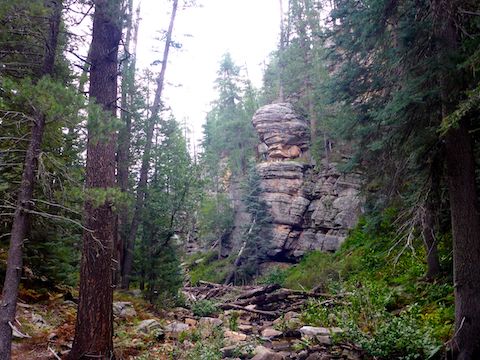
In the midst of that one mile stretch of Middle Leonard Canyon, I found an rocky overhang that would make a pretty good rain shelter. The overhang is not the same as the cave which I’ve heard is in the area. (And which I forgot to look for.) ☔️
I stopped for lunch ⅓ mile after the overhang, at another obstacle. While digging through my pack looking for my QT egg roll, I found some mottled green & black month-old hiking food. I think it may have been a burrito. I really should clean my pack more often.
I’d felt a few random rain sprinkles while eating lunch, but no big deal. They just kinda drifted out of the sky. After that obstacle, Middle Leonard Canyon cleared up a bit. I arrived at the junction with West Leonard Canyon, a ½ mile later, in only 20 minutes. As is usually the case in Mogollon Rim canyons, the spur forming the point of the junction, was steep, but climbable.
The topo map claims FR 300H extends to the top of that Middle Leonard Canyon spur, but no such luck. Still, cross country travel was easy. Six miles into my hike, I found a clearing that was the actual north end of FR 300H. Just past the clearing, I stopped for another snack break. I’d barely had time to sit, before the skies opened up. ⛈
Cutting my break short, I hastily improvised a rain coat from a garbage bag, heading out with a quickness. At least one thunder was pretty close. The worst of the rain lasted 20 minutes. Taking no chances, I covered the 3⅓ miles of FR 300H back to FR 9735T in only an hour and ten minutes.
Directions: From Phoenix, head north on AZ-87, the Beeline Highway, into Payson. Middle Leonard Canyon is dead center on Rim Rd. So, the time from Payson to Middle Leonard Canyon, is the same whether you drive north through Pine and Strawberry, then east on Rim Rd., or if you drive east on AZ-260, then west on Rim Rd. I did the latter, to avoid blinding early morning glare driving east on Rim Rd: Drive east on AZ-260 for 29 miles. After cresting the Mogollon Rim, take the first left onto FR 300 / Rim Rd. In 3.2 miles, at the Woods Canyon Lake intersection, Rim Rd. changes to car-drivable dirt. 9.4 miles from AZ-260 is a t-intersection. Turn left. (Right is FR 34 to Winslow.) In 12.0 miles, a mile past the Knoll Lake turnoff, turn right onto FR 300H. Park as soon as you find a good spot.
GPS File: Middle_Leonard_Canyon
Distance: 10.11 mi.
AEG: 724 ft.
Time: 4h 23m
Hiking Video
Hiking Middle Leonard Canyon, Mogollon Rim from Preston McMurry on Vimeo.