

Originally, I scheduled another Mogollon Rim hike for this week. But I hiked Middle Leonard Canyon last week, and I prefer to avoid hitting the same area too often. I started poking around the topo, and Bear Flat Trail #178, which crosses the north end of the Hellsgate Wilderness between Tonto Creek and Haigler Creek, looked good.
Bear Flat Trail #178 is 8.4 miles end-to-end: Too far for this aging fat man to do an out & back, and too complicated a drive for my wife to meet me at the far end, near Pleasant Valley. In assessing the route, I noticed Horse Mountain is not far off trail, just a 300 ft. bushwhack above Warm Springs Trail #177, which marks the halfway point of Trail #178. 🗺
So, my plan became to hike Bear Flat Trail #178, from Bear Flat Campground to Bear Flat Tank and, if I was feeling good, head out on Warm Springs Trail #177 to summit Horse Mountain. Round trip to Bear Flat Tank is 7.7 miles, 1,700 ft. accumulated elevation gain (AEG); the whole shot to Horse Mountain, 13.0 miles, 2,500 AEG.
Heading east on AZ-260, I missed the turnoff for Ponderosa Campground. I continued up the Mogollon Rim to Rim Top Trailhead, then turned around. If you make the same mistake, take the next exit on the right, at the white-on-green “Thompson Draw One” sign. Both exits will get you to the Bear Flat Campground. (Which is day use only: No overnighting.)
There was one guy fishing in Tonto Creek when I started hiking. The concrete crossing was quite slippery. Just past the crossing, there is a large “No Trespassing” sign. Take a sharp right, along the outside of the wood rail fence. In 50 yds., on the left, is a wood forest service sign for Bear Flat Trail #178. I had to low crawl the barb wire fence, as I could not figure out how to open the gate. 🤔
Bear Flat Trail #178 follows the wood rail fence line for a hundred yards, before turning right, away from the Bear Flat Subdivision. Trail #178 then begins a very steep climb, through shady pine forest. It’s straight up; no switchbacks. The trail surface is pea gravel, so quite slippery, given the angle.
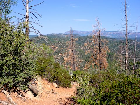
Near the top of the initial climb, Bear Flat Trail #178 enters a very old burn area. There’s still occasional shade, particularly at wash crossings, but for the most part scrub oak, manzanita and juniper predominate. (I saw one manzanita that was — no lie — 10 ft. tall!) Just past the top of the climb, Mescal Ridge Trail #186 is on the right. The sign was missing.
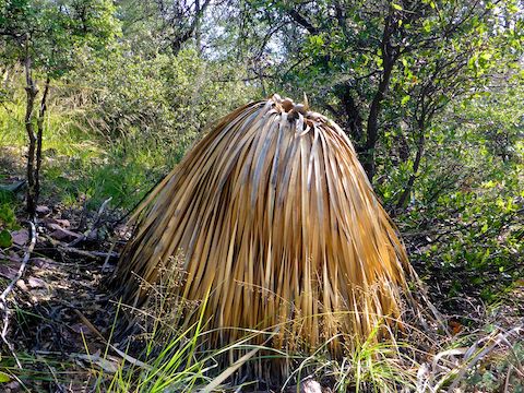
For the next ¾ of a mile, through the north edge of the Hellsgate Wilderness, Bear Flat Trail #178 is single track. Little used, Trail #178 sometimes disappears in the grass. Catclaw often grow in the middle of the trail. The grassy stretch is where most of the flower blooms are found, particularly vervain and, later in the afternoon, New Mexico fanpetals. (A new flower for me.) 🤗
After 1½ miles, Bear Flat Trail #178 exits the Hellsgate Wilderness. Just past the boundary is a small, unnamed, tank with a nice view west, down Bull Tank Canyon. At that tank, Trail #178 changes from single track to ATV trail, which continues at least as far as Bear Flat Tank.
Though the pine growth is not as aged as on the initial climb, the ATV trail portion of Bear Flat Trail #178 does have more shade than the old burn area. And, most importantly, no cat claw. A corral, and another unnamed tank, mark the two mile point of Trail #178.
Almost a mile later, Bear Flat Trail #178 splits: Left climbs to Upper Bull Canyon Tank, so stay right. (I missed the turn on my way back.) A ⅓ of a mile past the split, Trail #178 begins another steep climb with no switchbacks. Thankfully, it is only half the height of the initial climb. 😅
Just past the top of the climb, and before Warm Springs Trail #177, Bear Flat Tank is 100 yds. to the west of Bear Flat Trail #178. Bear Flat Tank is more of a pond, being doted by small lily pads and lined by marsh grass. Deciding a push to the top of Horse Mountain would be unwise — I was sore and behind schedule — I ate lunch before heading back.
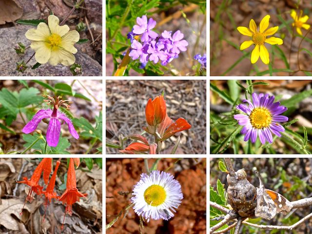
Top Row: New Mexico fanpetals, vervain, showy goldeneye.
Middle Row: pineywoods geranium, paintbrush, hoary tansyaster.
Bottom Row: skyrocket, fleabane and, because I ran out of flowers, a butterfly. 🦋
From the top of the initial climb, I had gnats, flies and mosquitoes buzzing around my head when I was moving, but oddly not when I was still. Not even at Bear Flat Tank. There were also quite a few butterflies. No bears, though there was plenty of bear scat — including one very impressive pile — on Bear Flat Trail #178. 💩
Hiking in Florida, or along the C&O Canal, is basically flat, no matter which direction you are going. But in the mountains, going “downhill” you often go up. (300 ft. in the case of Bear Flat Trail #178.) I took several breaks on my way back down.
The last break I took was just above the steep, pea-gravelled, descent to Tonto Creek. I slipped several times, but with the assistance of much cursing, managed not to fall. Sore though I was, it had been a good day in a new area for me. 🙂
Directions: From Phoenix, head north on AZ-87, the Beeline Highway, into Payson. Drive east on AZ-260 for 13 miles. When you see the white-on-brown Ponderosa Campground sign, turn right. (It is the next exit after Little Green Valley.) Drive straight past the campground, 0.7 miles on rough pavement. At the t-intersection, turn left onto dirt FR 405A. Continue past the “Dead End No Camping or Turn Around Beyond This Point” sign. FR 405A descends 500 steep & twisty feet to Bear Flat Campground, on the right, just before Tonto Creek. Mind your speed, and keep an eye on the look-ahead corner mirrors.
GPS File: Bear_Flat_Trail_178
Distance: 8.79 mi.
AEG: 1,863 ft.
Time: 4h 18m
Hiking Video
Hiking Bear Flat Trail #178, Hellsgate Wilderness from Preston McMurry on Vimeo.