

Hiking Merritt Draw and Maverick Canyon was my eighth, and likely last, Mogollon Rim hike of 2020. It might be a little early yet, even at 7,600 ft. elevation, but I was hoping to find some fall color.
Merritt Draw and Maverick Canyon are located between Dick Hart Ridge and Barbershop Canyon. Bear Canyon and East Bear Canyon, which were my first Mogollon Rim hikes lo these many years ago (2014), are just to the west of Merritt & Maverick. 👴🏻
The head of Merritt Draw is at FR 139 on Dick Hart Ridge. Merritt Draw heads north for 4.5 miles, draining into Barbershop Canyon and, eventually, Clear Creek. Ironically, the canyon is shorter: Maverick Canyon stretching two miles from FR 139 to Merritt Draw. I expected Merritt Draw to be mostly smooth sailing, and Maverick Canyon to be a bushwhack.
There are several options for hiking Maverick Canyon and the upper half of Merritt Draw:
- Merritt Draw In & Out: Along the edge of the prairie to the FR 9735P crossing, or on FR 9735 itself, or both. Anybody could do it! 3.5 miles, 220 AEG (accumulated elevation gain).
- Maverick Canyon In & Out: To the maple grove fall colors. Slightly more difficult, but not hard at all. 2.0 miles, 150 AEG.
- Merritt Draw Loop: Down the canyon’s entire length to the Merritt Draw junction, up the bluff, then backtrack on FR 9733P. 5.0 miles, 500 AEG.
- Maverick Canyon Loop: Past the prairie, bushwhack a mile to the Maverick Canyon junction, up the bluff, then backtrack on FR 9733P. 5.5 miles, 500 AEG.
- Merritt Draw – Maverick Canyon Loop: All of both terrain features. Counter-clockwise, as I did, it is 5.5 miles, 425 AEG. ✅
On the drive up AZ-87, my wife & I hit a construction delay a mile north of Payson. In 10 minutes, no car moved either direction. Thirty more cars had arrived behind us. So, I doubled back into town, then took paved Houston Mesa Rd. to Whispering Pines, then dirt Fire Control Rd. / FR 64 to the town of Pine. The bypass doubled my distance, and halved my speed, but at least my wife & I were moving. 🚧
As I’ve mentioned several times this year, Rim Rd. / FR 300 is in the best shape I’ve ever seen it. Despite being in such good condition, as we passed by Milk Ranch Point, it was obvious there had been even more recent construction, including fresh gravel. At the top of Miller Canyon, we had to stop for another road crew. At least we were the only vehicle waiting, and we enjoyed chatting with the flag guy.
Four hours into a three hour drive, we finally arrived at the head of Merritt Draw, parking at the intersection of FR 139 and FR 9735P. After my hike, rather than repeat the agony of construction delays, we headed east to the end of Rim Rd. / FR 300 — stopping at Woods Canyon Lake along the way — to AZ-260, then back into Payson. It was longer, but took less time, due to no construction.
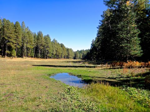
The Merritt Draw – Maverick Canyon loop starts by hiking 300 yds. east on FR 9735P to the second of two small clearings. On the right is the beginning of the Merrit Draw drainage. You may follow the road along the west side of the prairie, or take the easy off trail along the east side of the prairie, as I did. 🚶♂️
There are three “corrals” in the prairie, I assume to protect the vegetation. The corrals are each surrounded by 6 ft. high non-barbed fencing, that used to be electrified:
Corral #1, at Whistling Spring, was 72 paces wide by 214 paces long. (So, about 200 x 600 ft.) Corral #1 contained a small cluster of youthful aspen that had not yet turned.
Corral #2, at Merritt Spring, was 78 x 142 paces. There was some, but not much, water in the drainage below Merritt Spring.
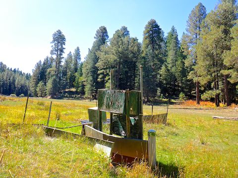
Corral #3, the largest at 78 x 342 paces, has no named spring. There’s a gate at the southwest corner, but I did not open it. On the south edge, there is a small, non-functional, solar panel that used to power the fence. Inside the corral, several trees were individually fenced. Odd. 🤔
After checking out the bird station, I left the prairie, crossing FR 9735P into the tighter part of Merritt Draw. Though it never got really bad, I did feel the effort of low crawling several logs, as I had not hiked the previous two weeks since Medlar Springs. (House issues. Yippee.) There is a goat trail up the west bluff a ½ mile before Maverick Canyon, that looks like it connects to FR 9732P or FR 9709F. There were several small pools of water, but no flow.
At the junction of Merritt Draw and Maverick Canyon, bailing up the bluff did not look difficult at all. On satellite view, Maverick Canyon looked more tangled than Merritt Draw, but from the junction it at least started out okay, so I continued my fall colors search up Maverick.
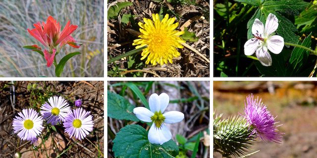
Top Row: paintbrush, dandelion, Richardson’s geranium.
Bottom Row: fleabane, Canada violet, Wheeler’s thistle.
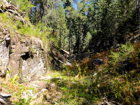
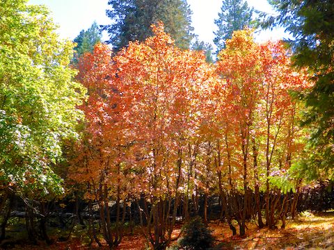
Whereas Merritt Draw was mostly pine (with a few aspen), there was oak, and especially bigtooth maple, on the floor of Maverick Canyon. The first 200 yds. or so, there was some early color high up in the maple, but none yet in the oak. After the maple, Maverick got a bit congested. I side-sloped for maybe a half mile, before it opened back up. From that point back to FR 139, Maverick was smooth sailing, as clear as Merritt Draw had been, but with more golden, fallow, bracken fern. 🍂
A mile up Maverick Canyon, it splits: I went right, and am glad I did. In another half mile, I encountered the grove of bigtooth maple I mentioned in hiking option #2, above. Gorgeous trees full of lime, yellow, orange and crimson. Often mixed amongst each other for bold contrast. I was the best fall color variety I have experienced in 10 years of hiking Arizona! 🤗
Directions: From Phoenix, head north on AZ-87, the Beeline Highway, through Payson, Pine and Strawberry. (Alternately, take I-17 north, then AZ-260 east.) 2.6 miles north of AZ-260, turn right onto Rim Rd. / FR 300, which is currently in by far the best shape I’ve ever seen it. In 12 miles you will cross the Arizona Trail at the Battle of Big Dry Wash monument. In another 4.4 miles, turn left onto FR 139. In 2.4 miles, turn right onto FR 9735P, at the head of Merritt Draw. Park there.
GPS File: Merritt_Draw_Maverick_Canyon
Distance: 6.24 miles
AEG: 453 ft.
Time: 2h 44m
Hiking Video
Hiking Merritt Draw & Maverick Canyon, Fall Color from Preston McMurry on Vimeo.