

The weatherman was predicting it would be 117℉ in Phoenix, near 100℉ in Prescott and Payson — the latter of which is in the closed Tonto National Forest. Even up on the Mogollon Rim — where I was just last week on Milk Ranch Point — the high temp was predicted to be near 90℉ (or 10 higher than normal). Too much. 🥵
But the Mogollon Rim is also the closest (~two hours), highest elevation (~7,600 ft.) hiking destination to Phoenix. So, I looked for a hike I could get to early in the day, and was short, so I could finish by noon, before the temperature peaked at 3 p.m.
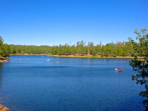
What I came up with is Woods Canyon Lake, which I’ve hiked three times before, most recently in 2017. But a loop around the lake is short, under four miles, so not a good return on my driving investment. Last time, I made it worthwhile by driving a scenic back road to un-scenic Winslow. This time I decided to take a peek down a section of Woods Canyon I never got to two weeks ago, when I tried to hike all the way from Willow Springs Canyon.
My previous Woods Canyon Lake blog contains a good description of the trail’s route, condition & views. I won’t bore you by repeating myself.
Every other time I hiked the Woods Canyon Lake loop I hiked it counterclockwise. Today I hiked it clockwise. Because a trail changes when you hike it the opposite direction, here’s what I noticed that was different:
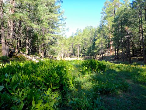
First, there are two dry creek crossings at the west end of Woods Canyon Lake. Hiking clockwise, the southern of the two is Woods Canyon. The obvious, well worn, trail actually continues west, up canyon, through a dense False hellebore (corn lily) patch. It is easy to wander off the “wrong” direction there, so look for the next blue diamond trail marker. 🔷
Second, there were a couple of downed trees across the trail at the west end of Woods Canyon Lake. One log near the second creek crossing was large enough that I could not climb over it. That log is noted on the updated GPS route attached below. The other couple of trees were more easily avoided.
Finally, at a trail split on the north side of Woods Canyon Lake, there was a blue diamond with a black arrow pointing right. I started to go right, but then realized the next blue diamond was to the left. “Somehow”, the arrow sign had fallen off the upper nail, rotating it 180°. I did my best to put it back. Hard to get lost, though, if you always keep the shoreline on the same shoulder. 😉
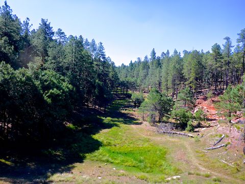
I arrived at Woods Canyon Dam a little over an hour after I started at the bait shop. Looking south, down canyon, I followed a trail from the top of the spillway to the canyon bottom, then across the cienega.
I stuck to the east side of the Woods Canyon, in the shade, as it was already getting warm. The first ½ mile, there was plenty of water in the creek, though the flow was imperceptible. The water often looked greasy, probably engine runoff from the lake. The few flowers were scattered Richardson’s geranium and western yarrow.
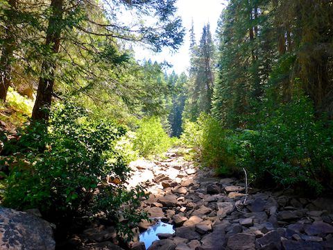
Woods Canyon tightened up after a ½ mile. Strollers will want to turn around at that point, however the trail continues for another ½ mile across scattered boulders, stagnant pools, bracken fern and false hellebore (corn lily) patches. Unlike nearby Willow Springs Canyon two weeks ago, none of the corn lily were blooming.
After a mile, the trail disappeared as Woods Canyon became bouldered up. (Difficult terrain which continues all the way down canyon, five more miles to the junction with Willow Springs Canyon and Chevelon Canyon.) The canyon walls are a climbable 100 ft. bluff; I elected instead to backtrack the trail. ↩️
Once back at Woods Canyon Dam, I followed the shoreline to the baitshop, where my wife was waiting for me with an ice cream drum stick and a hiking beer: A Budweiser, so I’m not sure if she loves me, or was trying to poison me. 🤔
Directions: From Phoenix, head north on AZ-87, the Beeline Highway, to the main intersection in Payson. Head east on AZ-260. Just east of Payson is the hamlet of Star Valley, which once was an infamous speed trap with three speed cameras in only a half mile. That ended in March, 2016, but the speed limit is still 45 mph. In 29 miles, just after AZ-260 tops the Rim, turn left onto FR 300, aka Rim Road. In three miles, turn right onto Woods Canyon Rd., following it to the end at the bait shop. The entire drive is paved, but if you continue west on Rim Road, it is car drivable dirt.
GPS File: Woods_Canyon_Lake
Distance: 5.90 mi.
AEG: 282 ft.
Time: 2h 08m
Hiking Video
Hiking Woods Canyon on Mogollon Rim from Preston McMurry on Vimeo.