

Counter-clockwise from Bronco Trailhead, this is the 3rd segment of the Maricopa Trail.
I’ve had knee problems since I was 20, including blowing out each knee. I never went to a doctor, and was still able to soldier on, even if the knees were unstable for awhile afterwards. Eventually, exercise built muscle which stabilized the knee. So, when my right knee was aching after hiking Black Mesa in December, I didn’t think much of it. I can deal with the ache.
A couple of days after my previous hike in Estrella Mountain Regional Park, I took a walk around my neighborhood. The first mile, no problem. But then my right knee started feeling wonky. The further I went, the more it hurt. By the time I finished the second mile, I could barely walk, it hurt so bad. 😫
Without hiking, I have nothing: Hiking keeps me relatively healthy, relatively sane, and fills my time writing the post-hike blog and editing the video. I have to admit: I was scared.
Long story short, I got my knees x-rayed and my doctor recommended Osteo Bi-Flex Glucosamine Chondroitin pills to maintain cartilage structure, slow cartilage deterioration and hopefully reduce pain. 🙏🏻
I was planning on some elevation hikes this winter, hiking North Mountain to train up for them. But due to my knee, I haven’t done that, and don’t want to push it.
At the same time, having completed my Loop 202 South Mountain Freeway survey hikes a year ago, I was in need of a new local project. I decided to hike the entire Maricopa Trail. But not all at once: I’m not crazy. 🤪
I’ve mentioned before, the Maricopa Trail is 315 miles, but that is the total trail system, including access routes. The actual loop itself, around Phoenix, is about 245 miles.
Since I have already hiked the two Maricopa Trail segments before this one — Bronco Trailhead to Spur Cross and Spur Cross to Cave Creek Regional Park, both counter-clockwise, I decided to hike CCRP to the Anthem Trailhead / Daisy Mountain Fire Department, the same direction.
From the pullout on 32nd St., it is 3.2 miles to the Spear S Ranch Trailhead on New River Rd. From there, it is a further 3.0 miles to the Anthem Trailhead. Both trailheads have info kiosks, hitching posts, and scads of parking, but neither has toilets or water. There are toilets & water at the CCRP visitors center, but that is a 3-mile walk south of the 32nd St. pullout. 👋
A 32nd St. – Spear S Ranch Trailhead out & back, from either trailhead, is 6.5 miles, 760 ft. accumulated elevation gain (AEG). An Anthem Trailhead – Spear S Ranch Trailhead out & back, from either trailhead, is 6.0 miles, 300 AEG. The terrain isn’t exciting enough to justify doing the whole thing out & back.

My wife dropped me off at the 32nd St. pullout, and I started hiking at 9:30 a.m.
The segment begins by heading west on 32nd St. — which has almost no traffic — for 300 yds. to the curved cement barrier. Follow the dirt trail on the right of the barrier for another 300 yds. to a t-intersection. Right is the Maricopa Trail to Spur Cross. Go straight.
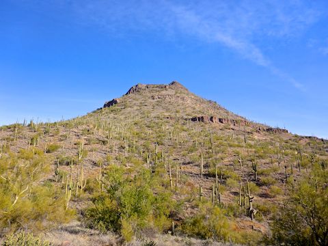
Past the intersection, the Maricopa Trail skirts a ranch property area — complete with loudly barking dogs — for ¾ of a mile, before turning northwest up a small canyon, for the only climb of the day, 150 AEG in a ½ mile. The best views of Apache Peak are along that climb. 📸
From the Apache Peak saddle, the Maricopa Trail follows a contour line west for ¾ of a mile along the north slope of Hill 2875. More ranch properties are to the right, just downslope, in New River. Straight ahead is a very striking, free standing, formation that apparently has no name. Marked Hill 2565 on the topo, you can see it in the hike video thumbnail, below.
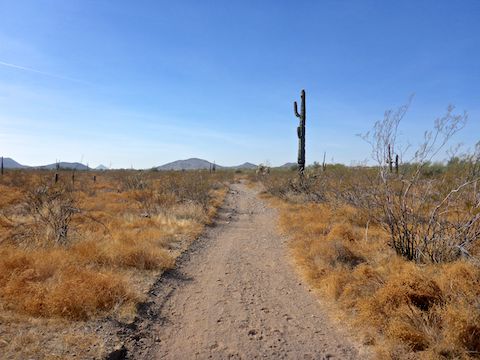
Other than the paved bit of 32nd St., most of this Maricopa Trail segment has been dirt singletrack. The final ¼ mile to the Spear S Ranch Trailhead, and most of the next three miles to the Anthem Trailhead, are instead on decommisioned jeep trail.
Take care crossing paved, 2-lane, New River Rd., as the Maricopa Trail intersects it in the middle of a descending blind curve. 👀
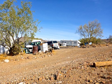
The first mile of the Maricopa Trail west of New River Rd. passes within 100 ft. multiple sketchy properties, littered with debris, boarded up windows, and broken down trailers. Despite the meth-y vibe, no barking dogs.
Halfway into the Spear S Ranch to Anthem Trailhead segment, the Maricopa Trail crosses Rodger Creek for the first of three times. All were dry crossings. Not a spot of water.
The final ¾ of a mile, after the third creek crossing, splits more horse properties to the south (left) and Anthem golf course homes to the north (right). The area is dense with stinknet, aka globe chamomile, an invasive species.
Like the Black Canyon Trail, the Maricopa Trail is open to pedestrians, mountain bikes and horses. I encountered a few dog walkers, but no one else.
Knee held up well, with no crippling pain the next morning. 👍
Directions: Head north on I-17 to exit 223A. Go east on Carefree Highway for 6.0 miles. Turn left on 24th St. In 3.6 miles, turn right on Saddle Mountain Rd. Stay on pavement as the road turns left, then right, becoming 32nd St. Just before the road turns left a second time, park in the pullout on the right.
GPS File: Maricopa_Trail_32nd_St_to_Anthem_TH
Distance: 7.09 mi.
AEG: 454 ft.
Time: 2h 29m
Hike Video
Maricopa Trail: CCRP to Anthem Trailhead from Preston McMurry on Vimeo.