

Unlike two years ago, this Black Mesa Loop actually involved me hiking on Black Mesa, rather than past it on the trail which bears its name.
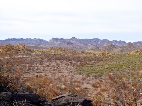
Black Mesa borders the southeast edge of Garden Valley in the Superstition Mountains. It has a prominence of 300 ft. above Garden Valley and the south end of Second Water Creek; 800 ft. above the north end of Second Water Creek. Black Mesa is much steeper on its west side, gradually sloping away to the east. It is 2.0 miles long, with a maximum altitude of 2850 ft., at its south end, opposite Yellow Peak. ⛰
Hiking an out & back to the Black Mesa “summit” from First Water Trailhead is 7.0 miles and 800 ft. AEG (accumulated elevation gain). Meh.
Instead, my plan was to not only hike up to the Black Mesa “summit”, but to traverse the entire Black Mesa ridgeline, then climb Hackberry Mesa, before taking some trails along First Water Creek that I had not been on before. More mileage, more AEG, and two different perspectives on the damage wrecked on Garden Valley by Superstition Fire. 👨🏻🚒
As far as hiking options go, they are nearly endless. But here’s some ideas:
- Hike Dutchman Trail Trail #104 south to Palomino Mountain, then Black Mesa Trail #241 north to the saddle, before getting on the Black Mesa ridgeline. Add about 3½ miles, and 500 AEG, to your hike.
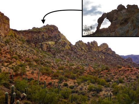
- After hiking the Black Mesa ridgeline, visit the Garden Valley arch. Add about a ½ mile, and 150 AEG, to your hike.
- On the way back to the First Water Trailhead, take a side trip to Hackberry Spring. Add about ¾ of a mile, and 100 AEG, to your hike.
Without the add-ons, the attached GPS route is 7½ miles, 1,000 AEG.
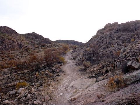
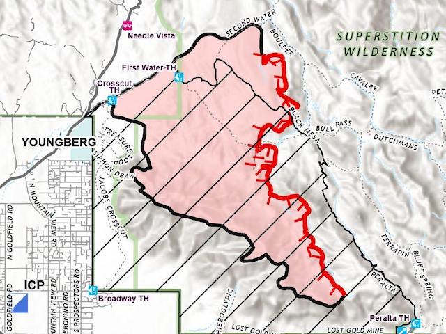
As with nearly all hikes originating at First Water Trailhead, I started off hiking south on Dutchman Trail #104, which the Superstition Fire burned quite thoroughly. In ⅓ of a mile, I split left onto Second Water Trail #236. The trail sign may have been singed, but was otherwise intact.
Second Water Trail #236 crosses two branches of First Water Creek. The area between the branches was devastated. Ironically, the ½ mile climb from the second crossing up to Garden Valley was untouched by the Superstition Fire. That’s the thing I’ve noticed about hiking burn areas: Wildfire tends to skip around. When the Forest Service says a wildfire has burned “x acres”, what they really mean is that the fire’s perimeter contained that many acres, not that all of those acres were destroyed. 🤔
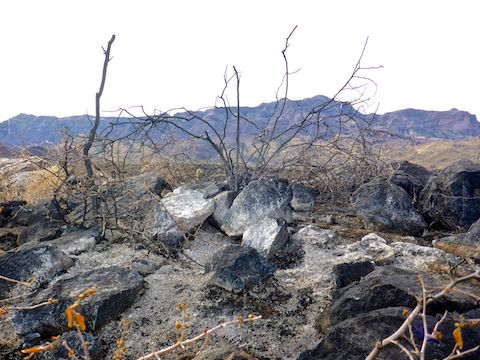
Garden Valley also got hit bad: I saw one large cluster of chain fruit cholla that had nothing left but black stubs. (Chain fruit cholla can grow to to 15 ft. tall and 6 ft. diameter.)
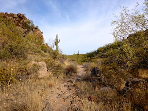
In Garden Valley, I turned south on Black Mesa Trail #241. At the indian pottery spot — not marked on the GPS route 😉 — I found a piece with an interesting rounded edge. Leaving the sherds behind, I continued up the trail to the saddle. The trail is on the unburned east slope of a small canyon. The spur on the opposite slope was obviously where the Superstition Fire burned into Garden Valley.
Near the high point of Black Mesa Trail #241, I made the short off trail climb 100 ft. up to the Black Mesa ridgeline. When hiking, it’s always a good to look behind you: I’m glad I did, because there was an amazing view of Weavers Needle framed by dozens & dozens of surviving saguaro. (See the hike video, below.) 📽
I found it slow going navigating the jumble of boulders on the western edge of Black Mesa; movement was much smoother 100-150 ft. to the east. Black Mesa was one of the last areas to be affected by the Superstition Fire, so damage was particularly spotty. I can say though that two things will survive any fiery apocalypse: cockroaches and catclaw.
I followed the Black Mesa ridgeline north for 1½ miles as it peaked, then gradually descended back to Second Water Trail #236. As I hoped, Black Mesa did indeed have good, relatively high angle, views of the damage in Garden Valley, particularly where the Superstition Fire burned out at the base of Hackberry Mesa. Also nice views northeast, past Tugboat and Geronimo Head to Four Peaks.
I wasn’t too tired yet, but looking up at the rocky approach to Hackberry Mesa, I decided to skip it. I hiked west, back into Garden Valley on Second Water Trail #236: Burn to my left, unburned to my right. (As the above Superstition Fire map shows.) 🗺
I cut a ⅓ of a mile across Garden Valley on a faint trail that may have been from horses, or may have been from fire crews digging line. Near the arch, I picked up the well-travelled, but as yet unnumbered trail that descends towards Hackberry Spring.
After ¾ of a mile, the trail arrives at a saddle. North descends to Hackberry Spring, while south descends more directly to First Water Creek. I went south.
200 yds. south of the Hackberry Spring signs, there is a decrepit old gate. 200 yds. south of the gate-less gate, if you look up and to your left, at the top of the yellow hills, you can just make out the Garden Valley arch. On the slope between the arch and trail were reddish orange swathes from several retardant drops. I didn’t see any Superstition Fire burn damage, so I guess it was in case the fire either burned west over the hills, or north from First Water Ranch.
The slick rock of First Water Creek had several small pools. I walked right over some retardant as I approached First Water Ranch’s windmill, corral and shed. No burn damage along the trail or in the facilities, but climbing up from the ranch along FR 1455 to the First Water Horse Lot was torched. 🔥
I felt okay when I finished my Black Mesa hike, but HOLY COW was my knee stiff & sore that evening. I could barely move the next 48 hours! I think I’ll take it easy with a Shaw Butte hike next week …
Directions: Depending on which part of the Valley you are travelling from, either take the Red Mountain Freeway / Loop 202 or US-60. If you are driving Loop 202 east, take exit 27. Go east on University Dr. for 5.5 miles, then turn left onto Apache Trail / AZ-88 for 5.0 miles. If you are driving US-60 east, take exit 196. Go north on Idaho Rd. for 2.3 miles, then turn right onto Apache Trail / AZ-88 for 5.2 miles. Regardless of which freeway you take, just past Lost Dutchman State Park, turn right onto First Water Rd. The trailhead is at the end of the road in 2.6 bumpy miles. If the First Water Trailhead is full, park a half mile back in the horse lot. Both have pit toilets.
GPS File: Black_Mesa_Garden_Valley_First_Water
Distance: 8.48 mi.
AEG: 1,065 ft.
Time: 3h 58m
Hiking Video
Hiking Black Mesa & Superstition Fire Burn Area from Preston McMurry on Vimeo.