

It gets cold in 7,000+ ft. northern Arizona during winter: The record low is a shocking -40℉ at Hawley Lake, in the White Mountains, on Jan. 7, 1971. Heck, last year, Bellemont, where I used to work in the woods just west of Flagstaff, hit -13.
So, I spend late fall and winter hiking closer to Phoenix. The coldest I can remember hiking in Phoenix was 32℉ at South Mountain in 2017. The coldest I’ve seen in the low desert was 27℉ in the Butler Valley, south of Alamo Lake: There was even snow on the ground. 🥶
The coldest I’ve actually hiked in, was 30℉ on the South Mountain in Maryland, while hiking the Appalachian Trail, and again in St. Vith, Belgium (where it was -1℃ at the local bank). In the latter case, I didn’t even have a windbreaker and, to compound the fun, it sleeted. St. Vith, that late May morning, was officially the coldest place in Europe — even colder than Norway!
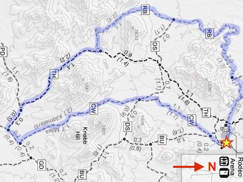
It is ironic, then, that it was 34℉ today when I planned to hike Coldwater Trail in Estrella Mountain Regional Park. I’d been on Coldwater twice before, inbound, so today I would head out on it, go a ¼ mile west on Gadsden Trail, then 1.6 miles north on Toothaker Trail, before looping 4.2 miles back to the rodeo arena on Rainbow Valley Trail.
The Coldwater – Gadsden – Toothaker – Rainbow Valley loop is 9.2 miles, 950 AEG (accumulated elevation gain). A shorter option would be to cut across the middle of the loop on Dysart Trail, for a 5.6 mile, 470 AEG hike. Both options are on the GPS file attached below. 🛰
Because it was New Year’s Day, “rush hour” traffic was very light, so I cruised west on Indian School Rd. to Avondale. I only saved one dashcam capture, and I think he may have been a late drunk. As it was still dark, I stopped for hashbrowns, biscuits & gravy at Waffle House. 🤗
I started hiking from Estrella Mountain Regional Park’s rodeo arena at 8:30 a.m.
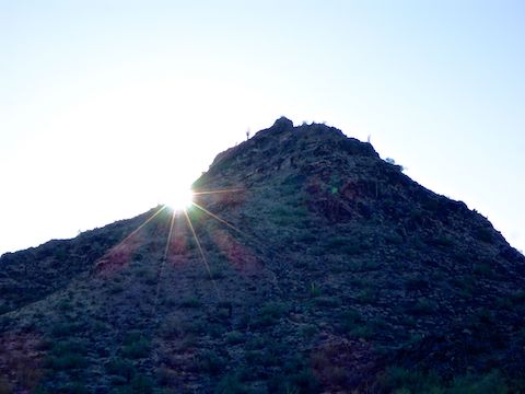
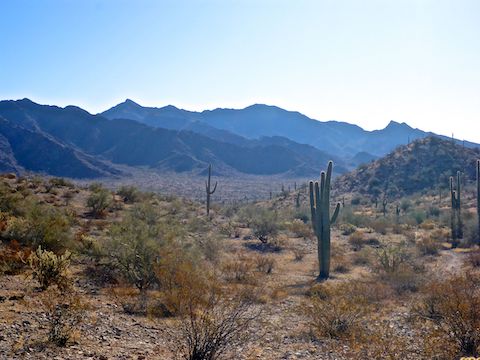
I headed past the tube steel vehicle gate, south on Coldwater Trail (the wide gravel road). In a mile, there is a secondary horse lot. Coldwater crosses Dysart Trail a ¼ mile past the red reflective diamonds. There is a memorial rest bench at the Dysart intersection. Coldwater Trail continues to narrow as it climbs 220 ft. in the next mile to a saddle on the southwest slope of Knobb Hill. The saddle has good views south into the heart of the Sierra Estrella. ⛰
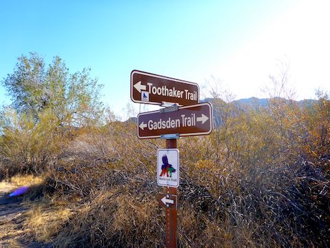
From the Knobb Hill saddle, Coldwater Trail descends 100 ft. in ¾ of a mile to the Gadsden Trail intersection. Turn right (west) on Gadsden Trail for only a ¼ mile to the Toothaker Trail intersection.
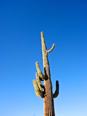
Toothaker Trail climbs 240 ft. in a mile to another saddle. Estrella Mountain Regional Park, especially in cold months, does not have a lot of photo ops, other than saguaro. (No flowers.) As a result, I was rolling tape for my hiking video, because as a “slide show” it would have been less than a minute long. So, I took a break on the Toothaker saddle to record voiceover bits to make the end result more interesting. Also, the temperature was finally tolerable to where I could remove my hoodie and woolie cap.
Toothaker Trail descends 180 ft. in ¾ of a mile to the Rainbow Valley Trail intersection. (On my hiking video, I misname it “Rainbow Trail.”) It was nearly 11:00 a.m. when I turned onto Rainbow Valley Trail, so I started seeing other hikers — presumably without hangovers — on a regular basis. 🥳
Rainbow Valley Trail climbs 180 ft. in a ½ mile to the top of a spur with good sitting rocks. The final four miles back to the rodeo arena are almost all downhill, or level along contour lines.
Heading north, the Rainbow Valley Trail crosses multiple small washes. There’s some nice houses on big lots, a half mile west on the Estrella Mountain Regional Park boundary. The large white buildings a couple of miles north include an Amazon distribution center. Goodyear Airport, with its rows of condemned jumbo jets, is also visible. ✈️
The west end of Dysart Trail intersects Rainbow Valley Trail a mile north of the saddle. Just past Dysart, I went off trail in one of the larger washes for pee break privacy, a snack, and to record more voiceovers. Plus, the wash had shade, which is otherwise in short supply in Estrella Mountain Regional Park.
I thought Rainbow Valley Trail was shorter than it actually is, so it seemed to drag on forever. With two miles to go, it turns east, squiggling along the north slope of Hill 1536. An old tank and hardstand are just 250 yds. north, and past that the Tres Rios Golf Course. The Estrella Mountain Regional Park nature center, hidden behind another hill, is connected to Rainbow Valley Trail by a web of more kid- and oldster-friendly trails, such as Quail Trail, Baseline Trail and Horseshoe Trail.
The final mile of Rainbow Valley Trail was a steady stream of people and dogs, making it hard to tape video without looking like a douche.
I took a short break at a picnic table after I finished. Instead of a hiking beer, my refreshment was a V-8: No sense in tempting any cops on the ride home who might still be monitoring the New Year’s chaos … 😉
Directions: Head west on I-10 to Exit 126. Then go south on Estrella Parkway for 5.0 miles. Just over the Gila River, turn left onto Vineyard Ave. In a half mile, turn right into the park, onto Casey Abbot Dr. After paying the $7 entrance fee — it helps keep our parks nice! 🙂 — stay on the same road for 2.0 more miles, as it turns south, eventually ending at the rodeo arena.
Park Map: Estrella_Mountain_Regional_Park_Trail_Map
GPS File: Coldwater_Toothaker_Rainbow_Valley_Loop
Distance: 10.06 mi.
AEG: 1,023 ft.
Time: 3h 42m
Hike Video
Hiking Estrella Mountain Regional Park from Preston McMurry on Vimeo.