

I haven’t gotten out of the house for anything more than a spin around the neighborhood since biking the Maricopa Trail three weeks ago. Funeral one week, sick the next. And then my bike got another flat. (Thankfully, not requiring a five mile push like the Pemberton Trail!)
Despite the temperature being unseasonably warm, it felt good to get my feet back on dirt. Today, in the Phoenix Sonoran Preserve, which is located in far north Phoenix between Cave Buttes Dam and Cave Creek Regional Park. The Preserve has two units, South and North, separated by Dove Valley Rd.
My hike was in the south unit, from the Hawk’s Nest Trailhead, near the Fireside at Norterra community center. Other than Bobcat Trail at the north end of Dixie Mountain Loop, Hawk’s Nest Trailhead is the only public access to the south unit’s trail system. 🅿️
- Western Vista Out & Back: It is 4.0 miles, 900 ft. accumulated elevation gain (AEG) to the top of Western Vista.
- Dixie Summit Out & Back: More isolated than Western Vista. Not as long, nor as high, but with a steeper summit push (3.2 miles, 640 AEG).
- Dixie Mountain Loop: Skipping the two summits still results in some good cardio (4.6 miles, 750 AEG).
- ✅ Loop & Both Summits: The whole deal totals 5.8 miles, 1,275 AEG.
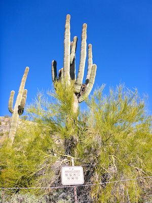
After picking up my bike from the shop as soon as they opened their doors at nine, and a murderwich from the Stop’n’Rob, I drove up to the Phoenix Sonoran Preserve. The roads around Fireside at Norterra always confuse me, but for the first time, I didn’t make a wrong turn, either coming or going. ![]()
Hawk’s Nest Trail climbs a bit over 200 ft. in just under a ½ mile between the trailhead and Dixie Mountain Loop. It’s steep enough I saw a mountain biker pushing his MTB uphill. The creosote along Hawk’s Nest Trail, were particularly dense with yellow flowers.
In addition to the creosote, there were plenty of blue dick and miniscule fiddleneck; scattered small desert chicory, a few annual wall rocket, and some desert globemallow on the Dixie Mountain summit. Mexican gold poppy — which like a little more heat — bloomed later in the morning, and were smaller than normal. There were no cactus flowers to speak of.
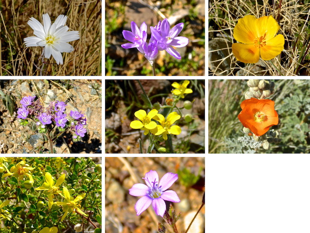
Top Row: desert chicory, blue dick, Mexican gold poppy.
Middle Row: scorpionweed, annual wall rocket, desert globemallow.
Bottom Row: creosote and something I can’t find on wildflowersearch.org.
Dixie Mountain Loop rises 50 ft. in a short distance from Hawk’s Nest Trail, to a saddle, before quickly descending 200 ft. to a housing area. (I hiked clockwise.) Just after the trail turns east, along a wash, there is a rusted out car full of bullet holes. I told another hiker that the little canyon behind my house has three wrecks, including a milk truck.
After crossing the wash, Dixie Mountain Loop rises 100 ft. in a ¼ mile, along the east slope of Western Vista. The cholla, particularly jumping cholla, are at their thickest there. But Dixie Mountain Loop is wide enough that unless two mountain bikes are passing each other, no worries. The trail surface is also decent enough that you can usually hike without tripping concerns. 👍
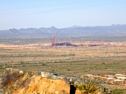
Western Vista Trail is fairly wide, and gravelly to slightly rocky. It rises 315 ft. in ⅓ mile, with a short less-steep section for cardio relief. There’s enough shrubbery on the Western Vista summit that I was able to enjoy my murderwich without getting too burnt. The scenery is not great — lots of concrete things — but it is vast.
Back on the Dixie Mountain Loop, the trail descends 100 ft. in ¼ mile to the Bobcat Trail junction. There’s plenty of directional trail signs along each of the Phoenix Sonoran Preserve’s trails. Not just at the intersections. Each sign is a color-coded sticker on a rusty pole. Each sticker has a smart phone-scannable QR code, elevation profile, trail name & distance. Note that a trail’s color code on the park map, and on the sign pole, do not necessarily match. 🤔
From the Bobcat Trail junction, Dixie Mountain Loop turns southeast towards its namesake, climbing 400 ft. in 1⅓ miles to the Dixie Summit Trail junction. This is the most isolated part of the hike, and I was disappointed not to encounter the western diamondback I was warned was ahead of me.
Dixie Summit Trail is rocky, twisty, no-MTB singletrack. Despite being narrow, it is grab & stab-free. I took a shade-less break on top, finishing off my lunch, wishing I still had that beer. Dixie Mountain has 360° views — you can see over the top of Western Vista — including Piestewa Peak, Thompson Peak, Four Peaks (directly behind Tom’s Thumb), Elephant Mountain and New River Mesa.
Back on Dixie Mountain Loop again, and my videography complete, I hauled 1⅓ miles back to Hawk’s Nest Trailhead in only 28 minutes.
Directions: Head north out of Phoenix on I-17 / Black Canyon Freeway. Take exit 219 east onto Jomax Rd. In a mile, turn left onto 19th Ave. / North Valley Pkwy. In a mile, turn right onto Copperhead Trail. Take the second left onto Melvern Trail. Just past the community center, turn right onto Desert Vista Trail, which ends at the Desert Vista Trailhead in ⅓ mile.
Park Map: Phoenix Sonoran Preserve Park Map (pdf)
GPS File: Dixie_Mountain_Loop
Distance: 6.31 mi.
AEG: 1,312 ft.
Time: 2h 30m
Hike Video
Dixie Mountain Loop, Phoenix Sonoran Preserve from Preston McMurry on Vimeo.