

Counter-clockwise from Bronco Trailhead, this is the 6th segment of the Maricopa Trail.
My goal is to hike or bike all 245 miles of the Maricopa Trail, which encircles the Phoenix metro area, aka The Valley of the Sun. I am doing one segment per month, from late fall to early spring, when temperatures are less than the surface of the Sun. ☀️
With 90-100 miles of the Maricopa Trail being canals or even city streets, including much of Lake Pleasant to 119th Ave., today was my first biking segment. Because biking isn’t conducive to taking photographs, I bought a GoPro HERO10 Black, which I’ve been testing on neighborhood rides.
If you don’t have a shuttle driver, as I did, or are actually hiking, hike out & back from the Agua Fria Trailhead to Lake Pleasant Parkway, which is 9.1 miles, 430 AEG (accumulated elevation gain). The southern ⅔ of the segment to 119th Ave. are either for locals, or not worth it.
I’m a completist though, so I did the whole thing.
From the Agua Fria Trailhead, head east further along Beardsley CSR Rd. In 150 yds., after crossing over the bridge, turn right onto the decent gravel road. In ¼ mile, pass under the Carefree Highway. Just past the bridge, split left onto a rougher road, and in 100 yds. turn left onto the single track. All these turns are marked by Maricopa Trail logo signs. ![]()
The single track twists uphill, 100 ft. in ¼ mile. Like most of the next four miles, it is quite rocky. Okay for hiking, but too steep & slippery for this old man to pedal up. I walked it. At the top of the rise, the single track passes through a small cholla forest, then turns south, paralleling the Waddell Canal.
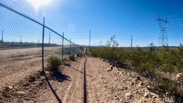
The Waddell Canal, with a smooth service road, is on the other side of cyclone fencing, The Maricopa Trail is on portions of the old, rocky, service road. There are several short, steep, twisty dips where the trail crosses culverts. Those I hiked as well. I figure I walked a mile altogether.
Some of the later dips I was able to get down & up while riding, as the Maricopa Trail was straight, so I could maintain momentum — of which my fat ass generates a fair amount. 😏
As on the previous segment between FCI Phoenix and Lake Pleasant, the Maricopa Trail passes under multiple high-tension powerlines. Only one set of powerlines was humming, and not nearly as loud as the ones next to New River Rd. For some reason, my biceps were getting really sore from the rocky bouncing.
At the three mile mark, the Maricopa Trail crosses a paved road. To the left, on the east side of Waddell Canal, is Pleasant Valley Airport. I didn’t see any of the ultralights or gliders based out of there. Downslope, to the right is Canyon Speedway. Nearby, I spooked a trio of wild burros.
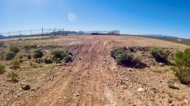
After crossing the paved road, the Maricopa Trail gets less rocky the next mile to where Waddell Canal merges with the Central Arizona Project CAP Canal. Immediately after the CAP Canal, turn left on the service road towards Lake Pleasant Parkway. There’s a vehicle gate dead ahead. I say “dead”, because if a biker isn’t paying attention, it will take his head off. 😵
At Lake Pleasant Parkway, the Maricopa Trail turns right along single track just a few yards from the road. If you’ve developed a flat, you can get a pickup at any of the several pullouts in the ½ mile between the CAP Canal and the Loop 303 Freeway. (Take the sidewalk across.)
On the south side of the Loop 303 Freeway, the Maricopa Trail becomes a wide, packed, sand path for the next 2½ miles. A mile south of the freeway, on the left side of Lake Pleasant Parkway, is the entrance drive to Paloma Park. (With water and toilets.) Not quite a half mile past Paloma Park, on the Maricopa Trail side of the road, is a shady cabana. I took a 20 minute break there.
After 7½ miles, the Maricopa Trail enters civilization (houses, businesses, etc.). ⅓ mile south of Westwing Pkwy., the trail surface changes from hardpack to cement sidewalk. At 8½ miles, turn right on Jomax Rd. In ¾ mile, the road bends left, dropping quickly. I hit my high speed of the day, 26 mph, on the descent. 🚴🏻♂️💨
At the bottom of the hill, curve right. At the edge of the housing area, turn left across the quarry access road. The next ¾ of a mile to Pleasant Valley Pkwy. you have a choice of adjacent blacktop or hardpack paths. There’s nice houses to the left, and the Agua Fria River bottom to the right.
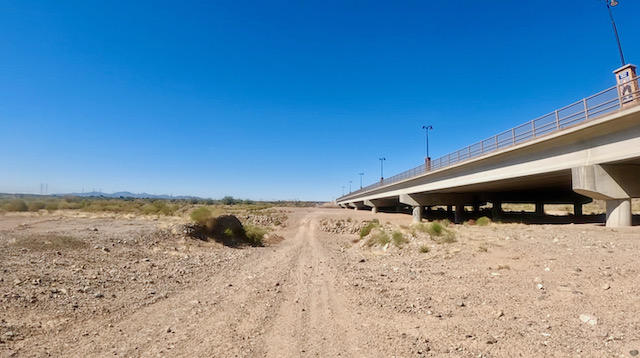
After passing under the bridge, the Maricopa Trail turns right, a ½ mile across the dry Agua Fria River. On the west side of the river, head right, off the jeep trail, up to the sidewalk. Traffic is heavy the next ¾ of a mile to the Loop 303 Freeway (again), so take care at the traffic lights and on/off ramps.
On the west side of the Loop 303 Freeway, the sidewalk ends. Head slightly up & left, onto dirt, for the final ¼ mile to 119th Ave. The “trailhead” is a vacant lot.
Agua Fria TH Directions: From Phoenix, head north on I-17. Take exit 223B onto Carefree Highway / AZ-74. Drive west for 9.1 miles. By Lake Pleasant, at the bottom of the hill, just after you cross the second bridge, turn right onto Beardsley CSR Rd. The Agua Fria Trailhead is 0.3 miles straight ahead, on the left.
119th Ave. TH Directions: From Phoenix, head north on I-17. Take exit 218 onto Happy Valley Rd. Lake Pleasant Parkway is in 9.0 miles. (If you are instead heading south from the Agua Fria Trailhead, turn right here.) In another 2.5 miles, 119th Ave. is the first left after passing under the Loop 303 Freeway. Park in the vacant lot on the corner.
GPS File: Maricopa_Trail_Lake_Pleasant_to_119th_Ave
Distance: 11.97 mi.
AEG: 336 ft.
Time: 1h 53m
Bike Video
Maricopa Trail: Lake Pleasant to 119th Ave. from Preston McMurry on Vimeo.