

Heading east from Dewey, this is the second part of the 6th segment of General Crook Trail.
The overall sixth segment of the General Crook Trail, from Baker Lake (V33) to General Springs Cabin, is only 10 miles. But because I wander and backtrack, my hikes tend to be 20-25% longer than expected. So, I broke it up into two subsegments: Baker Lake to Kehl Spring Campground and, today, six miles from Kehl Spring (V39) to General Springs Cabin (V43). 🏚
In 1871, General George Crook surveyed a supply road west from Fort Apache, Arizona, across the Mogollon Rim to Camp Verde, then on to Fort Whipple in Prescott. The General Crook Road was built in 1872. The Army used the road until 1896, and civilians until 1928, when Rim Road replaced it.
No General Crook Trail resource agrees on the exact route followed by his troops: There’s one map that shows two crisscrossing routes! I’ve given up trying to choose between them. It’s just too confusing. From now on, I am following the chevrons nailed into trees by the Boy Scouts in 1976. (The Scouts also planted mileage posts every mile.)
I started hiking at 8:30 a.m. I headed out of the Kehl Spring Campground, turning left (east) on Rim Road. In ¼ mile, there is a pullout on the left, that you can park in if you don’t want to pay the campground’s $8 day use fee. Opposite the yellow twisty road sign, is a tree with a chevron, and what looks like it may be old wagon road. Follow it, looking for further chevrons. 👀
The General Crook Trail roughly parallels Rim Road, which is maybe 100 yds. to the right. The trail soon disappears in an old burn area, tangled with slash and wild raspberry. Not for the last time, the chevrons also disappeared. I picked my way through the path of least resistance, until I hit a trio of chevrons in quick succession just before FR 141.
I turned left, back onto Rim Road, following chevrons for 250 yds. Just past the yellow “sharp curves-next 2 miles” signs, are two chevrons, seeming to indicate the General Crook Trail heads off road to the right. I went that way, except it was even more tangled, and comes back to Rim Road in 200 yds. anyway. Not worth it. Rim Road then leaves the forest, entering exposed old burn area for the next 3¾ miles.
At the one mile mark, just past the intersection with FR 300J and FR 300K, I followed a chevron right, off Rim Road, onto what seemed to be General Crook Trail. The route was ferns and grass, crossed by small logs. The trail seemed to peter out after ¼ mile, so I got back on Rim Rd. Looking at the route on satellite view, I think it is actually the flat upper reaches of a wash that drops over the Mogollon Rim.
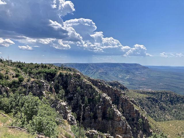
At the 1½ mile mark, The_Eagle‘s route cut a sharp Rim Road corner, off General Crook Trail. I followed it just to get my feet on ungroomed terrain. You should follow the road instead. In fact, I recommend staying on Rim Road from FR 141 until you are ⅓ mile past FR 501. It may not make for the most exciting hiking, however you can’t beat the views. There are multiple fantastic observation points. You will move much quicker and, when you want to take time, you can take it all in and enjoy it. 🤗
At the 1¾ mile mark, following The_Eagle’s route, I split left off Rim Road, which never got more than 100 ft. away. I passed by a road-adjacent General Crook Trail sign — like the one back at Baker Butte — before losing the trail in small sea of ferns. Enough of that! I walked Rim Road for the next two miles.
At the 3½ mile mark, General Crook Trail / Rim Road re-enters the forest, crossing a cattle grate at FR 501. Chevrons again led me off the road, but at least the 200 yds. was smooth sailing.
Remember when I said this is a longer hike than indicated? Starting at mile marker V39, and hiking just under four miles, mile marker V43 — or at least General Springs Cabin — should be in sight. Not so. But to the left is a chevron leading to what appears to be old wagon road. Though General Crook Trail crosses Rim Road twice in the next half mile, it was the most pleasant, shady, part of today’s hike.
At the end of that half mile, General Crook Trail turns left (north) on FR 123.
You can hike the General Crook Trail for quite awhile without seeing a chevron or mile marker. And I was looking. Often standing in one place, and slowly scanning. I think many of the trail markers the Boy Scouts placed in 1976 have since been logged, burnt in wildfires, or plowed over while widening Rim Road. At least there were chevrons along FR 123.
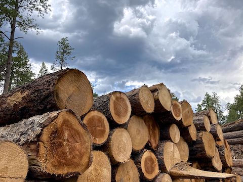
Just past the cold deck, General Crook Trail takes a sharp right turn, which is marked by a chevron that points sideways. That’s the first time I recall a directional blaze on this trail. I did my scanning thing, but saw no further blazes as I passed through the logging slash, down to FR 705 / Pipeline Road. I was about 250 yds. off The_Eagle’s route. FR 705 is very rocky.
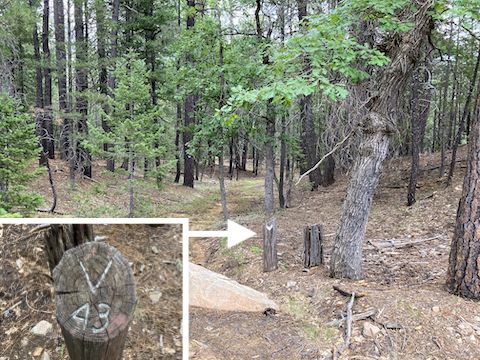
A ¼ mile south on FR 705, I finally found a chevron on the right, uphill, FR 123 side. To the left, also with a chevron, was mile marker 43. There was an obvious trail there, so I followed General Crook Trail for about 300 yds., until it reconnected to FR 705 at General Springs Cabin.
My wife was waiting for me at General Springs Cabin, where she was having a good talk with Deena and her friendly pup. Deena was camping there while her husbad Steve, and other Arizona Trail volunteers, were somewhere up General Springs Canyon and Battleground Ridge doing trail maintenance. And still, it hadn’t rained.
Kehl Spring Campground Directions: From Phoenix, head north on AZ-87, the Beeline Highway, through Payson, Pine and Strawberry. (Alternately, take I-17 north, then AZ-260 east.) 2.6 miles north of AZ-260, turn right onto Rim Rd. / FR 300. In 6.8 miles, just before FR 141, turn left into the Kehl Spring Campground. The day use fee is $8.
General Springs Directions: Continue east to Rim Rd. / FR 300 milepost 12 at the Battle of Big Dry Wash memorial. Either park there or, if you have an SUV, turn left down rocky FR 705 for ⅓ mile to General Springs Cabin.
GPS File: General_Crook_Trail_V39_V43
Distance: 7.12 mi.
AEG: 533 ft.
Time: 3h 03m
Hike Video
Hiking General Crook Trail: V39-V43 from Preston McMurry on Vimeo.