

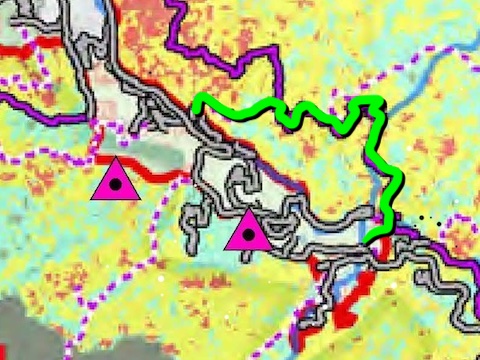
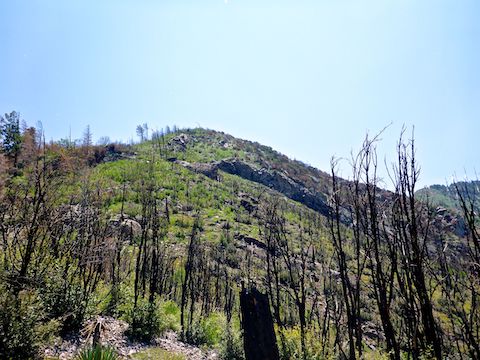
I last hiked Mount Lemmon in 2019, to the Upper Lemmon Canyon Pools. I would have hiked the Catalina Mountains last year, but on June 5 lightning ignited the Bighorn Fire. By the time the Bighorn Fire was 100% contained on July 23, it burned 119,978 acres.
Not everything within a burn area actually burns: Fire tends to hopscotch about, and those areas which actually burn will burn at different intensities. (See photo essay.) Just a few days ago, I saw some photos from Marshall Gulch Trail #3 and Wilderness of Rocks Trail #44, which showed the route to Upper Lemmon Canyon Pools was in pretty decent shape. 👍
So, instead of checking out Upper Lemmon Canyon for myself, I instead decided to hike Butterfly Trail #16 and, if I was making good time and not too sore, check out the observatories and antenna farms on Mount Bigelow.
It took my wife & I as much time to drive from I-10 across Tucson, and up Mount Lemmon, as it did for us to drive to Tucson. At least there was no construction on Grant Rd., and no looky-loos on the Catalina Highway. I started hiking from the Bigelow Trailhead at 9:30 a.m., with plans for my wife to meet me three hours later at the Butterfly Trailhead, to see if I would complete the loop, or call it a day.
Hiking northbound, Butterfly Trail #16 starts on the left of the small Bigelow Trailhead. The trail switchbacks up 350 rooty, rocky, feet in ⅔ of a mile, to the saddle between Mount Bigelow and Kellogg Mountain. The unnumbered Bigelow Summit Trail is to the left and Kellogg Mountain Trail #45 to the right. (Note: The latter is not mentioned on the trail sign at the intersection, but is there.) 🏞
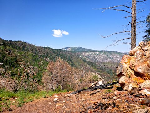
At 8,280 ft., the Mount Bigelow-Kellogg Mountain saddle is the high point of Butterfly Trail #16. The saddle is where the expansive views start: The Galiuro Mountains are easily visible 22 miles east, across the San Pedro River valley, and even beyond that, 50 miles to the Pinaleno Mountains. The town on the left side of the valley is San Manuel. The Catalina Mountains’ foothills were bright green.
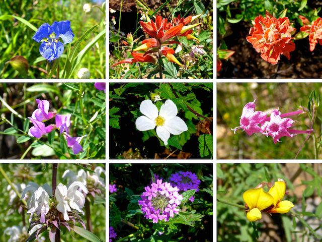
Top Row: western dayflower, Santa Catalina (not Rincon) indian paintbrush and — I think this is different — Sierra woolly indian paintbrush.
Middle Row: American vetch, wild / Virginia strawberry, (uncommonly pink) skyrocket.
Bottom Row: lemon beebalm, Dakota mock vervain, red and yellow pea.
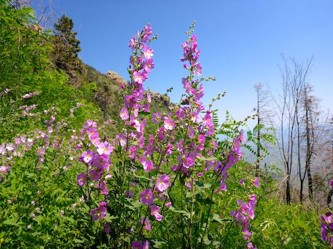
There were not many flowers on the climb to the Mount Bigelow-Kellogg Mountain saddle, but they began in earnest on the descent from it. As I was photographing a few, I thought I heard the sound of metal on rock, but did not see any other hikers. Beside the flowers pictured above & below, I spotted primrose, mullein, Arizona thistle, western yarrow, scarlet penstemon, Wright’s goldenrod, Richardson’s geranium, pineywoods geranium, raspberry, blooming wild / Virginia strawberry, and fleabane. 🤗
There was a fair amount of growth along the well-groomed trail. I turned a corner of the first switchback down, bumping into an older pair of Butterfly Trail #16 maintenance volunteers. (The source of the clinking sound.) They told me the growth got much worse ahead. They were not kidding!
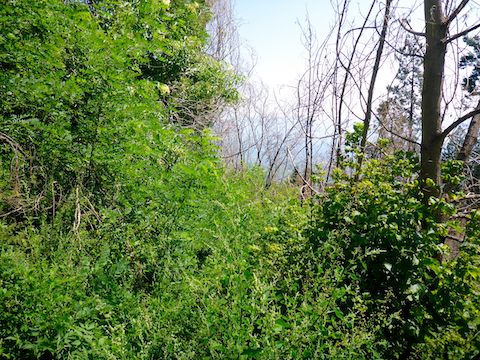
Butterfly Trail #16 overgrowth often obscures pitfalls caused by Bighorn Fire-damaged trees’ uprooted root bulbs. The overgrowth is waist high. There are prickler vines, but at least no cat claw. Mind your footing. When the trail is visible, it’s in good shape.
I found the best flowers — particularly dense patches of yellow columbine and pink thicket / Fendler’s globemallow — the second mile of Butterfly Trail #16, as it heads north along the east slope of Mount Bigelow. 📸
After descending 560 ft. in a mile from the Mount Bigelow-Kellogg Mountain saddle, Butterfly Trail #16 reaches a second saddle on the north slope of Mount Bigelow, separating it from Westfall Knob. Novio Spring, the falls, and the F-86 wreck site are in the canyon on the left.
From the north end of Westfall Knob, Butterfly Trail #16 descends 800 ft. in a mile. The signed junction with Davis Spring Trail #31 is two-thirds of the way down. The descent is actually the longest stretch of good trail I experienced.
… which was quickly followed by the worst section of Butterfly Trail #16. The vegetation was so dense, I wandered off trail, and could not spot where it was I had gone wrong. I battered about for a bit, then considered my options. Not wanting to repeat my experience at the bottom of Willow Springs Canyon last year, I decided to bail. ↩️
It was a long, slow, trudge back up Butterfly Trail #16. I took breathers every 100 ft. up, and even several 10 minute sit down breaks. On my break back at the Davis Spring Trail #31 junction, I went to call my wife about the change in plans, only to realize I had left my phone in the car. (If there is reception anywhere on this hike, it would be near Westfall Knob, with line-of-sight to Mount Lemmon.)
A little over a mile out from Bigelow Trailhead, about 2:00 p.m., I bumped into a mom and her son hiking northbound. She said some time previously, they had hiked southbound, and had to turn around due to overgrowth. Now, they were trying the opposite way. That did not seem wise. Personally, I was exhausted.
Covered in leaf stains, pollen and soot, I arrived at the Bigelow Trailhead just after 3:00 p.m. — only to see my Acura RDX drive off. Argh! Thankfully, there were some very kind folks there who offered to drive me up to Butterfly Trailhead to reconnect with my wife. (She’d been alternating trailheads every 15 minutes, looking for my late ass.) 👀
I cramped several times on the way back down the Catalina Highway. We ate dinner at La Hacienda in Oro Valley. All told, after my hike, I drank a V8, three waters, a Gatorade, and two beers before I peed after dinner for the first time in seven hours. Think I was dehydrated?
Directions: From I-10 in Tucson, take Exit 256. Head east on Grant Rd. for 8.5 miles. Turn left onto Tanque Verde Rd. In 3.3 miles, turn left onto the Catalina Highway. In 24.0 very twisty miles (speed limit 35 mph), the Bigelow Trailhead is on the right. The Butterfly Trailhead is 3.0 miles further, also on the right.
GPS File: Butterfly_Trail_16_Catalina_Mountains
Distance: 6.27 miles
AEG: 1,740 ft.
Time: Unknown, but slow. (Forgot to turn off GPS after hike.) 🙄
Hiking Video
Hiking Butterfly Trail #16, Catalina Mountains from Preston McMurry on Vimeo.