
 were all along the C&O Canal in the Paw Paw Quad, between Bonds Landing and Oldtown. Mostly on the landward side of the canal though, so usually hard to access for a photograph.")
Prior to today’s hike on the C&O Canal towpath, I had completed 15 of 20 segments. Bonds Landing to Paw Paw is the 16th segment. (I skipped the 10th segment from McMahon’s Mill to Williamsport due to repairs along Big Slackwater.) With visits to family in Hagerstown for German Fest in August, and for Halloween, I expect to finish my “thru-hike” this year.
Driving to Bond’s Landing, in the deepest depths of Green Ridge State Forest, can be confusing if you have not been there before. I got turned around my first time, last Halloween, hiking from Little Orleans to Bonds Landing. Bring a GPS and follow the driving directions below! 🛰
It was a hair below freezing Friday morning, but a delay leaving our hotel in Hagerstown meant that the temp was a tolerable 41℉ when I started hiking at 10:30 a.m. I quickly realized I had taken our car keys with me, which would have left me without a shuttle, and worse yet stranded my wife. Disaster averted, I began my C&O Canal hike in earnest.
MP 151.0: Bonds Landing is right on the Potomac River … Because how else would you launch a boat? It has two numbered campsites: The one nearer the C&O Canal has only a picnic table and fire pit. The site closer to the river, has a fire pit, two picnic tables, a small stage (!) with audience benches, and actual his & hers pit toilets. If you look up, you may spot a tree with a sign indicating the Potomac River’s 1985 high-water mark. 🌊
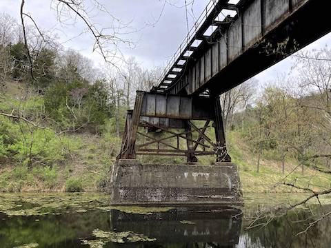
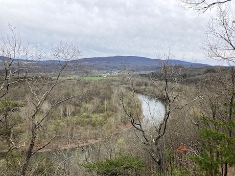
MP 151.2: Other than the Roby Hollow Railroad Bridge, there’s nothing of note the first three miles of this C&O Canal segment. So, the bridge makes a useful mileage marker if you miss one of the C&O Canal’s mileposts, which are foot high, brown painted 4x4s with white numbers, placed every mile.
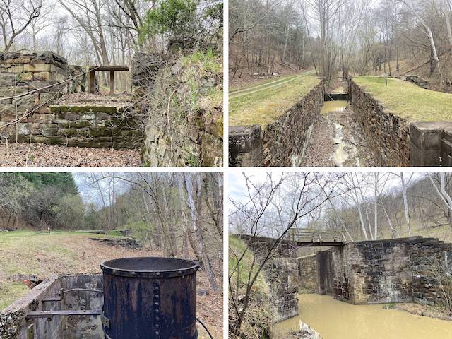
MP 153.1: The C&O Canal bed was more or less walkable at Lock 61. So, I figured I would film myself walking up the middle of Lock 61. But the far end was blocked by small pool, and I decided against getting wet, like I would on one of my Mogollon Rim hikes.
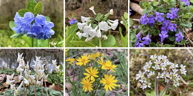
Top Row: Virginia bluebell, white Virginia bluebell, ground ivy.
Bottom Row: Dutchman’s breeches, ragwort (I believe Packera aurea), Early saxifrage.
About ¼ mile past Lock 61 was an orange sign: “Towpath Closed – 1.5 Miles Ahead – Follow Detour”. Right next to the sign was a green-labelled carsonite trail post indicating the footpath is part of the Great Eastern Trail. A few yards up the footpath is Green Ridge State Park Campsite 66 is, which is at the end of Outdoor Club Rd. which leads back to Mertens Ave., then Carroll Rd. I decided to soldier on.
MP 154.1: Lock 62 is adjacent to Sorrel Ridge Campground, which is right on the Potomac River. It has a portapotty, picnic table, grill, fire pit, direction & distance sign and trash bag dispenser. The well hand pump actually had a working handle, which gave water. I drank iodine-treated pump water at Horsepen Branch Campground (MP 26.1), but I don’t think the pumps are treated this far upriver. 🤔
Just past Lock 62, the C&O Canal towpath crosses Sandy Flat Hollow, then turns right, at a 90° angle away from Potomac River, up Tunnel Hollow. When the C&O Canal has water, it it usually dark. In Tunnel Hollow, it looked like coffee with lots of creamer.
MP 154.5: I was expecting “Lock 63”, but what I found was Lock 63⅓. Why the odd numbering? Because Lock 65 — the Missing Lock — was never built. (The Canal Company dropped it to reduce costs, adjusting the location of the locks in Tunnel Hollow to compensate. Lock 63⅓ was completed in 1850, but a cement datestone reads “1910”, when the C&O Canal was already on its last legs.
Lock 64⅔ is 100 yds. further up Tunnel Hollow. Originally planned to be an 8 ft. lift, to compensate for Missing Lock 65, it and it’s neighbors instead had 10 ft. lifts. The coffee-colored water was audibly flowing at Lock 64⅔. ☕️
The flow was louder at Lock 66, another 100 yds. up the C&O Canal. The most interesting thing about Lock 66 was a thick, rivetted, steel tube. Maybe 18″ diameter, the tube is braced with steel supports to a cement wall. Google is no help determining it’s function. For more info, see Locks on the Chesapeake and Ohio Canal.
I arrived at the detour at 12:50 p.m. The flag lady was very nice, and we had a good conversation while I waited for the dump trucks to descend the dirt road that is Tunnel Hill Trail. (She wasn’t the first talkative flag person I’ve met.) While the ceiling of Paw Paw Tunnel will soon need repairs, the current $10 million project is to clear landslides, and reinforce loose rock, on Paw Paw Tunnel’s north approach. And afterwards to restore the land to its prior, semi-natural state.
Once the dump trucks were back in Tunnel Hollow, I headed up steep Tunnel Hill Trail. I was trying to beat the loaded trucks to the top of the ridge, but they eventually passed me. When I caught up to the drivers at the top, one said “I tell you what, I’m pretty impressed: You stayed right there with me.” 💪
I jogged most of the ½ mile descent. About halfway down the trail splits: Left to Paw Paw Tunnel’s south entrance; right more directly to Paw Paw Campground. I started left, but turned around and went right, as I was out of time to double back into Paw Paw Tunnel.
Bond’s Landing Directions: From I-68, take exit 68 onto Orleans Rd. south. Mind the free range turkey 1.3 miles south of I-68. Little Orleans is 5.8 miles south of I-68. Continue across bridged Fifteen Mile Creek. Immediately bend right onto Oldtown Orleans Rd. Distances measured as total distance from Fifteen Mile Creek. In 2.8 miles, turn left off pavement onto dirt Carroll Rd. Point Lookout, 300 yds. ahead on the left, is worth a stop. Past Point Lookout, Caroll Rd. gradually decreases in width & quality. A car could drive it, but SUV recommended, especially for a couple of creek crossings. After 5.8 miles, just past Roby Cemetery, there’s a confusing 4-way intersection, that resembles an X more than a ➕: Don’t make a sharp left, and don’t continue straight-ish & up, instead bend left onto Kasecamp Rd. & down. Kasecamp Rd. turns left, paralleling the landward side of the C&O Canal. After 7.2 miles, turn right onto Bond’s Landing Rd. Park wherever.
Paw Paw Directions: From I-68, take US-522 south to Berkeley Springs, WV. Turn right on WV-9 / Cacapon Rd. The town of Paw Paw is in 24 twisty miles. Continue through town, across the Potomac River. A ½ mile past the river, turn right into Paw Paw Tunnel Campground. If you are doing a shuttle hike / key exchange, the driving route from Bonds Landing to Paw Paw is included in the GPS file attached below.
GPS File: CO_Canal_150to156_Bonds_Landing_to_Paw_Paw
Distance: 8.21 mi.
AEG: 593 ft.
Time: 2h 38m
Hiking Video
C&O Canal: Bond’s Landing to Paw Paw from Preston McMurry on Vimeo.