

I barely slept Monday night, after hiking the C&O Canal from Cohill Station to Little Orleans. Too sore. No idea why, as the C&O Canal is basically flat. I felt better after hiking the Canal 16 miles from Great Falls to Edward’s Ferry! Nonetheless, after only one day’s rest, and despite lingering stiffness, on Wednesday we headed out.
Getting to Little Orleans is straightforward. Driving to Bond’s Landing, in the deepest depths of Green Ridge State Forest, can be confusing if you have not been there before. I decided to drive to Bond’s Landing with my shuttle driving wife first, to show her the way, before she dropped me off back at Fifteen Mile Creek Campground. Good idea too, as I got misdirected, circling around between St. Martin Cemetery and St. Patrick Catholic Church. Bring a GPS and follow the directions below! 🛰
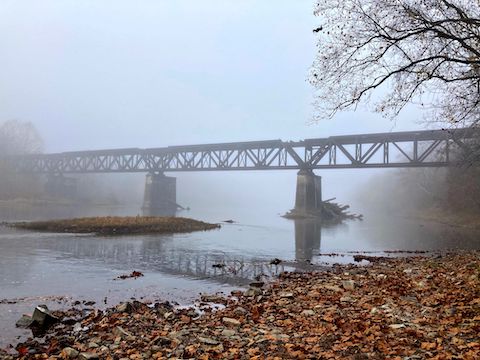
It was quite foggy, particularly over the Potomac River, when I finally started hiking the C&O Canal towpath at 8:40 a.m.
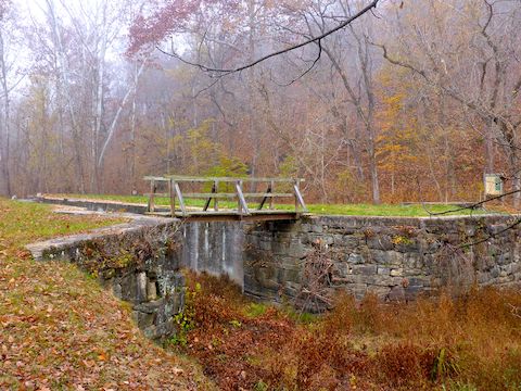
MP 141.0: Or, more accurately, 9:00 a.m., as I first spent 20 minutes checking out Fifteen Mile Creek Aqueduct. There’s an interesting info sign there, discussing labor relations with the canal workers. (I show the sign in my hiking video, below.) America’s early infrastructure was built on the backs of Irish immigrants.
Fifteen Mile Creek Aqueduct’s name is heftier than it’s structure. At 110 ft. long, with a single 50 ft. arch, Fifteen Mile Creek Aqueduct is the best preserved of the C&O Canal’s six single-arch aqueducts. The Irish laborers who built the aqueduct are buried at nearby St. Patrick’s Catholic Church. ☘️
Just past the Fifteen Mile Creek Aqueduct, there was a tracked Bobcat that looked like a combo crane, plow and compactor. For at least a mile, the piles of leaves I was shuffling through were disturbed by track marks. Also, there were trimmed bits of grab & stabs on the towpath. And that was it for the next 2½ miles. (There really isn’t much between Little Orleans and Bond’s Landing.)
MP 143.4: There’s a well-worn footpath up to the Potomac Appalachian Trail Club (PATC) cabin on Property Dr. — which you can follow a mile back to Bill’s Place in Little Orleans, for a short 3½ mile loop. Otherwise you are committed to either hiking the C&O Canal another 12½ miles to Paw Paw, or having someone drive deep into Green Ridge State Forest to shuttle you out.
Just past the footpath, is the first of two Western Maryland Railroad bridges on this segment of the C&O Canal. Though trains no longer run on this line, I still often heard them on the West Virginia side of the Potomac River. There was less graffiti on the pilings than I expected. 🚂
MP 144.5: Devil’s Alley Campground is right on the Potomac River, a ½ mile past Lock 58. It has a picnic table, grill, fire pit, direction & distance sign and doggie doo bag dispenser. The well hand pump actually had a working handle, but I had places to go and things to do, so I didn’t wait for the pump to give water. Not sure I’d trust it anyway, as the pump is only 20 ft. from the portapotty.

MP 146.5: Lock 59 had an interesting approach in that it looked like a rocky v-shaped creek bottom than a canal bed. There was no nearby cliff for rocks to tumble off of, so I wonder how it got to be that way? Enough remained of Lockhouse 59’s stone foundation to provide a decent wind break.
MP 147.1: C&O Canal mileposts are foot high, brown painted 4x4s with white numbers, placed every mile. Just before MP 147 is the actual Devil’s Alley — a creek / canyon — for which the campground 2½ miles ago is named. A hundred yards past the post, in an area quite tangled by vines, is the second railroad bridge of the Little Orleans to Bond’s Landing segment.
The next mile of the C&O Canal bed was filled with water. About milepost 147.7, directly opposite some scarey looking buildings, was a small “land bridge” you could bail across to Kasecamp Rd. — if you are willing to brave the chainsaws and/or banjos. Kasecamp Rd. loops around the base of Stickpile Hill, connecting at one end to Bond’s Landing, and at the other to Carroll Rd. (See driving directions, below.)

MP 149.3: Another two mile walk to the next item of note, Stickpile Hill Campground. I did not get a good look at it, as a couple of folks were setting up an early camp there, and I did not want to intrude. I assume it has the usual amenities. I just waved, said “howdy”, and kept on keeping on.
MP 149.6: Lock 60 had perhaps the single best fall color tree on the Little Orleans to Bond’s Landing segment. But there was a non-collapsed house on the landward side and, unsure where the park ended and private property began, I stayed on the towpath side of the C&O Canal.
MP 150.0: My shuttle driving wife was parked where Bond’s Landing Rd. crosses the C&O Canal, not down on the landing itself. She had some difficulty negotiating the narrow road through Roby Hollow, including having to back up our rental SUV when a minivan wussed out on a creek crossing. I downed a refreshing hiking beer, then we stopped at Point Lookout on the way back to Little Orleans, and on to our basecamp in Hagerstown.
Little Orleans Directions: From I-68, take exit 68 onto Orleans Rd. south. Mind the free range turkey 1.3 miles south of I-68. 5.8 miles south of I-68, make a sharp left onto High Germany Rd. Pass by Bill’s Place, through the 1-lane underpass. Turn right into Fifteen Mile Creek Campground. There is no fee for simply parking.
Bond’s Landing Directions: Follow the above directions to Little Orleans. Rather than making the sharp left, continue across bridged Fifteen Mile Creek. Immediately bend right onto Oldtown Orleans Rd. Distances measured as total distance from Fifteen Mile Creek. In 2.8 miles, turn left off pavement onto dirt Carroll Rd. Point Lookout, 300 yds. ahead on the left, is worth a stop. Past Point Lookout, Caroll Rd. gradually decreases in width & quality. A car could drive it, but SUV recommended, especially for a couple of creek crossings. After 5.8 miles, just past Roby Cemetery, there’s a confusing 4-way intersection, that resembles an X more than a ➕: Don’t make a sharp left, and don’t continue straight-ish & up, instead bend left onto Kasecamp Rd. & down. Kasecamp Rd. turns left, paralleling the landward side of the C&O Canal. After 7.2 miles, turn right onto Bond’s Landing Rd. Park wherever.
GPS File: CO_Canal_MP141to150_Little_Orleans_to_Bonds_Landing
Distance: 10.37 mi.
AEG: 197 ft.
Time: 3h 14m
Hiking Video
C&O Canal: Little Orleans to Bond’s Landing from Preston McMurry on Vimeo.