

Today was my second of two Halloween week hikes along the Chesapeake & Ohio Canal Towpath.
My first hike, on Sunday, was supposed to be from Carderock Recreation Area to Pennyfield Lock 22, or milepost (MP) 11 to 20, but I bailed at Great Falls Tavern (MP 14.4) due to heavy rain. I considered a number of options, including skipping the six miles I did not complete, but when I finish hiking the C&O Canal, I want to be able to honestly say, “I did the whole thing.” 😇
So, today I did the missing six miles from Great Falls Tavern to Pennyfield Lock 22, then did my planned Wednesday hike, the next eleven miles to Edward’s Ferry at Lock 25 (MP 31.0). Last time I hiked that far in a day was in 2015, hiking Aravaipa Canyon from end-to-end. (It’s a short canyon.) Thankfully, the C&O Canal towpath is just as flat as Aravaipa.
Note: The attached GPS files (below) covers both segments, Carderock to Pennyfield Lock 22, and Pennyfield Lock 22 to Edward’s Ferry at Lock 25. This blog, is about hiking from Great Falls to Edward’s Ferry.
The first thing I noticed, at the Great Falls snack bar, was a strange object, apparently with an end for listening, and another for speaking, and which appeared to be activated by round, metallic, objects known as “coins”. I have heard the elders tell tales of the “payphone” …
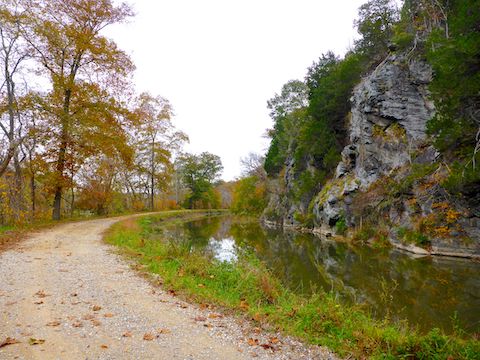
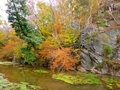
The C&O Canal towpath drains really well, and it was basically dry after several days of rain. Though overcast most of the Wednesday, it did not rain, until I got some sprinkles at Edward’s Ferry. Despite the clouds, the lack of rain meant there was decent enough light to take pictures of canal artifacts and low-hanging leaves. (Leaves high up in trees still appeared black in my viewfinder, requiring a bit more post-processing to draw out their natural color.) 🍂
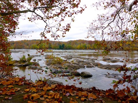
Getting pictures of the fall colors was especially important to me because the Potomac River appeared just past peak, whereas usually on Halloween I’m lucky there’s any color left at all.
There were a number of memorial benches between Great Falls and Edward’s Ferry. I wasn’t keeping track, but I’m guessing one every mile or so.
I did not see the number of dog walkers I usually see on the C&O Canal, despite the weather being better than on Sunday. (I saw numerous runners on Sunday; one disgustingly motivated individual passed me three times.) I did see some bicyclists with panniers — i.e. “saddlebags” — who must have been bike camping. I also saw some bird watchers by Swain’s Lock 21, and some folks fishing by the Seneca Creek Aqueduct. But, for the most part, I had the towpath to myself.
Maybe because I was hiking 18 miles? 🤔
Many — most? — C&O Canal locks have some sort of vehicle access, or nearby parking. The parking is usually on the side of the Canal opposite the Potomac River, with a foot bridge to the towpath. (Edward’s Ferry is one of the exceptions.) Most of the parking lot trailheads also have some sort of sanitary facility: Outhouses at the smaller or more remote trailheads, pit toilets (Edward’s Ferry) or even flush toilets & running water at the larger ones (Great Falls Tavern).
If you don’t have anyone willing to shuttle for your 11- or 18-mile hike, you can do an out & back hike from any lock / trailhead to any other lock / trailhead in roundtrip distances ranging from 1.4 miles on up. The C&O Canal trailheads and their facilities:
MP 14.4: Great Falls Tavern / Lock 20: Huge gated pay parking lot, visitor’s center, flush toilets, snack bar, water fountain.
MP 16.6: Swain’s Lock 21 has a tiny parking lot, four outhouses, free campground and a water fountain.
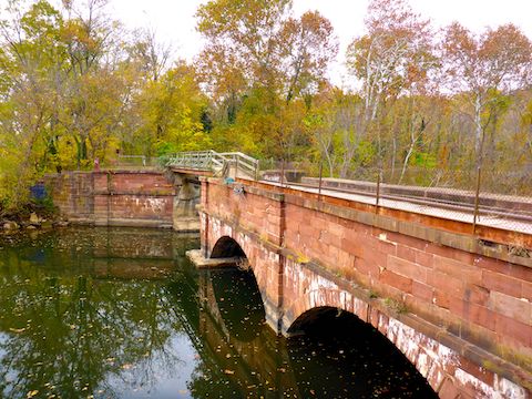
MP 19.7: Pennyfield Lock 22 has a small parking lot a ¼ mile walk away, where there are several outhouses. Lockhouse 22 is available for rent as part of the Canal Quarters program. 🛌
MP 22.1: Violette’s Lock 23 has a medium-sized parking lot, with a canoe / kayak ramp, a picnic area and some sort of sanitary facility, probably outhouses.
MP 22.8: Riley’s Lock 24 has parking large enough to have lines on it, five outhouses, a water fountain, a canoe / kayak ramp, and picnic areas either side of the Seneca Creek Aqueduct.
MP 26.0: Horsepen Branch Campground has no parking, as the nearest trailhead is at Sycamore Landing, just over a mile away. (A good distance for a young family camping trip.) Camping is free. There is one outhouse and a well hand pump.
MP 27.3: Sycamore Landing has a medium-sized parking lot with wood stairs down to the Potomac River. The National Park Service claims it is a “boat ramp”, but you are not launching anything bigger than a canoe or kayak. For larger watercraft, go to Edward’s Ferry. 🛶
MP 30.5: Chisel Branch Campground has no parking as the nearest trailhead is at Edward’s Ferry, a ½ mile away. Camping is free. There is a one outhouse and a well hand pump.
MP 31.0: Edward’s Ferry has a medium-sized parking lot, outhouse, pit toilet (for the refined hiker) and picnic area. Lockhouse 25 is available for rent as part of the Canal Quarters program. It also has a proper boat ramp, where you could back a trailer into the Potomac River.

Picnic areas typically have a picnic table, grill, fire pit, well hand pump and doggie doo bag dispenser. Unlike hiking in Phoenix, bags full of canine crap were not scattered along the C&O Canal. Camping is only legal at designated camp sites, but it’s easy to mistake a picnic area for a campground as they have all the same amenities. 😇
I picked up a fresh water bottle from my wife at Pennyfield Lock 22. (I rarely bring any hiking gear on my flyaway hikes.) I refilled my water bottles from the water fountain at Riley’s Lock 24 and the well hand pump at Horsepen Branch Campground. The well water looked clear in my hand, and tasted okay, but was tan / yellowish in my bottle. But all pumps are treated with iodine, so it didn’t give me the squirts.
The best fall colors today, on the C&O Canal, were between Great Falls Tavern and Violette’s Lock 23: A smorgasbord of yellows, oranges and reds. Past that to Edward’s Ferry, with the notable exception above, yellow predominated. 📸
The first nine miles today, I averaged 3.4 mph. That dropped to 3.3 mph in the third quarter of my C&O Canal. After taking my only sit down break of the day, at Horsepen Branch Campground, I got my average back up to 3.4 mph. I was truckin’.
Great Falls Directions: From I-495, take exit 41, west onto Clara Barton Parkway. In 1.5 miles, slant left onto Macarthur Boulevard. (Yes, the “a” in “arthur” is lowercase.) In 2.2 miles, stay left on Macarthur Blvd. In another 1.2 miles is a gated entrance. Current fees are $15 per vehicle, or $7 for bicycles & pedestrians. Parking is on the right of the traffic circle. A generally less traffic strewn option, from Hagerstown or Frederick, is to take MD-85, MD-28 and MD-190 to Great Falls.
Edward’s Ferry Directions: From I-270, take exit 109 onto MD-109 / Old Hundred Rd. In 5.3 miles, in Barnsville, take a quick right-left to stay on MD-109. In another 6.0 miles on MD-109, in Poolesville, make a quick right-left onto Willard Rd. In 0.6 miles, slant right onto Westerly Rd. In 1.5 miles, turn left onto Edward’s Ferry Rd. To avoid I-270, which carries a lot of D.C. traffic, take MD-85 and MD-28 to Beallsville, before turning south on MD-109.
GPS File: CO_Canal_MP11to20_Carderock_to_Pennyfield
GPS File: CO_Canal_MP20to31_Pennyfield_to_Edwards_Ferry
Distance: 18.35 mi.
AEG: 319 ft.
Time: 5h 36m
Hiking Video
Hiking C&O Canal: Great Falls to Edwards Ferry from Preston McMurry on Vimeo.